
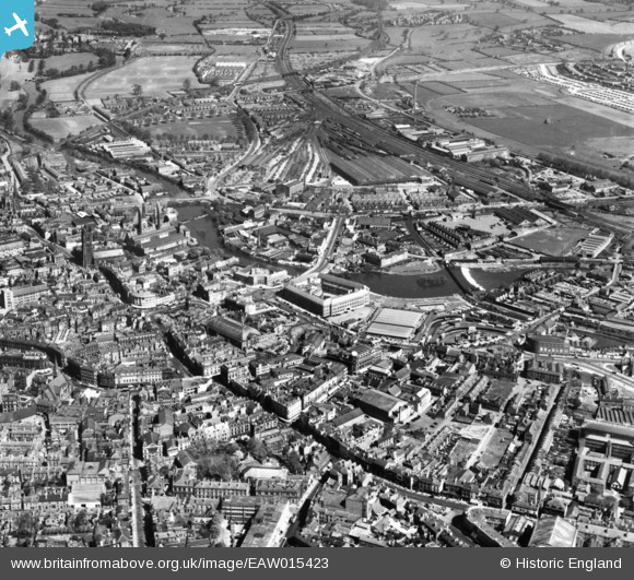
EAW015423 ENGLAND (1948). The city centre and St Mary's Goods Depot, Derby, 1948. This image has been produced from a print.
© Copyright OpenStreetMap contributors and licensed by the OpenStreetMap Foundation. 2026. Cartography is licensed as CC BY-SA.
Nearby Images (16)
EAW015423

EPW041813

EAW004658

EPW041812

EPW055028

EPW005813

EPW005817

EPW055021

EAW002466

EAW004660

EPW021119

EPW021123

EPW021120

EPW021121

EPW005815

EPW021122

Details
| Title | [EAW015423] The city centre and St Mary's Goods Depot, Derby, 1948. This image has been produced from a print. |
| Reference | EAW015423 |
| Date | 7-May-1948 |
| Link | |
| Place name | DERBY |
| Parish | |
| District | |
| Country | ENGLAND |
| Easting / Northing | 435461, 336371 |
| Longitude / Latitude | -1.4724836940688, 52.923262770298 |
| National Grid Reference | SK355364 |
Pins

60's Soul |
Thursday 29th of January 2026 10:11:15 PM | |
|
60's Soul |
Thursday 29th of January 2026 10:10:39 PM | |
|
60's Soul |
Thursday 29th of January 2026 10:09:04 PM | |
|
60's Soul |
Thursday 29th of January 2026 10:08:35 PM | |
|
60's Soul |
Thursday 29th of January 2026 10:07:53 PM | |
|
60's Soul |
Thursday 29th of January 2026 10:06:58 PM | |
|
60's Soul |
Thursday 29th of January 2026 10:06:07 PM | |
|
60's Soul |
Thursday 29th of January 2026 10:05:32 PM | |
|
60's Soul |
Thursday 29th of January 2026 10:05:09 PM | |
|
60's Soul |
Thursday 29th of January 2026 10:04:40 PM | |
|
60's Soul |
Thursday 29th of January 2026 10:04:14 PM | |
|
60's Soul |
Thursday 29th of January 2026 10:03:47 PM | |
|
60's Soul |
Thursday 29th of January 2026 09:58:44 PM | |
|
60's Soul |
Thursday 29th of January 2026 09:57:26 PM | |
|
gerry-r |
Saturday 10th of August 2024 06:34:32 PM | |
|
aremla |
Sunday 16th of January 2022 03:28:04 PM | |
|
redmist |
Saturday 22nd of June 2019 11:25:02 PM | |
|
Steve H |
Tuesday 3rd of October 2017 05:38:13 PM | |
|
gBr |
Monday 24th of October 2016 09:41:20 PM | |
According to Rail Map online (usually very reliable) http://www.railmaponline.com/UKIEMap.php and Wikipedia, this was Derby Nottingham Road |
Brightonboy |
Monday 24th of October 2016 10:24:24 PM |
|
gBr |
Monday 24th of October 2016 09:39:06 PM | |
|
Maitland |
Sunday 15th of May 2016 12:49:31 PM | |
|
Maitland |
Sunday 15th of May 2016 12:27:35 PM |