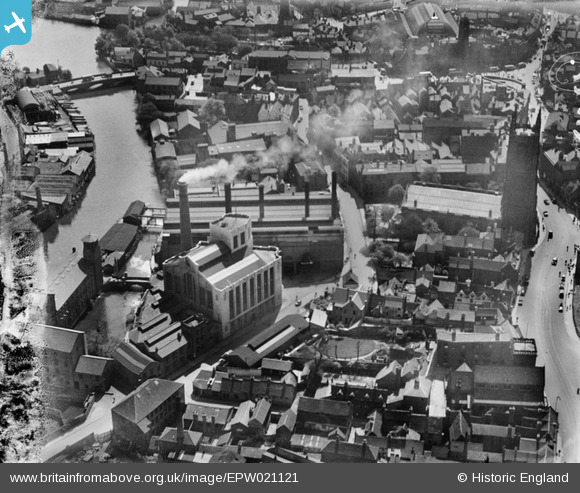
EPW021121 ENGLAND (1928). Corporation Power Station and All Saints' Church, Derby, 1928
© Copyright OpenStreetMap contributors and licensed by the OpenStreetMap Foundation. 2026. Cartography is licensed as CC BY-SA.
Nearby Images (17)
Details
| Title | [EPW021121] Corporation Power Station and All Saints' Church, Derby, 1928 |
| Reference | EPW021121 |
| Date | April-1928 |
| Link | |
| Place name | DERBY |
| Parish | |
| District | |
| Country | ENGLAND |
| Easting / Northing | 435287, 336553 |
| Longitude / Latitude | -1.4750522011921, 52.924910404487 |
| National Grid Reference | SK353366 |
Pins

MB |
Monday 24th of October 2016 12:12:09 PM | |

MB |
Monday 24th of October 2016 12:11:01 PM | |

MB |
Monday 24th of October 2016 12:09:47 PM | |

robclark800 |
Monday 25th of August 2014 07:43:01 PM | |

Gordy |
Saturday 26th of January 2013 03:27:24 AM | |

gellert |
Thursday 28th of June 2012 08:03:32 PM | |

gellert |
Thursday 28th of June 2012 08:00:07 PM | |

gellert |
Thursday 28th of June 2012 07:58:57 PM | |

gellert |
Thursday 28th of June 2012 07:57:10 PM | |

gellert |
Thursday 28th of June 2012 07:55:22 PM | |
All Saints, given cathedral status on 1 July 1927. |

gBr |
Thursday 19th of November 2015 07:15:14 PM |


![[EPW021121] Corporation Power Station and All Saints' Church, Derby, 1928](http://britainfromabove.org.uk/sites/all/libraries/aerofilms-images/public/100x100/EPW/021/EPW021121.jpg)
![[EPW021120] Corporation Power Station, Derby, 1928](http://britainfromabove.org.uk/sites/all/libraries/aerofilms-images/public/100x100/EPW/021/EPW021120.jpg)
![[EPW021123] Corporation Power Station and All Saints' Church, Derby, 1928](http://britainfromabove.org.uk/sites/all/libraries/aerofilms-images/public/100x100/EPW/021/EPW021123.jpg)
![[EPW021122] Corporation Power Station and All Saints' Church, Derby, 1928](http://britainfromabove.org.uk/sites/all/libraries/aerofilms-images/public/100x100/EPW/021/EPW021122.jpg)
![[EPW021119] Corporation Baths and All Saints' Church, Derby, 1928](http://britainfromabove.org.uk/sites/all/libraries/aerofilms-images/public/100x100/EPW/021/EPW021119.jpg)
![[EAW002468] The site of the Phoenix Iron Foundry, Derby Silk Mill and environs, Derby, 1946](http://britainfromabove.org.uk/sites/all/libraries/aerofilms-images/public/100x100/EAW/002/EAW002468.jpg)
![[EAW004660] The city centre, Derby, from the west, 1947](http://britainfromabove.org.uk/sites/all/libraries/aerofilms-images/public/100x100/EAW/004/EAW004660.jpg)
![[EAW004661] The city centre, Derby, from the west, 1947](http://britainfromabove.org.uk/sites/all/libraries/aerofilms-images/public/100x100/EAW/004/EAW004661.jpg)
![[EAW004663] The city centre, Derby, from the west, 1947](http://britainfromabove.org.uk/sites/all/libraries/aerofilms-images/public/100x100/EAW/004/EAW004663.jpg)
![[EAW002466] The site of the Phoenix Iron Foundry, Derby Silk Mill and environs, Derby, 1946](http://britainfromabove.org.uk/sites/all/libraries/aerofilms-images/public/100x100/EAW/002/EAW002466.jpg)
![[EAW002467] St Mary's Bridge and nearby industrial buildings, Derby, 1946](http://britainfromabove.org.uk/sites/all/libraries/aerofilms-images/public/100x100/EAW/002/EAW002467.jpg)
![[EPW055025] St Mary's Goods Yard, works off Stuart Street and the Central Power Station, Derby, 1937](http://britainfromabove.org.uk/sites/all/libraries/aerofilms-images/public/100x100/EPW/055/EPW055025.jpg)
![[EAW002465] St Mary's Bridge and nearby industrial buildings, Derby, 1946](http://britainfromabove.org.uk/sites/all/libraries/aerofilms-images/public/100x100/EAW/002/EAW002465.jpg)
![[EAW044088] The Bridge Gate ad King Street area, Derby, from the east, 1952](http://britainfromabove.org.uk/sites/all/libraries/aerofilms-images/public/100x100/EAW/044/EAW044088.jpg)
![[EPW055026] Queen Street, Derby, 1937](http://britainfromabove.org.uk/sites/all/libraries/aerofilms-images/public/100x100/EPW/055/EPW055026.jpg)
![[EAW015423] The city centre and St Mary's Goods Depot, Derby, 1948. This image has been produced from a print.](http://britainfromabove.org.uk/sites/all/libraries/aerofilms-images/public/100x100/EAW/015/EAW015423.jpg)
![[EPW041813] Riverside Gardens area and environs, Derby, 1933](http://britainfromabove.org.uk/sites/all/libraries/aerofilms-images/public/100x100/EPW/041/EPW041813.jpg)