
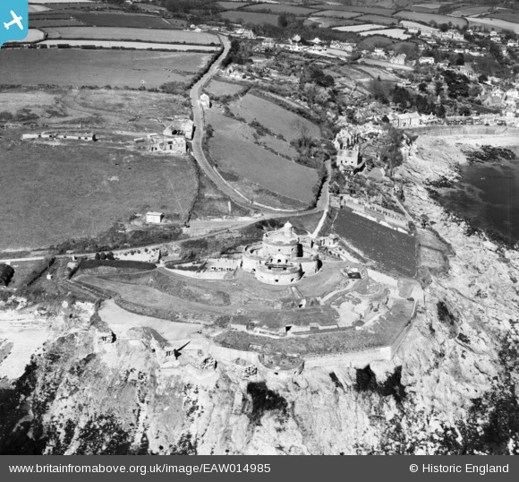
EAW014985 ENGLAND (1948). St Mawes Castle, St Mawes, 1948
© Copyright OpenStreetMap contributors and licensed by the OpenStreetMap Foundation. 2026. Cartography is licensed as CC BY-SA.
Nearby Images (7)
EAW014985

EAW005981

EAW014984

EAW005980

EAW005984

EAW005982

EAW005983

Details
| Title | [EAW014985] St Mawes Castle, St Mawes, 1948 |
| Reference | EAW014985 |
| Date | 27-April-1948 |
| Link | |
| Place name | ST MAWES |
| Parish | ST. JUST-IN-ROSELAND |
| District | |
| Country | ENGLAND |
| Easting / Northing | 184126, 32783 |
| Longitude / Latitude | -5.0224507315711, 50.155105369126 |
| National Grid Reference | SW841328 |
Pins

redmist |
Monday 29th of August 2022 06:23:16 PM | |
|
redmist |
Wednesday 25th of November 2020 01:51:50 PM | |
|
CornwallPhil |
Monday 1st of September 2014 09:16:04 PM | |
|
CornwallPhil |
Monday 1st of September 2014 09:15:27 PM | |
|
CornwallPhil |
Monday 1st of September 2014 09:14:09 PM | |
|
CornwallPhil |
Monday 1st of September 2014 09:13:06 PM |
User Comment Contributions

WW2 features at St Mawes Castle |
CornwallPhil |
Monday 1st of September 2014 09:21:35 PM |

St. Mawes Castle from the St. Mawes to Falmouth ferry August 1965. A young Class31 and brother enjoy the view. |

Class31 |
Monday 19th of May 2014 08:58:41 AM |
Coastal artillery fortress dating from the mid sixteenth century, designed to deter the French following the establishment of the Church of England by Henry VIII |
MB |
Sunday 26th of January 2014 10:50:16 AM |