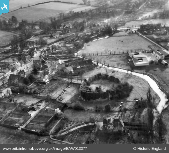
EAW013377 ENGLAND (1948). Eynsford Castle and environs, Eynsford, 1948. This image has been produced from a print.
© Copyright OpenStreetMap contributors and licensed by the OpenStreetMap Foundation. 2026. Cartography is licensed as CC BY-SA.
Nearby Images (21)
Details
| Title | [EAW013377] Eynsford Castle and environs, Eynsford, 1948. This image has been produced from a print. |
| Reference | EAW013377 |
| Date | 16-February-1948 |
| Link | |
| Place name | EYNSFORD |
| Parish | EYNSFORD |
| District | |
| Country | ENGLAND |
| Easting / Northing | 554160, 165753 |
| Longitude / Latitude | 0.21492714948358, 51.369384484261 |
| National Grid Reference | TQ542658 |
Pins
Be the first to add a comment to this image!


![[EAW013377] Eynsford Castle and environs, Eynsford, 1948. This image has been produced from a print.](http://britainfromabove.org.uk/sites/all/libraries/aerofilms-images/public/100x100/EAW/013/EAW013377.jpg)
![[EAW013378] Eynsford Castle and environs, Eynsford, 1948. This image has been produced from a print.](http://britainfromabove.org.uk/sites/all/libraries/aerofilms-images/public/100x100/EAW/013/EAW013378.jpg)
![[EAW034954] Eynsford Castle, Eynsford, 1951](http://britainfromabove.org.uk/sites/all/libraries/aerofilms-images/public/100x100/EAW/034/EAW034954.jpg)
![[EAW034951] Eynsford Castle, Eynsford, 1951](http://britainfromabove.org.uk/sites/all/libraries/aerofilms-images/public/100x100/EAW/034/EAW034951.jpg)
![[EAW034955] Eynsford Castle and the village, Eynsford, 1951](http://britainfromabove.org.uk/sites/all/libraries/aerofilms-images/public/100x100/EAW/034/EAW034955.jpg)
![[EAW013376] Eynsford Castle, Eynsford, 1948. This image has been produced from a print.](http://britainfromabove.org.uk/sites/all/libraries/aerofilms-images/public/100x100/EAW/013/EAW013376.jpg)
![[EAW034952] Eynsford Castle, Eynsford, 1951](http://britainfromabove.org.uk/sites/all/libraries/aerofilms-images/public/100x100/EAW/034/EAW034952.jpg)
![[EAW013380] Eynsford Castle and environs, Eynsford, 1948. This image has been produced from a print.](http://britainfromabove.org.uk/sites/all/libraries/aerofilms-images/public/100x100/EAW/013/EAW013380.jpg)
![[EAW034950] Eynsford Castle, Eynsford, 1951](http://britainfromabove.org.uk/sites/all/libraries/aerofilms-images/public/100x100/EAW/034/EAW034950.jpg)
![[EAW013379] Eynsford Castle and environs, Eynsford, 1948. This image has been produced from a print.](http://britainfromabove.org.uk/sites/all/libraries/aerofilms-images/public/100x100/EAW/013/EAW013379.jpg)
![[EAW029112] Furlongs Farm, Eynsford, 1950. This image was marked by Aerofilms Ltd for photo editing.](http://britainfromabove.org.uk/sites/all/libraries/aerofilms-images/public/100x100/EAW/029/EAW029112.jpg)
![[EAW029111] Furlongs Farm, Eynsford, 1950. This image was marked by Aerofilms Ltd for photo editing.](http://britainfromabove.org.uk/sites/all/libraries/aerofilms-images/public/100x100/EAW/029/EAW029111.jpg)
![[EAW029116] Furlongs Farm and environs, Eynsford, 1950. This image was marked by Aerofilms Ltd for photo editing.](http://britainfromabove.org.uk/sites/all/libraries/aerofilms-images/public/100x100/EAW/029/EAW029116.jpg)
![[EAW029109] Furlongs Farm, Eynsford, 1950. This image was marked by Aerofilms Ltd for photo editing.](http://britainfromabove.org.uk/sites/all/libraries/aerofilms-images/public/100x100/EAW/029/EAW029109.jpg)
![[EAW029110] Furlongs Farm, Eynsford, 1950. This image was marked by Aerofilms Ltd for photo editing.](http://britainfromabove.org.uk/sites/all/libraries/aerofilms-images/public/100x100/EAW/029/EAW029110.jpg)
![[EAW023110] The village, Eynsford, 1949](http://britainfromabove.org.uk/sites/all/libraries/aerofilms-images/public/100x100/EAW/023/EAW023110.jpg)
![[EAW029115] Furlongs Farm and environs, Eynsford, 1950. This image was marked by Aerofilms Ltd for photo editing.](http://britainfromabove.org.uk/sites/all/libraries/aerofilms-images/public/100x100/EAW/029/EAW029115.jpg)
![[EAW029117] Furlongs Farm, Eynsford, 1950. This image was marked by Aerofilms Ltd for photo editing.](http://britainfromabove.org.uk/sites/all/libraries/aerofilms-images/public/100x100/EAW/029/EAW029117.jpg)
![[EAW029114] Furlongs Farm, Eynsford, 1950. This image was marked by Aerofilms Ltd for photo editing.](http://britainfromabove.org.uk/sites/all/libraries/aerofilms-images/public/100x100/EAW/029/EAW029114.jpg)
![[EAW034956] The village, Eynsford, 1951](http://britainfromabove.org.uk/sites/all/libraries/aerofilms-images/public/100x100/EAW/034/EAW034956.jpg)
![[EAW034953] The village, Eynsford, 1951](http://britainfromabove.org.uk/sites/all/libraries/aerofilms-images/public/100x100/EAW/034/EAW034953.jpg)