
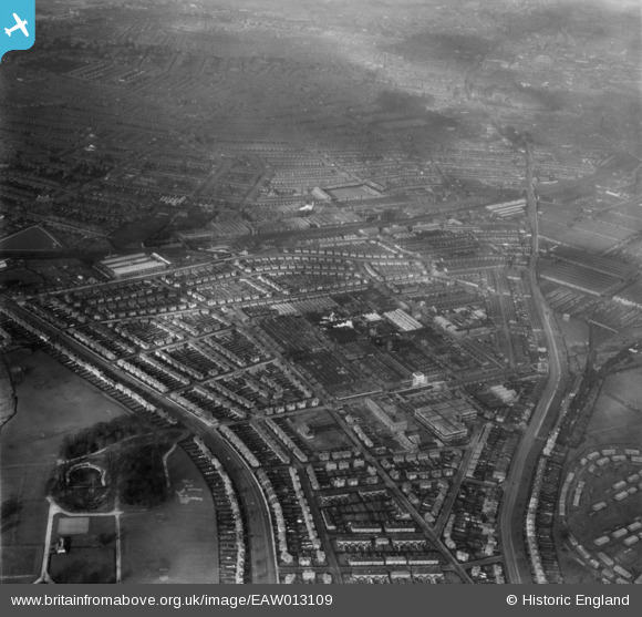
EAW013109 ENGLAND (1948). Osmaston Road, the Rolls Royce Nightingale Road Works and surrounding residential district, Osmaston, from the south-east, 1948
© Copyright OpenStreetMap contributors and licensed by the OpenStreetMap Foundation. 2026. Cartography is licensed as CC BY-SA.
Nearby Images (15)
EAW013109

EPW046673

EPW046672

EPW046679

EPW046674

EAW013112

EAW013107

EAW013117

EPW046678

EPW046675

EAW013111

EAW013119

EPW046677

EAW013108

EPW046676

Details
| Title | [EAW013109] Osmaston Road, the Rolls Royce Nightingale Road Works and surrounding residential district, Osmaston, from the south-east, 1948 |
| Reference | EAW013109 |
| Date | 4-February-1948 |
| Link | |
| Place name | OSMASTON |
| Parish | |
| District | |
| Country | ENGLAND |
| Easting / Northing | 436363, 333369 |
| Longitude / Latitude | -1.4594023271941, 52.896214605901 |
| National Grid Reference | SK364334 |
Pins

kath |
Thursday 17th of September 2020 04:16:07 PM | |
|
kath |
Thursday 17th of September 2020 04:15:11 PM | |
|
kath |
Thursday 17th of September 2020 04:14:20 PM | |
|
KhalSir |
Sunday 8th of November 2015 03:29:07 PM | |
|
Triggy |
Sunday 9th of February 2014 08:41:22 PM | |
|
Triggy |
Sunday 9th of February 2014 08:40:42 PM | |
|
Al |
Friday 6th of December 2013 07:32:28 PM | |
|
Al |
Friday 6th of December 2013 07:31:41 PM | |

Peter Kazmierczak |
Tuesday 26th of November 2013 10:29:45 PM | |
|
Peter Kazmierczak |
Tuesday 26th of November 2013 10:28:58 PM |
User Comment Contributions
Bofors AA Towers around the Rolls Royce works, Derby. |
cptpies |
Thursday 19th of December 2013 03:18:21 PM |