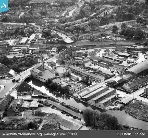
EAW011939 ENGLAND (1947). The S. C. Johnson and Son Works and the surrounding area, Yiewsley, 1947
© Copyright OpenStreetMap contributors and licensed by the OpenStreetMap Foundation. 2026. Cartography is licensed as CC BY-SA.
Nearby Images (9)
Details
| Title | [EAW011939] The S. C. Johnson and Son Works and the surrounding area, Yiewsley, 1947 |
| Reference | EAW011939 |
| Date | 17-October-1947 |
| Link | |
| Place name | YIEWSLEY |
| Parish | |
| District | |
| Country | ENGLAND |
| Easting / Northing | 505993, 180181 |
| Longitude / Latitude | -0.47247812323744, 51.510120758664 |
| National Grid Reference | TQ060802 |
Pins

Matt Aldred edob.mattaldred.com |
Sunday 1st of August 2021 06:04:47 PM | |

Class31 |
Friday 24th of January 2014 03:52:34 PM | |

Class31 |
Friday 24th of January 2014 03:51:05 PM | |

brian |
Tuesday 7th of January 2014 11:45:20 AM | |

brian |
Tuesday 7th of January 2014 11:42:26 AM | |

brian |
Monday 30th of December 2013 05:51:53 PM | |

brian |
Monday 30th of December 2013 05:43:35 PM | |

brian |
Monday 30th of December 2013 05:43:00 PM | |
Later to become the venue for a disreputable nightclub, 'Naughties'. |

The Laird |
Thursday 12th of May 2016 08:04:53 PM |

brian |
Monday 30th of December 2013 05:41:25 PM | |

brian |
Monday 30th of December 2013 05:39:03 PM | |

brian |
Monday 30th of December 2013 05:37:26 PM | |

brian |
Monday 30th of December 2013 05:36:10 PM | |

brian |
Monday 30th of December 2013 05:34:31 PM | |

brian |
Monday 30th of December 2013 05:29:05 PM | |

brian |
Monday 30th of December 2013 05:27:56 PM | |

brian |
Monday 30th of December 2013 05:26:25 PM | |

brian |
Monday 30th of December 2013 05:24:23 PM | |

brian |
Monday 30th of December 2013 05:21:47 PM | |

brian |
Monday 30th of December 2013 05:20:17 PM | |

brian |
Monday 30th of December 2013 05:18:44 PM | |

brian |
Monday 30th of December 2013 05:16:46 PM | |

brian |
Monday 30th of December 2013 05:15:31 PM | |

brian |
Monday 30th of December 2013 05:14:10 PM | |

brian |
Monday 30th of December 2013 05:09:13 PM | |

brian |
Monday 30th of December 2013 05:02:05 PM | |

brian |
Monday 30th of December 2013 04:53:54 PM | |

brian |
Monday 30th of December 2013 04:52:27 PM | |

brian |
Monday 30th of December 2013 04:50:41 PM | |

brian |
Monday 30th of December 2013 04:47:39 PM | |

brian |
Monday 30th of December 2013 04:46:00 PM | |

brian |
Monday 30th of December 2013 04:44:26 PM | |

brian |
Monday 30th of December 2013 04:43:23 PM |


![[EAW011939] The S. C. Johnson and Son Works and the surrounding area, Yiewsley, 1947](http://britainfromabove.org.uk/sites/all/libraries/aerofilms-images/public/100x100/EAW/011/EAW011939.jpg)
![[EAW011938] The S. C. Johnson and Son Works alongside the Grand Union Canal, Yiewsley, 1947. This image was marked by Aerofilms Ltd for photo editing.](http://britainfromabove.org.uk/sites/all/libraries/aerofilms-images/public/100x100/EAW/011/EAW011938.jpg)
![[EAW011935] The S. C. Johnson and Son Works, Yiewsley, 1947. This image was marked by Aerofilms Ltd for photo editing.](http://britainfromabove.org.uk/sites/all/libraries/aerofilms-images/public/100x100/EAW/011/EAW011935.jpg)
![[EAW011941] The S. C. Johnson and Son Works and the surrounding area, Yiewsley, 1947. This image was marked by Aerofilms Ltd for photo editing.](http://britainfromabove.org.uk/sites/all/libraries/aerofilms-images/public/100x100/EAW/011/EAW011941.jpg)
![[EAW011937] The S. C. Johnson and Son Works and the surrounding residential area, Yiewsley, 1947. This image was marked by Aerofilms Ltd for photo editing.](http://britainfromabove.org.uk/sites/all/libraries/aerofilms-images/public/100x100/EAW/011/EAW011937.jpg)
![[EPW052762] The area between Tavistock Road and Oldham Road, Yiewsley, 1937](http://britainfromabove.org.uk/sites/all/libraries/aerofilms-images/public/100x100/EPW/052/EPW052762.jpg)
![[EAW011942] The S. C. Johnson and Son Works and the surrounding area, Yiewsley, 1947. This image was marked by Aerofilms Ltd for photo editing.](http://britainfromabove.org.uk/sites/all/libraries/aerofilms-images/public/100x100/EAW/011/EAW011942.jpg)
![[EAW011936] The S. C. Johnson and Son Works and the surrounding area, Yiewsley, 1947. This image was marked by Aerofilms Ltd for photo editing.](http://britainfromabove.org.uk/sites/all/libraries/aerofilms-images/public/100x100/EAW/011/EAW011936.jpg)
![[EAW011940] The S. C. Johnson and Son Works and the surrounding area, Yiewsley, 1947. This image was marked by Aerofilms Ltd for photo editing.](http://britainfromabove.org.uk/sites/all/libraries/aerofilms-images/public/100x100/EAW/011/EAW011940.jpg)