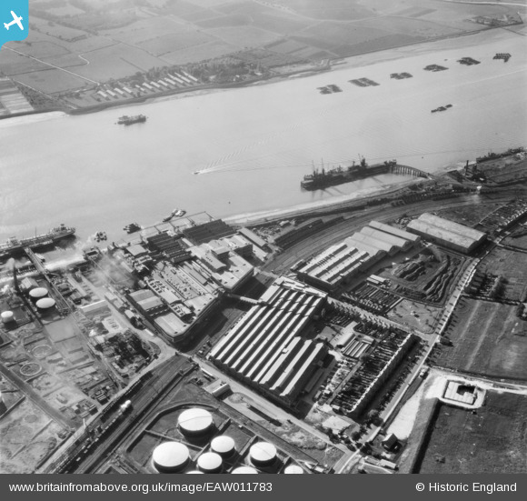
EAW011783 ENGLAND (1947). Thames Board Mills, Purfleet, 1947
© Copyright OpenStreetMap contributors and licensed by the OpenStreetMap Foundation. 2026. Cartography is licensed as CC BY-SA.
Nearby Images (30)
Details
| Title | [EAW011783] Thames Board Mills, Purfleet, 1947 |
| Reference | EAW011783 |
| Date | 9-October-1947 |
| Link | |
| Place name | PURFLEET |
| Parish | |
| District | |
| Country | ENGLAND |
| Easting / Northing | 555810, 177691 |
| Longitude / Latitude | 0.24386421116658, 51.476205875664 |
| National Grid Reference | TQ558777 |
Pins
Be the first to add a comment to this image!


![[EAW011783] Thames Board Mills, Purfleet, 1947](http://britainfromabove.org.uk/sites/all/libraries/aerofilms-images/public/100x100/EAW/011/EAW011783.jpg)
![[EAW010061] Thames Board Mills, Purfleet, 1947. This image was marked by Aerofilms Ltd for photo editing.](http://britainfromabove.org.uk/sites/all/libraries/aerofilms-images/public/100x100/EAW/010/EAW010061.jpg)
![[EAW010060] Thames Board Mills, Purfleet, 1947. This image was marked by Aerofilms Ltd for photo editing.](http://britainfromabove.org.uk/sites/all/libraries/aerofilms-images/public/100x100/EAW/010/EAW010060.jpg)
![[EAW011779] Thames Board Mills, Purfleet, 1947](http://britainfromabove.org.uk/sites/all/libraries/aerofilms-images/public/100x100/EAW/011/EAW011779.jpg)
![[EAW011784] Thames Board Mills, Purfleet, 1947](http://britainfromabove.org.uk/sites/all/libraries/aerofilms-images/public/100x100/EAW/011/EAW011784.jpg)
![[EAW010058] Thames Board Mills, Purfleet, 1947. This image was marked by Aerofilms Ltd for photo editing.](http://britainfromabove.org.uk/sites/all/libraries/aerofilms-images/public/100x100/EAW/010/EAW010058.jpg)
![[EAW010050] Thames Board Mills, Purfleet, 1947. This image was marked by Aerofilms Ltd for photo editing.](http://britainfromabove.org.uk/sites/all/libraries/aerofilms-images/public/100x100/EAW/010/EAW010050.jpg)
![[EAW010062] Thames Board Mills, Purfleet, 1947](http://britainfromabove.org.uk/sites/all/libraries/aerofilms-images/public/100x100/EAW/010/EAW010062.jpg)
![[EAW010064] Thames Board Mills, Purfleet, 1947. This image was marked by Aerofilms Ltd for photo editing.](http://britainfromabove.org.uk/sites/all/libraries/aerofilms-images/public/100x100/EAW/010/EAW010064.jpg)
![[EAW011777] Thames Board Mills and environs, Purfleet, 1947](http://britainfromabove.org.uk/sites/all/libraries/aerofilms-images/public/100x100/EAW/011/EAW011777.jpg)
![[EAW011785] Thames Board Mills and environs, Purfleet, 1947](http://britainfromabove.org.uk/sites/all/libraries/aerofilms-images/public/100x100/EAW/011/EAW011785.jpg)
![[EAW011780] Thames Board Mills and environs, Purfleet, 1947](http://britainfromabove.org.uk/sites/all/libraries/aerofilms-images/public/100x100/EAW/011/EAW011780.jpg)
![[EAW010053] Thames Board Mills and environs, Purfleet, 1947](http://britainfromabove.org.uk/sites/all/libraries/aerofilms-images/public/100x100/EAW/010/EAW010053.jpg)
![[EAW011778] Thames Board Mills, Purfleet, 1947](http://britainfromabove.org.uk/sites/all/libraries/aerofilms-images/public/100x100/EAW/011/EAW011778.jpg)
![[EAW010059] Thames Board Mills, Purfleet, 1947. This image was marked by Aerofilms Ltd for photo editing.](http://britainfromabove.org.uk/sites/all/libraries/aerofilms-images/public/100x100/EAW/010/EAW010059.jpg)
![[EAW010054] Thames Board Mills and environs, Purfleet, 1947. This image was marked by Aerofilms Ltd for photo editing.](http://britainfromabove.org.uk/sites/all/libraries/aerofilms-images/public/100x100/EAW/010/EAW010054.jpg)
![[EAW011781] Thames Board Mills and environs, Purfleet, 1947](http://britainfromabove.org.uk/sites/all/libraries/aerofilms-images/public/100x100/EAW/011/EAW011781.jpg)
![[EAW010063] Thames Board Mills, Purfleet, 1947](http://britainfromabove.org.uk/sites/all/libraries/aerofilms-images/public/100x100/EAW/010/EAW010063.jpg)
![[EAW010049] Thames Board Mills, Purfleet, 1947](http://britainfromabove.org.uk/sites/all/libraries/aerofilms-images/public/100x100/EAW/010/EAW010049.jpg)
![[EAW011782] Thames Board Mills and environs, Purfleet, 1947](http://britainfromabove.org.uk/sites/all/libraries/aerofilms-images/public/100x100/EAW/011/EAW011782.jpg)
![[EAW010067] Thames Board Mills, Purfleet, 1947. This image was marked by Aerofilms for photo editing.](http://britainfromabove.org.uk/sites/all/libraries/aerofilms-images/public/100x100/EAW/010/EAW010067.jpg)
![[EAW010057] Thames Board Mills and environs, Purfleet, 1947. This image was marked by Aerofilms Ltd for photo editing.](http://britainfromabove.org.uk/sites/all/libraries/aerofilms-images/public/100x100/EAW/010/EAW010057.jpg)
![[EAW011776] Thames Board Mills and environs, Purfleet, 1947](http://britainfromabove.org.uk/sites/all/libraries/aerofilms-images/public/100x100/EAW/011/EAW011776.jpg)
![[EAW010055] Thames Board Mills, Purfleet, 1947. This image was marked by Aerofilms Ltd for photo editing.](http://britainfromabove.org.uk/sites/all/libraries/aerofilms-images/public/100x100/EAW/010/EAW010055.jpg)
![[EAW010065] Thames Board Mills, Purfleet, 1947](http://britainfromabove.org.uk/sites/all/libraries/aerofilms-images/public/100x100/EAW/010/EAW010065.jpg)
![[EAW010066] Thames Board Mills, Purfleet, 1947](http://britainfromabove.org.uk/sites/all/libraries/aerofilms-images/public/100x100/EAW/010/EAW010066.jpg)
![[EAW010052] Thames Board Mills, Purfleet, 1947](http://britainfromabove.org.uk/sites/all/libraries/aerofilms-images/public/100x100/EAW/010/EAW010052.jpg)
![[EAW024361] The Hunting and Son Ltd oil tanker "Edenfield" moored at the Esso pier, Purfleet, 1949](http://britainfromabove.org.uk/sites/all/libraries/aerofilms-images/public/100x100/EAW/024/EAW024361.jpg)
![[EAW024362] The Hunting and Son Ltd oil tanker "Edenfield" moored at the Esso pier, Purfleet, 1949](http://britainfromabove.org.uk/sites/all/libraries/aerofilms-images/public/100x100/EAW/024/EAW024362.jpg)
![[EPW011905] The Anglo-American Oil Co Ltd Works at Purfleet, Thurrock, 1924. This image has been produced from a print.](http://britainfromabove.org.uk/sites/all/libraries/aerofilms-images/public/100x100/EPW/011/EPW011905.jpg)