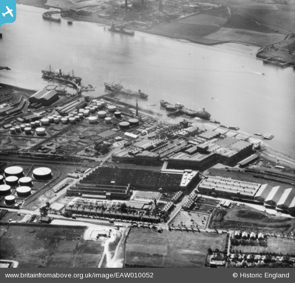
EAW010052 ENGLAND (1947). Thames Board Mills, Purfleet, 1947
© Copyright OpenStreetMap contributors and licensed by the OpenStreetMap Foundation. 2026. Cartography is licensed as CC BY-SA.
Nearby Images (31)
Details
| Title | [EAW010052] Thames Board Mills, Purfleet, 1947 |
| Reference | EAW010052 |
| Date | 6-September-1947 |
| Link | |
| Place name | PURFLEET |
| Parish | |
| District | |
| Country | ENGLAND |
| Easting / Northing | 555980, 177527 |
| Longitude / Latitude | 0.24623799091026, 51.474685380279 |
| National Grid Reference | TQ560775 |
Pins
Be the first to add a comment to this image!


![[EAW010052] Thames Board Mills, Purfleet, 1947](http://britainfromabove.org.uk/sites/all/libraries/aerofilms-images/public/100x100/EAW/010/EAW010052.jpg)
![[EAW024362] The Hunting and Son Ltd oil tanker "Edenfield" moored at the Esso pier, Purfleet, 1949](http://britainfromabove.org.uk/sites/all/libraries/aerofilms-images/public/100x100/EAW/024/EAW024362.jpg)
![[EPW011905] The Anglo-American Oil Co Ltd Works at Purfleet, Thurrock, 1924. This image has been produced from a print.](http://britainfromabove.org.uk/sites/all/libraries/aerofilms-images/public/100x100/EPW/011/EPW011905.jpg)
![[EAW010063] Thames Board Mills, Purfleet, 1947](http://britainfromabove.org.uk/sites/all/libraries/aerofilms-images/public/100x100/EAW/010/EAW010063.jpg)
![[EAW023047] A tanker moored at the Esso Oil Depot, Purfleet, 1949](http://britainfromabove.org.uk/sites/all/libraries/aerofilms-images/public/100x100/EAW/023/EAW023047.jpg)
![[EAW024361] The Hunting and Son Ltd oil tanker "Edenfield" moored at the Esso pier, Purfleet, 1949](http://britainfromabove.org.uk/sites/all/libraries/aerofilms-images/public/100x100/EAW/024/EAW024361.jpg)
![[EAW023164] Tanker moored by the Esso Oil Depot, Purfleet, 1949](http://britainfromabove.org.uk/sites/all/libraries/aerofilms-images/public/100x100/EAW/023/EAW023164.jpg)
![[EAW024364] The Hunting and Son Ltd oil tanker "Edenfield" moored at the Esso pier, Purfleet, from the south-west, 1949. This image was marked by Aerofilms Ltd for photo editing.](http://britainfromabove.org.uk/sites/all/libraries/aerofilms-images/public/100x100/EAW/024/EAW024364.jpg)
![[EAW010062] Thames Board Mills, Purfleet, 1947](http://britainfromabove.org.uk/sites/all/libraries/aerofilms-images/public/100x100/EAW/010/EAW010062.jpg)
![[EAW024366] The Hunting and Son Ltd oil tanker "Edenfield" moored at the Esso pier, Purfleet, 1949](http://britainfromabove.org.uk/sites/all/libraries/aerofilms-images/public/100x100/EAW/024/EAW024366.jpg)
![[EAW024365] The Hunting and Son Ltd oil tanker "Edenfield" moored at the Esso pier, Purfleet, 1949](http://britainfromabove.org.uk/sites/all/libraries/aerofilms-images/public/100x100/EAW/024/EAW024365.jpg)
![[EAW024368] The Hunting and Son Ltd oil tanker "Edenfield" moored at the Esso pier, Purfleet, 1949](http://britainfromabove.org.uk/sites/all/libraries/aerofilms-images/public/100x100/EAW/024/EAW024368.jpg)
![[EAW024367] The Hunting and Son Ltd oil tanker "Edenfield" moored at the Esso pier, Purfleet, 1949](http://britainfromabove.org.uk/sites/all/libraries/aerofilms-images/public/100x100/EAW/024/EAW024367.jpg)
![[EAW010050] Thames Board Mills, Purfleet, 1947. This image was marked by Aerofilms Ltd for photo editing.](http://britainfromabove.org.uk/sites/all/libraries/aerofilms-images/public/100x100/EAW/010/EAW010050.jpg)
![[EAW011781] Thames Board Mills and environs, Purfleet, 1947](http://britainfromabove.org.uk/sites/all/libraries/aerofilms-images/public/100x100/EAW/011/EAW011781.jpg)
![[EAW024360] The Hunting and Son Ltd oil tanker "Edenfield" moored at the Esso pier, Purfleet, 1949](http://britainfromabove.org.uk/sites/all/libraries/aerofilms-images/public/100x100/EAW/024/EAW024360.jpg)
![[EAW010053] Thames Board Mills and environs, Purfleet, 1947](http://britainfromabove.org.uk/sites/all/libraries/aerofilms-images/public/100x100/EAW/010/EAW010053.jpg)
![[EAW048218] Flooding at the Esso Petroleum Co Ltd Terminal, Purfleet, from the south-west, 1953](http://britainfromabove.org.uk/sites/all/libraries/aerofilms-images/public/100x100/EAW/048/EAW048218.jpg)
![[EAW024359] The Hunting and Son Ltd oil tanker "Edenfield" moored at the Esso pier, Purfleet, 1949. This image has been produced from a damaged negative.](http://britainfromabove.org.uk/sites/all/libraries/aerofilms-images/public/100x100/EAW/024/EAW024359.jpg)
![[EAW024363] The Hunting and Son Ltd oil tanker "Edenfield" moored at the Esso pier, Purfleet, 1949](http://britainfromabove.org.uk/sites/all/libraries/aerofilms-images/public/100x100/EAW/024/EAW024363.jpg)
![[EAW011785] Thames Board Mills and environs, Purfleet, 1947](http://britainfromabove.org.uk/sites/all/libraries/aerofilms-images/public/100x100/EAW/011/EAW011785.jpg)
![[EAW011779] Thames Board Mills, Purfleet, 1947](http://britainfromabove.org.uk/sites/all/libraries/aerofilms-images/public/100x100/EAW/011/EAW011779.jpg)
![[EAW010059] Thames Board Mills, Purfleet, 1947. This image was marked by Aerofilms Ltd for photo editing.](http://britainfromabove.org.uk/sites/all/libraries/aerofilms-images/public/100x100/EAW/010/EAW010059.jpg)
![[EAW024369] The Hunting and Son Ltd oil tanker "Edenfield" moored at the Esso pier, Purfleet, from the south-west, 1949](http://britainfromabove.org.uk/sites/all/libraries/aerofilms-images/public/100x100/EAW/024/EAW024369.jpg)
![[EAW010060] Thames Board Mills, Purfleet, 1947. This image was marked by Aerofilms Ltd for photo editing.](http://britainfromabove.org.uk/sites/all/libraries/aerofilms-images/public/100x100/EAW/010/EAW010060.jpg)
![[EAW011784] Thames Board Mills, Purfleet, 1947](http://britainfromabove.org.uk/sites/all/libraries/aerofilms-images/public/100x100/EAW/011/EAW011784.jpg)
![[EAW011780] Thames Board Mills and environs, Purfleet, 1947](http://britainfromabove.org.uk/sites/all/libraries/aerofilms-images/public/100x100/EAW/011/EAW011780.jpg)
![[EAW010061] Thames Board Mills, Purfleet, 1947. This image was marked by Aerofilms Ltd for photo editing.](http://britainfromabove.org.uk/sites/all/libraries/aerofilms-images/public/100x100/EAW/010/EAW010061.jpg)
![[EAW011783] Thames Board Mills, Purfleet, 1947](http://britainfromabove.org.uk/sites/all/libraries/aerofilms-images/public/100x100/EAW/011/EAW011783.jpg)
![[EAW010054] Thames Board Mills and environs, Purfleet, 1947. This image was marked by Aerofilms Ltd for photo editing.](http://britainfromabove.org.uk/sites/all/libraries/aerofilms-images/public/100x100/EAW/010/EAW010054.jpg)
![[EAW010058] Thames Board Mills, Purfleet, 1947. This image was marked by Aerofilms Ltd for photo editing.](http://britainfromabove.org.uk/sites/all/libraries/aerofilms-images/public/100x100/EAW/010/EAW010058.jpg)