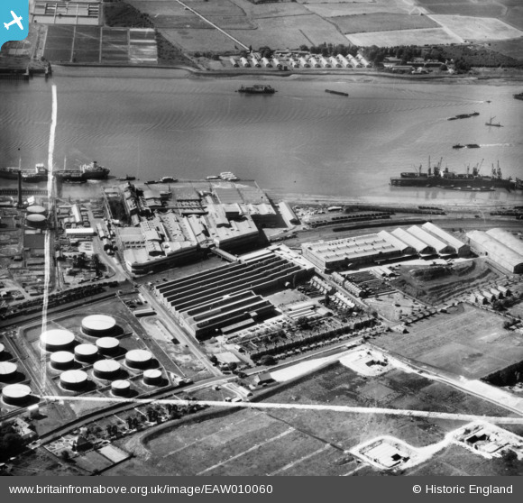
EAW010060 ENGLAND (1947). Thames Board Mills, Purfleet, 1947. This image was marked by Aerofilms Ltd for photo editing.
© Copyright OpenStreetMap contributors and licensed by the OpenStreetMap Foundation. 2026. Cartography is licensed as CC BY-SA.
Nearby Images (29)
Details
| Title | [EAW010060] Thames Board Mills, Purfleet, 1947. This image was marked by Aerofilms Ltd for photo editing. |
| Reference | EAW010060 |
| Date | 6-September-1947 |
| Link | |
| Place name | PURFLEET |
| Parish | |
| District | |
| Country | ENGLAND |
| Easting / Northing | 555872, 177715 |
| Longitude / Latitude | 0.24476694488235, 51.47640444948 |
| National Grid Reference | TQ559777 |
Pins

Kentishman |
Sunday 4th of September 2016 04:45:01 PM | |

Kentishman |
Sunday 4th of September 2016 04:42:01 PM |


![[EAW010060] Thames Board Mills, Purfleet, 1947. This image was marked by Aerofilms Ltd for photo editing.](http://britainfromabove.org.uk/sites/all/libraries/aerofilms-images/public/100x100/EAW/010/EAW010060.jpg)
![[EAW011784] Thames Board Mills, Purfleet, 1947](http://britainfromabove.org.uk/sites/all/libraries/aerofilms-images/public/100x100/EAW/011/EAW011784.jpg)
![[EAW011779] Thames Board Mills, Purfleet, 1947](http://britainfromabove.org.uk/sites/all/libraries/aerofilms-images/public/100x100/EAW/011/EAW011779.jpg)
![[EAW010061] Thames Board Mills, Purfleet, 1947. This image was marked by Aerofilms Ltd for photo editing.](http://britainfromabove.org.uk/sites/all/libraries/aerofilms-images/public/100x100/EAW/010/EAW010061.jpg)
![[EAW010050] Thames Board Mills, Purfleet, 1947. This image was marked by Aerofilms Ltd for photo editing.](http://britainfromabove.org.uk/sites/all/libraries/aerofilms-images/public/100x100/EAW/010/EAW010050.jpg)
![[EAW010064] Thames Board Mills, Purfleet, 1947. This image was marked by Aerofilms Ltd for photo editing.](http://britainfromabove.org.uk/sites/all/libraries/aerofilms-images/public/100x100/EAW/010/EAW010064.jpg)
![[EAW011783] Thames Board Mills, Purfleet, 1947](http://britainfromabove.org.uk/sites/all/libraries/aerofilms-images/public/100x100/EAW/011/EAW011783.jpg)
![[EAW011780] Thames Board Mills and environs, Purfleet, 1947](http://britainfromabove.org.uk/sites/all/libraries/aerofilms-images/public/100x100/EAW/011/EAW011780.jpg)
![[EAW011785] Thames Board Mills and environs, Purfleet, 1947](http://britainfromabove.org.uk/sites/all/libraries/aerofilms-images/public/100x100/EAW/011/EAW011785.jpg)
![[EAW010062] Thames Board Mills, Purfleet, 1947](http://britainfromabove.org.uk/sites/all/libraries/aerofilms-images/public/100x100/EAW/010/EAW010062.jpg)
![[EAW010053] Thames Board Mills and environs, Purfleet, 1947](http://britainfromabove.org.uk/sites/all/libraries/aerofilms-images/public/100x100/EAW/010/EAW010053.jpg)
![[EAW010059] Thames Board Mills, Purfleet, 1947. This image was marked by Aerofilms Ltd for photo editing.](http://britainfromabove.org.uk/sites/all/libraries/aerofilms-images/public/100x100/EAW/010/EAW010059.jpg)
![[EAW010054] Thames Board Mills and environs, Purfleet, 1947. This image was marked by Aerofilms Ltd for photo editing.](http://britainfromabove.org.uk/sites/all/libraries/aerofilms-images/public/100x100/EAW/010/EAW010054.jpg)
![[EAW011777] Thames Board Mills and environs, Purfleet, 1947](http://britainfromabove.org.uk/sites/all/libraries/aerofilms-images/public/100x100/EAW/011/EAW011777.jpg)
![[EAW011778] Thames Board Mills, Purfleet, 1947](http://britainfromabove.org.uk/sites/all/libraries/aerofilms-images/public/100x100/EAW/011/EAW011778.jpg)
![[EAW011781] Thames Board Mills and environs, Purfleet, 1947](http://britainfromabove.org.uk/sites/all/libraries/aerofilms-images/public/100x100/EAW/011/EAW011781.jpg)
![[EAW011782] Thames Board Mills and environs, Purfleet, 1947](http://britainfromabove.org.uk/sites/all/libraries/aerofilms-images/public/100x100/EAW/011/EAW011782.jpg)
![[EAW010058] Thames Board Mills, Purfleet, 1947. This image was marked by Aerofilms Ltd for photo editing.](http://britainfromabove.org.uk/sites/all/libraries/aerofilms-images/public/100x100/EAW/010/EAW010058.jpg)
![[EAW010063] Thames Board Mills, Purfleet, 1947](http://britainfromabove.org.uk/sites/all/libraries/aerofilms-images/public/100x100/EAW/010/EAW010063.jpg)
![[EAW010067] Thames Board Mills, Purfleet, 1947. This image was marked by Aerofilms for photo editing.](http://britainfromabove.org.uk/sites/all/libraries/aerofilms-images/public/100x100/EAW/010/EAW010067.jpg)
![[EAW011776] Thames Board Mills and environs, Purfleet, 1947](http://britainfromabove.org.uk/sites/all/libraries/aerofilms-images/public/100x100/EAW/011/EAW011776.jpg)
![[EAW010065] Thames Board Mills, Purfleet, 1947](http://britainfromabove.org.uk/sites/all/libraries/aerofilms-images/public/100x100/EAW/010/EAW010065.jpg)
![[EAW010055] Thames Board Mills, Purfleet, 1947. This image was marked by Aerofilms Ltd for photo editing.](http://britainfromabove.org.uk/sites/all/libraries/aerofilms-images/public/100x100/EAW/010/EAW010055.jpg)
![[EAW010057] Thames Board Mills and environs, Purfleet, 1947. This image was marked by Aerofilms Ltd for photo editing.](http://britainfromabove.org.uk/sites/all/libraries/aerofilms-images/public/100x100/EAW/010/EAW010057.jpg)
![[EAW010066] Thames Board Mills, Purfleet, 1947](http://britainfromabove.org.uk/sites/all/libraries/aerofilms-images/public/100x100/EAW/010/EAW010066.jpg)
![[EAW010052] Thames Board Mills, Purfleet, 1947](http://britainfromabove.org.uk/sites/all/libraries/aerofilms-images/public/100x100/EAW/010/EAW010052.jpg)
![[EAW010049] Thames Board Mills, Purfleet, 1947](http://britainfromabove.org.uk/sites/all/libraries/aerofilms-images/public/100x100/EAW/010/EAW010049.jpg)
![[EAW024362] The Hunting and Son Ltd oil tanker "Edenfield" moored at the Esso pier, Purfleet, 1949](http://britainfromabove.org.uk/sites/all/libraries/aerofilms-images/public/100x100/EAW/024/EAW024362.jpg)
![[EPW011905] The Anglo-American Oil Co Ltd Works at Purfleet, Thurrock, 1924. This image has been produced from a print.](http://britainfromabove.org.uk/sites/all/libraries/aerofilms-images/public/100x100/EPW/011/EPW011905.jpg)