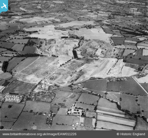
EAW011226 ENGLAND (1947). Opencast coal mining to the north of Heanor Road, Denby Village, 1947
© Copyright OpenStreetMap contributors and licensed by the OpenStreetMap Foundation. 2026. Cartography is licensed as CC BY-SA.
Nearby Images (34)
Details
| Title | [EAW011226] Opencast coal mining to the north of Heanor Road, Denby Village, 1947 |
| Reference | EAW011226 |
| Date | 30-September-1947 |
| Link | |
| Place name | DENBY VILLAGE |
| Parish | DENBY |
| District | |
| Country | ENGLAND |
| Easting / Northing | 441093, 345661 |
| Longitude / Latitude | -1.3875279285091, 53.006376166015 |
| National Grid Reference | SK411457 |


![[EAW011226] Opencast coal mining to the north of Heanor Road, Denby Village, 1947](http://britainfromabove.org.uk/sites/all/libraries/aerofilms-images/public/100x100/EAW/011/EAW011226.jpg)
![[EAW033469] Restored opencast mining site north of Carrington's Farm, Denby Village, 1950. This image was marked by Aerofilms Ltd for photo editing.](http://britainfromabove.org.uk/sites/all/libraries/aerofilms-images/public/100x100/EAW/033/EAW033469.jpg)
![[EAW011243] Opencast coal mining to the north of Carrington's Farm, Smalley, 1947](http://britainfromabove.org.uk/sites/all/libraries/aerofilms-images/public/100x100/EAW/011/EAW011243.jpg)
![[EAW011225] Opencast coal mining to the north of Heanor Road, Denby Village, 1947](http://britainfromabove.org.uk/sites/all/libraries/aerofilms-images/public/100x100/EAW/011/EAW011225.jpg)
![[EAW017986] Opencast coal mining, Smalley, 1948. This image has been produced from a print.](http://britainfromabove.org.uk/sites/all/libraries/aerofilms-images/public/100x100/EAW/017/EAW017986.jpg)
![[EAW033472] Restored opencast mining site near Carrington's Farm, Flamstead Plantation and environs, Denby Village, 1950](http://britainfromabove.org.uk/sites/all/libraries/aerofilms-images/public/100x100/EAW/033/EAW033472.jpg)
![[EAW011238] Opencast coal mining to the north of Carrington's Farm, Smalley, 1947](http://britainfromabove.org.uk/sites/all/libraries/aerofilms-images/public/100x100/EAW/011/EAW011238.jpg)
![[EAW033470] Restored opencast mining site north of Carrington's Farm, Denby Village, 1950. This image was marked by Aerofilms Ltd for photo editing.](http://britainfromabove.org.uk/sites/all/libraries/aerofilms-images/public/100x100/EAW/033/EAW033470.jpg)
![[EAW033471] Restored opencast mining site near Carrington's Farm, Denby Village, 1950. This image was marked by Aerofilms Ltd for photo editing.](http://britainfromabove.org.uk/sites/all/libraries/aerofilms-images/public/100x100/EAW/033/EAW033471.jpg)
![[EAW012039] Opencast mining site to the north of the village, Smalley, 1947. This image was marked by Aerofilms Ltd for photo editing.](http://britainfromabove.org.uk/sites/all/libraries/aerofilms-images/public/100x100/EAW/012/EAW012039.jpg)
![[EAW033474] Restored opencast mining site near Carrington's Farm, Denby Village, 1950](http://britainfromabove.org.uk/sites/all/libraries/aerofilms-images/public/100x100/EAW/033/EAW033474.jpg)
![[EAW011224] Opencast coal mining to the east of Flamstead Plantation, Denby Village, 1947](http://britainfromabove.org.uk/sites/all/libraries/aerofilms-images/public/100x100/EAW/011/EAW011224.jpg)
![[EAW033473] Restored opencast mining site near Carrington's Farm, Flamstead Plantation and environs, Denby Village, 1950](http://britainfromabove.org.uk/sites/all/libraries/aerofilms-images/public/100x100/EAW/033/EAW033473.jpg)
![[EAW011252] Opencast coal mining to the west of Kidsleypark Farm, Smalley, 1947](http://britainfromabove.org.uk/sites/all/libraries/aerofilms-images/public/100x100/EAW/011/EAW011252.jpg)
![[EAW012040] Opencast mining site to the north of the village, Smalley, 1947. This image was marked by Aerofilms Ltd for photo editing.](http://britainfromabove.org.uk/sites/all/libraries/aerofilms-images/public/100x100/EAW/012/EAW012040.jpg)
![[EAW012052] Opencast mining site to the north of the village, Smalley, 1947](http://britainfromabove.org.uk/sites/all/libraries/aerofilms-images/public/100x100/EAW/012/EAW012052.jpg)
![[EAW012042] Opencast mining site to the north of the village, Smalley, 1947. This image was marked by Aerofilms Ltd for photo editing.](http://britainfromabove.org.uk/sites/all/libraries/aerofilms-images/public/100x100/EAW/012/EAW012042.jpg)
![[EAW012041] Opencast mining site to the north of the village, Smalley, 1947. This image was marked by Aerofilms Ltd for photo editing.](http://britainfromabove.org.uk/sites/all/libraries/aerofilms-images/public/100x100/EAW/012/EAW012041.jpg)
![[EAW025912] An opencast mining site adjacent to Heanor Road, Smalley, 1949](http://britainfromabove.org.uk/sites/all/libraries/aerofilms-images/public/100x100/EAW/025/EAW025912.jpg)
![[EAW018400] An opencast mining site to the north of the village, Smalley, from the west, 1948](http://britainfromabove.org.uk/sites/all/libraries/aerofilms-images/public/100x100/EAW/018/EAW018400.jpg)
![[EAW011235] Opencast coal mining to the north of Carrington's Farm, Smalley, 1947](http://britainfromabove.org.uk/sites/all/libraries/aerofilms-images/public/100x100/EAW/011/EAW011235.jpg)
![[EAW011236] Opencast coal mining to the north of Carrington's Farm, Smalley, 1947](http://britainfromabove.org.uk/sites/all/libraries/aerofilms-images/public/100x100/EAW/011/EAW011236.jpg)
![[EAW025916] An opencast mining site adjacent to Heanor Road, Smalley, from the north-west, 1949](http://britainfromabove.org.uk/sites/all/libraries/aerofilms-images/public/100x100/EAW/025/EAW025916.jpg)
![[EAW017964] Opencast coal mining to the north of Carrington's Farm, Smalley, 1948. This image has been produced from a damaged negative.](http://britainfromabove.org.uk/sites/all/libraries/aerofilms-images/public/100x100/EAW/017/EAW017964.jpg)
![[EAW018415] An opencast mining site to the north of the village, Smalley, from the north-west, 1948](http://britainfromabove.org.uk/sites/all/libraries/aerofilms-images/public/100x100/EAW/018/EAW018415.jpg)
![[EAW017963] Opencast coal mining to the north of Carrington's Farm, Smalley, 1948. This image has been produced from a damaged negative.](http://britainfromabove.org.uk/sites/all/libraries/aerofilms-images/public/100x100/EAW/017/EAW017963.jpg)
![[EAW011237] Opencast coal mining to the north of Carrington's Farm, Smalley, 1947](http://britainfromabove.org.uk/sites/all/libraries/aerofilms-images/public/100x100/EAW/011/EAW011237.jpg)
![[EAW017958] Opencast coal mining to the north of Carrington's Farm, Denby Village, 1948. This image has been produced from a damaged negative.](http://britainfromabove.org.uk/sites/all/libraries/aerofilms-images/public/100x100/EAW/017/EAW017958.jpg)
![[EAW025921] An opencast mining site adjacent to Heanor Road, Smalley, 1949. This image has been produced from a print.](http://britainfromabove.org.uk/sites/all/libraries/aerofilms-images/public/100x100/EAW/025/EAW025921.jpg)
![[EAW018404] An opencast mining site to the north of the village, Smalley, 1948](http://britainfromabove.org.uk/sites/all/libraries/aerofilms-images/public/100x100/EAW/018/EAW018404.jpg)
![[EAW012044] Opencast mining site to the north of the village, Smalley, 1947. This image was marked by Aerofilms Ltd for photo editing.](http://britainfromabove.org.uk/sites/all/libraries/aerofilms-images/public/100x100/EAW/012/EAW012044.jpg)
![[EAW018405] An opencast mining site to the north of the village, Smalley, 1948](http://britainfromabove.org.uk/sites/all/libraries/aerofilms-images/public/100x100/EAW/018/EAW018405.jpg)
![[EAW018411] A Rapier crane at an opencast mining site to the north of the village, Smalley, from the north, 1948](http://britainfromabove.org.uk/sites/all/libraries/aerofilms-images/public/100x100/EAW/018/EAW018411.jpg)
![[EAW018403] An opencast mining site to the north of the village, Smalley, 1948](http://britainfromabove.org.uk/sites/all/libraries/aerofilms-images/public/100x100/EAW/018/EAW018403.jpg)
