
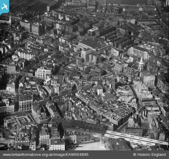
EAW004895 ENGLAND (1947). Fenchurch Street and environs including bomb damage and cleared ground, London, 1947
© Copyright OpenStreetMap contributors and licensed by the OpenStreetMap Foundation. 2026. Cartography is licensed as CC BY-SA.
Nearby Images (15)
EAW004895

EAW011375

EAW011172

EAW021724

EAW011145

EAW011376

EAW011146

EAW048559

EPW045403

EAW011171

EPW045383

EAW011195
, Bury Street and environs, London, 1947")
EAW004896

EAW011144

EAW035188

Details
| Title | [EAW004895] Fenchurch Street and environs including bomb damage and cleared ground, London, 1947 |
| Reference | EAW004895 |
| Date | April-1947 |
| Link | |
| Place name | LONDON |
| Parish | |
| District | |
| Country | ENGLAND |
| Easting / Northing | 533455, 181133 |
| Longitude / Latitude | -0.076563300764054, 51.512857381427 |
| National Grid Reference | TQ335811 |
Pins

Robin |
Saturday 5th of July 2025 12:38:33 AM | |
|
Robin |
Saturday 5th of July 2025 12:36:09 AM | |

Alan McFaden |
Sunday 11th of January 2015 10:39:23 AM | |
|
Alan McFaden |
Sunday 11th of January 2015 10:37:57 AM | |

Class31 |
Friday 13th of June 2014 08:47:18 AM | |
|
Class31 |
Friday 13th of June 2014 08:46:54 AM | |
|
Class31 |
Friday 13th of June 2014 08:46:22 AM | |
|
Class31 |
Friday 13th of June 2014 08:46:04 AM | |
|
Class31 |
Thursday 12th of June 2014 10:32:09 AM | |
|
Class31 |
Thursday 12th of June 2014 10:31:50 AM | |
|
Alan McFaden |
Sunday 12th of January 2014 08:17:50 PM | |
|
Alan McFaden |
Thursday 24th of October 2013 10:27:26 AM | |
|
Alan McFaden |
Thursday 29th of August 2013 12:46:47 PM |


User Comment Contributions

Spitalfields Market |
Alan McFaden |
Sunday 11th of January 2015 10:40:07 AM |