
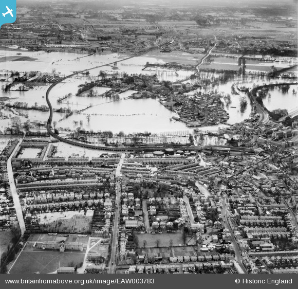
EAW003783 ENGLAND (1947). Flooding at Windsor and Eton centred upon The Brocas, Windsor, 1947
© Copyright OpenStreetMap contributors and licensed by the OpenStreetMap Foundation. 2026. Cartography is licensed as CC BY-SA.
Nearby Images (5)
EAW003783

EAW003702

EAW003782

EAW042131

EPW053889

Details
| Title | [EAW003783] Flooding at Windsor and Eton centred upon The Brocas, Windsor, 1947 |
| Reference | EAW003783 |
| Date | 19-March-1947 |
| Link | |
| Place name | WINDSOR |
| Parish | |
| District | |
| Country | ENGLAND |
| Easting / Northing | 496399, 177114 |
| Longitude / Latitude | -0.61153466253576, 51.484267546949 |
| National Grid Reference | SU964771 |
Pins

Matt Aldred edob.mattaldred.com |
Tuesday 7th of July 2026 04:57:47 PM | |
|
Matt Aldred edob.mattaldred.com |
Tuesday 7th of July 2026 04:57:34 PM | |
|
Matt Aldred edob.mattaldred.com |
Tuesday 7th of July 2026 04:57:25 PM | |

Thamesweb |
Thursday 8th of February 2024 10:37:35 PM | |
|
Thamesweb |
Thursday 8th of February 2024 10:35:25 PM | |
|
Thamesweb |
Sunday 15th of December 2013 11:40:00 AM | |
|
Thamesweb |
Sunday 15th of December 2013 12:11:24 AM |