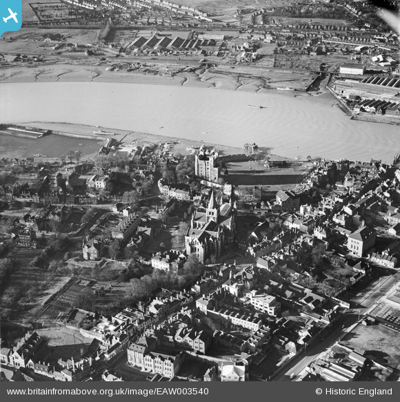
EAW003540 ENGLAND (1947). Rochester Castle, the Cathedral and environs, Rochester, 1947
© Copyright OpenStreetMap contributors and licensed by the OpenStreetMap Foundation. 2026. Cartography is licensed as CC BY-SA.
Nearby Images (26)
Details
| Title | [EAW003540] Rochester Castle, the Cathedral and environs, Rochester, 1947 |
| Reference | EAW003540 |
| Date | 16-January-1947 |
| Link | |
| Place name | ROCHESTER |
| Parish | |
| District | |
| Country | ENGLAND |
| Easting / Northing | 574167, 168541 |
| Longitude / Latitude | 0.50347127436896, 51.388648493909 |
| National Grid Reference | TQ742685 |
Pins

Kizle7 |
Thursday 17th of July 2025 12:09:25 AM | |

Kizle7 |
Monday 31st of July 2023 11:34:21 PM | |

Kizle7 |
Monday 31st of July 2023 11:33:19 PM | |

Sparky |
Tuesday 22nd of August 2017 10:34:57 PM | |

Sparky |
Tuesday 22nd of August 2017 10:34:07 PM | |

Kentishman |
Sunday 6th of March 2016 06:00:46 PM | |

JimP |
Monday 16th of February 2015 02:24:36 PM | |

David Hill |
Tuesday 31st of December 2013 09:34:56 AM |


![[EAW003540] Rochester Castle, the Cathedral and environs, Rochester, 1947](http://britainfromabove.org.uk/sites/all/libraries/aerofilms-images/public/100x100/EAW/003/EAW003540.jpg)
![[EAW017035] Rochester Castle and environs, Rochester, from the west, 1948. This image has been produced from a damaged negative.](http://britainfromabove.org.uk/sites/all/libraries/aerofilms-images/public/100x100/EAW/017/EAW017035.jpg)
![[EAW004795] Rochester Castle and the Cathedral, Rochester, 1947. This image has been produced from a print.](http://britainfromabove.org.uk/sites/all/libraries/aerofilms-images/public/100x100/EAW/004/EAW004795.jpg)
![[EAW003543] Rochester Castle, the Cathedral and environs, Rochester, from the north-west, 1947](http://britainfromabove.org.uk/sites/all/libraries/aerofilms-images/public/100x100/EAW/003/EAW003543.jpg)
![[EAW004791] Rochester Castle and Castle Gardens, Rochester, 1947](http://britainfromabove.org.uk/sites/all/libraries/aerofilms-images/public/100x100/EAW/004/EAW004791.jpg)
![[EAW017033] The castle gardens, town and the River Medway, Rochester, from the north-east, 1948. This image has been produced from a damaged negative.](http://britainfromabove.org.uk/sites/all/libraries/aerofilms-images/public/100x100/EAW/017/EAW017033.jpg)
![[EAW004793] Rochester Castle and Rochester Bridge, Rochester, from the south-east, 1947. This image has been produced from a print.](http://britainfromabove.org.uk/sites/all/libraries/aerofilms-images/public/100x100/EAW/004/EAW004793.jpg)
![[EAW004794] Rochester Castle and Castle Gardens, Rochester, 1947](http://britainfromabove.org.uk/sites/all/libraries/aerofilms-images/public/100x100/EAW/004/EAW004794.jpg)
![[EAW004792] Rochester Castle and Castle Gardens, Rochester, 1947. This image has been produced from a print.](http://britainfromabove.org.uk/sites/all/libraries/aerofilms-images/public/100x100/EAW/004/EAW004792.jpg)
![[EAW017034] Rochester Castle, Rochester, 1948. This image has been produced from a damaged negative.](http://britainfromabove.org.uk/sites/all/libraries/aerofilms-images/public/100x100/EAW/017/EAW017034.jpg)
![[EAW004845] Rochester Castle, the Castle Gardens and environs, Rochester, 1947. This image has been produced from a print.](http://britainfromabove.org.uk/sites/all/libraries/aerofilms-images/public/100x100/EAW/004/EAW004845.jpg)
![[EAW004796] Rochester Cathedral, Rochester, 1947](http://britainfromabove.org.uk/sites/all/libraries/aerofilms-images/public/100x100/EAW/004/EAW004796.jpg)
![[EAW017032] Rochester Castle (site of), town and the River Medway, Rochester, 1948. This image has been produced from a damaged negative.](http://britainfromabove.org.uk/sites/all/libraries/aerofilms-images/public/100x100/EAW/017/EAW017032.jpg)
![[EAW018579] Rochester City Walls, the High Street, Cathedral and Castle, Rochester, 1948. This image was marked by Aerofilms Ltd for photo editing.](http://britainfromabove.org.uk/sites/all/libraries/aerofilms-images/public/100x100/EAW/018/EAW018579.jpg)
![[EAW003542] Rochester Castle, the Cathedral and environs, Rochester, from the south-east, 1947](http://britainfromabove.org.uk/sites/all/libraries/aerofilms-images/public/100x100/EAW/003/EAW003542.jpg)
![[EAW017036] Rochester Castle, Rochester Bridge and the River Medway, Rochester, 1948. This image has been produced from a damaged negative.](http://britainfromabove.org.uk/sites/all/libraries/aerofilms-images/public/100x100/EAW/017/EAW017036.jpg)
![[EAW003539] Rochester Castle, the Cathedral and environs, Rochester, 1947](http://britainfromabove.org.uk/sites/all/libraries/aerofilms-images/public/100x100/EAW/003/EAW003539.jpg)
![[EAW003541] Rochester Cathedral and environs, Rochester, 1947](http://britainfromabove.org.uk/sites/all/libraries/aerofilms-images/public/100x100/EAW/003/EAW003541.jpg)
![[EAW018573] The High Street, Cathedral and Castle, Rochester, 1948. This image has been produced from a print marked by Aerofilms Ltd for photo editing.](http://britainfromabove.org.uk/sites/all/libraries/aerofilms-images/public/100x100/EAW/018/EAW018573.jpg)
![[EAW018575] The High Street, King's School and the Castle Rochester, 1948. This image has been produced from a print.](http://britainfromabove.org.uk/sites/all/libraries/aerofilms-images/public/100x100/EAW/018/EAW018575.jpg)
![[EAW018572] The High Street, Cathedral and Castle, Rochester, 1948. This image has been produced from a print marked by Aerofilms Ltd for photo editing.](http://britainfromabove.org.uk/sites/all/libraries/aerofilms-images/public/100x100/EAW/018/EAW018572.jpg)
![[EAW018577] The High Street, King's School and environs, Rochester, 1948. This image has been produced from a print marked by Aerofilms Ltd for photo editing.](http://britainfromabove.org.uk/sites/all/libraries/aerofilms-images/public/100x100/EAW/018/EAW018577.jpg)
![[EAW017031] Rochester Castle alongside the River Medway, Rochester, 1948. This image has been produced from a print.](http://britainfromabove.org.uk/sites/all/libraries/aerofilms-images/public/100x100/EAW/017/EAW017031.jpg)
![[EAW018578] The High Street, Maidstone Road and environs, Rochester, from the north, 1948. This image has been produced from a print marked by Aerofilms Ltd for photo editing.](http://britainfromabove.org.uk/sites/all/libraries/aerofilms-images/public/100x100/EAW/018/EAW018578.jpg)
![[EAW018574] The High Street and Maidstone Road, Rochester, 1948. This image has been produced from a print marked by Aerofilms Ltd for photo editing.](http://britainfromabove.org.uk/sites/all/libraries/aerofilms-images/public/100x100/EAW/018/EAW018574.jpg)
![[EAW018576] The High Street and Maidstone Road, Rochester, 1948. This image has been produced from a print marked by Aerofilms Ltd for photo editing.](http://britainfromabove.org.uk/sites/all/libraries/aerofilms-images/public/100x100/EAW/018/EAW018576.jpg)