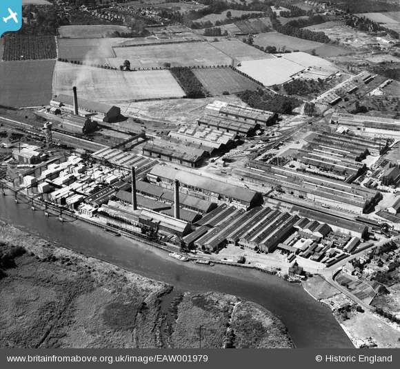
EAW001979 ENGLAND (1946). Aylesford Paper Mills, Ditton, 1946
© Copyright OpenStreetMap contributors and licensed by the OpenStreetMap Foundation. 2026. Cartography is licensed as CC BY-SA.
Nearby Images (18)
Details
| Title | [EAW001979] Aylesford Paper Mills, Ditton, 1946 |
| Reference | EAW001979 |
| Date | 25-July-1946 |
| Link | |
| Place name | DITTON |
| Parish | DITTON |
| District | |
| Country | ENGLAND |
| Easting / Northing | 571331, 159729 |
| Longitude / Latitude | 0.45850440085613, 51.310341019546 |
| National Grid Reference | TQ713597 |
Pins

Matt Aldred edob.mattaldred.com |
Saturday 28th of October 2023 12:02:02 PM |


![[EAW001979] Aylesford Paper Mills, Ditton, 1946](http://britainfromabove.org.uk/sites/all/libraries/aerofilms-images/public/100x100/EAW/001/EAW001979.jpg)
![[EPW045997] Aylesford Paper Mill, Ditton, 1934](http://britainfromabove.org.uk/sites/all/libraries/aerofilms-images/public/100x100/EPW/045/EPW045997.jpg)
![[EAW001975] Aylesford Paper Mills, Ditton, 1946](http://britainfromabove.org.uk/sites/all/libraries/aerofilms-images/public/100x100/EAW/001/EAW001975.jpg)
![[EAW001976] Aylesford Paper Mills, Ditton, 1946](http://britainfromabove.org.uk/sites/all/libraries/aerofilms-images/public/100x100/EAW/001/EAW001976.jpg)
![[EPW045998] Aylesford Paper Mill, Ditton, 1934](http://britainfromabove.org.uk/sites/all/libraries/aerofilms-images/public/100x100/EPW/045/EPW045998.jpg)
![[EAW018286] The Aylesford Paper Mills, Ditton, from the north-east, 1948. This image has been produced from a print marked by Aerofilms Ltd for photo editing.](http://britainfromabove.org.uk/sites/all/libraries/aerofilms-images/public/100x100/EAW/018/EAW018286.jpg)
![[EAW001973] Aylesford Paper Mills, Ditton, 1946](http://britainfromabove.org.uk/sites/all/libraries/aerofilms-images/public/100x100/EAW/001/EAW001973.jpg)
![[EPW046000] Aylesford Paper Mill, Ditton, 1934](http://britainfromabove.org.uk/sites/all/libraries/aerofilms-images/public/100x100/EPW/046/EPW046000.jpg)
![[EPW045999] Aylesford Paper Mill, Ditton, 1934](http://britainfromabove.org.uk/sites/all/libraries/aerofilms-images/public/100x100/EPW/045/EPW045999.jpg)
![[EPW047728] Aylesford Paper Mills, Ditton, 1935](http://britainfromabove.org.uk/sites/all/libraries/aerofilms-images/public/100x100/EPW/047/EPW047728.jpg)
![[EPW047727] Aylesford Paper Mills, Ditton, 1935](http://britainfromabove.org.uk/sites/all/libraries/aerofilms-images/public/100x100/EPW/047/EPW047727.jpg)
![[EAW018288] The Aylesford Paper Mills, Ditton, from the north-east, 1948. This image has been produced from a print marked by Aerofilms Ltd for photo editing.](http://britainfromabove.org.uk/sites/all/libraries/aerofilms-images/public/100x100/EAW/018/EAW018288.jpg)
![[EAW001974] Aylesford Paper Mills, Ditton, from the north-east, 1946](http://britainfromabove.org.uk/sites/all/libraries/aerofilms-images/public/100x100/EAW/001/EAW001974.jpg)
![[EAW018287] The Aylesford Paper Mills, Ditton, from the north-east, 1948. This image has been produced from a print marked by Aerofilms Ltd for photo editing.](http://britainfromabove.org.uk/sites/all/libraries/aerofilms-images/public/100x100/EAW/018/EAW018287.jpg)
![[EPW046002] Aylesford Paper Mill, Ditton, 1934](http://britainfromabove.org.uk/sites/all/libraries/aerofilms-images/public/100x100/EPW/046/EPW046002.jpg)
![[EAW001977] Aylesford Paper Mills, Ditton, from the north-east, 1946](http://britainfromabove.org.uk/sites/all/libraries/aerofilms-images/public/100x100/EAW/001/EAW001977.jpg)
![[EPW046001] Aylesford Paper Mill, Ditton, 1934](http://britainfromabove.org.uk/sites/all/libraries/aerofilms-images/public/100x100/EPW/046/EPW046001.jpg)
![[EAW001980] Aylesford Paper Mills, Ditton, 1946](http://britainfromabove.org.uk/sites/all/libraries/aerofilms-images/public/100x100/EAW/001/EAW001980.jpg)