
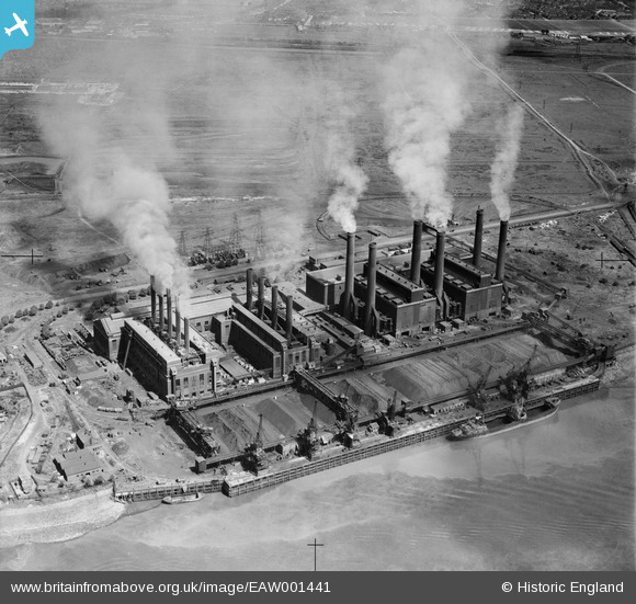
EAW001441 ENGLAND (1946). Barking Power Station, Creekmouth, 1946
© Copyright OpenStreetMap contributors and licensed by the OpenStreetMap Foundation. 2026. Cartography is licensed as CC BY-SA.
Nearby Images (33)
EAW001441

EPW012743

EPW010666

EPW009692

EPW009691

EPW009688

EPW009685

EPW009689

EPW009687

EPW032828

EPW012739

EPW009686

EPW009690

EPW010661

EPW012740

EPW010662

EPW010667

EPW010665

EPW021371

EPW008725

EPW036789

EPW009666

EPW012742

EPW010671

EPW008727

EPW032829

EPW010668

EPW008726

EPW008728

EPW010669

EPW010670

EPW008729

EPW010663

Details
| Title | [EAW001441] Barking Power Station, Creekmouth, 1946 |
| Reference | EAW001441 |
| Date | 3-July-1946 |
| Link | |
| Place name | CREEKMOUTH |
| Parish | |
| District | |
| Country | ENGLAND |
| Easting / Northing | 546485, 181841 |
| Longitude / Latitude | 0.11139639211323, 51.515991325712 |
| National Grid Reference | TQ465818 |
Pins

Dylan Moore |
Wednesday 16th of July 2014 05:28:15 PM | |
|
Dylan Moore |
Wednesday 16th of July 2014 05:26:42 PM | |

MB |
Tuesday 5th of November 2013 12:38:17 PM | |
|
MB |
Tuesday 5th of November 2013 12:37:10 PM | |
|
MB |
Tuesday 5th of November 2013 12:34:42 PM | |
|
MB |
Tuesday 5th of November 2013 11:23:41 AM | |
|
MB |
Tuesday 5th of November 2013 11:22:25 AM | |
|
MB |
Tuesday 5th of November 2013 11:20:49 AM | |
|
MB |
Tuesday 5th of November 2013 11:19:40 AM | |
|
MB |
Tuesday 5th of November 2013 11:16:49 AM | |
|
MB |
Saturday 14th of September 2013 02:39:42 PM |
User Comment Contributions
I think this view shows the A and the B power stations. Coal was delivered by rail as well as by sea. A cable tunnel under the Thames also delivered power to communities in Kent. See Wikipedia for more information: en.wikipedia.org/wiki/Barking_Power_Station |
MB |
Tuesday 5th of November 2013 12:30:15 PM |