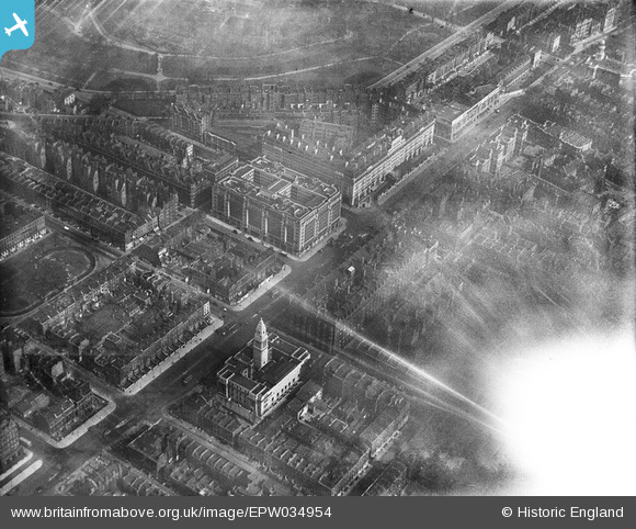
EPW034954 ENGLAND (1931). Berkeley Court, Westminster Council House and environs, Marylebone, 1931
© Copyright OpenStreetMap contributors and licensed by the OpenStreetMap Foundation. 2024. Cartography is licensed as CC BY-SA.
Nearby Images (22)
Details
| Title | [EPW034954] Berkeley Court, Westminster Council House and environs, Marylebone, 1931 |
| Reference | EPW034954 |
| Date | April-1931 |
| Link | |
| Place name | MARYLEBONE |
| Parish | |
| District | |
| Country | ENGLAND |
| Easting / Northing | 527872, 181966 |
| Longitude / Latitude | -0.15668092092988, 51.521635680484 |
| National Grid Reference | TQ279820 |


![[EPW034954] Berkeley Court, Westminster Council House and environs, Marylebone, 1931](http://britainfromabove.org.uk/sites/all/libraries/aerofilms-images/public/100x100/EPW/034/EPW034954.jpg)
![[EPW034958] Berkeley Court, Baker Street and environs, Marylebone, 1931](http://britainfromabove.org.uk/sites/all/libraries/aerofilms-images/public/100x100/EPW/034/EPW034958.jpg)
![[EPW034995] Westminster Council House, Berkeley Court, Regent's Park and environs, Marylebone, 1931](http://britainfromabove.org.uk/sites/all/libraries/aerofilms-images/public/100x100/EPW/034/EPW034995.jpg)
![[EPW034953] Berkeley Court and environs, Marylebone, 1931](http://britainfromabove.org.uk/sites/all/libraries/aerofilms-images/public/100x100/EPW/034/EPW034953.jpg)
![[EPW034996] Westminster Council House, Berkeley Court, Marylebone Road and environs, Marylebone, 1931](http://britainfromabove.org.uk/sites/all/libraries/aerofilms-images/public/100x100/EPW/034/EPW034996.jpg)
![[EPW034991] Westminster Council House, Berkeley Court, Regent's Park and environs, Marylebone, 1931](http://britainfromabove.org.uk/sites/all/libraries/aerofilms-images/public/100x100/EPW/034/EPW034991.jpg)
![[EPW034957] Berkeley Court, Westminster Council House and environs, Marylebone, 1931](http://britainfromabove.org.uk/sites/all/libraries/aerofilms-images/public/100x100/EPW/034/EPW034957.jpg)
![[EPW034990] Berkeley Court, Marylebone Road and environs, Marylebone, 1931](http://britainfromabove.org.uk/sites/all/libraries/aerofilms-images/public/100x100/EPW/034/EPW034990.jpg)
![[EPW034994] Marylebone Road, Berkeley Court, Regent's College and environs, Marylebone, 1931](http://britainfromabove.org.uk/sites/all/libraries/aerofilms-images/public/100x100/EPW/034/EPW034994.jpg)
![[EPW034956] Berkeley Court, Westminster Council House and environs, Marylebone, 1931](http://britainfromabove.org.uk/sites/all/libraries/aerofilms-images/public/100x100/EPW/034/EPW034956.jpg)
![[EPW034992] Baker Street, Berkeley Court, Regent's College and environs, Marylebone, 1931](http://britainfromabove.org.uk/sites/all/libraries/aerofilms-images/public/100x100/EPW/034/EPW034992.jpg)
![[EPW034955] Berkeley Court, Baker Street Station and environs, Marylebone, 1931](http://britainfromabove.org.uk/sites/all/libraries/aerofilms-images/public/100x100/EPW/034/EPW034955.jpg)
![[EPW034993] St Mary's Church, Marylebone Road, Berkeley Court and environs, Marylebone, 1931](http://britainfromabove.org.uk/sites/all/libraries/aerofilms-images/public/100x100/EPW/034/EPW034993.jpg)
![[EPW044586] Marble Arch, Regent's Park and Marylebone, Westminster, 1934](http://britainfromabove.org.uk/sites/all/libraries/aerofilms-images/public/100x100/EPW/044/EPW044586.jpg)
![[EPW008740] Madame Tussaud and Sons' Exhibition, Baker Street Station and environs, Regent's Park, 1923. This image has been produced from a print.](http://britainfromabove.org.uk/sites/all/libraries/aerofilms-images/public/100x100/EPW/008/EPW008740.jpg)
