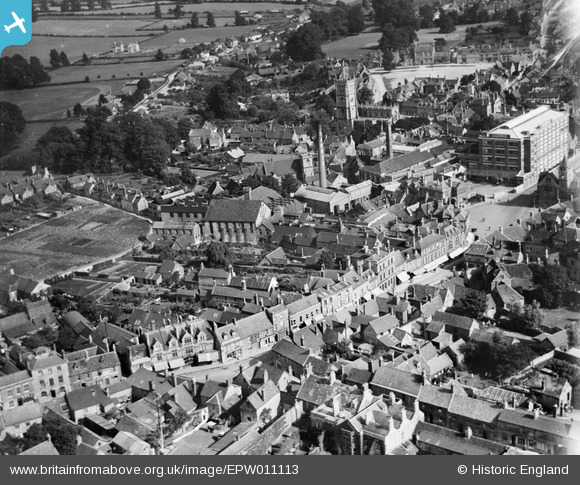
EPW011113 ENGLAND (1924). The Harris Bacon Factory and the High Street, Calne, 1924
© Copyright OpenStreetMap contributors and licensed by the OpenStreetMap Foundation. 2024. Cartography is licensed as CC BY-SA.
Nearby Images (24)
Details
| Title | [EPW011113] The Harris Bacon Factory and the High Street, Calne, 1924 |
| Reference | EPW011113 |
| Date | July-1924 |
| Link | |
| Place name | CALNE |
| Parish | CALNE |
| District | |
| Country | ENGLAND |
| Easting / Northing | 399790, 171074 |
| Longitude / Latitude | -2.0030215848894, 51.438171537966 |
| National Grid Reference | ST998711 |
Pins
Be the first to add a comment to this image!


![[EPW011113] The Harris Bacon Factory and the High Street, Calne, 1924](http://britainfromabove.org.uk/sites/all/libraries/aerofilms-images/public/100x100/EPW/011/EPW011113.jpg)
![[EPW033517] The Harris Bacon Factory and the town, Calne, 1930](http://britainfromabove.org.uk/sites/all/libraries/aerofilms-images/public/100x100/EPW/033/EPW033517.jpg)
![[EPW033518] The High Street, Calne, 1930](http://britainfromabove.org.uk/sites/all/libraries/aerofilms-images/public/100x100/EPW/033/EPW033518.jpg)
![[EPW033526] The town centre, Calne, 1930](http://britainfromabove.org.uk/sites/all/libraries/aerofilms-images/public/100x100/EPW/033/EPW033526.jpg)
![[EPW033516] The Harris Bacon Factory and the town centre, Calne, 1930](http://britainfromabove.org.uk/sites/all/libraries/aerofilms-images/public/100x100/EPW/033/EPW033516.jpg)
![[EPW011112] The Harris Bacon Factory and The Strand, Calne, 1924](http://britainfromabove.org.uk/sites/all/libraries/aerofilms-images/public/100x100/EPW/011/EPW011112.jpg)
![[EPW029293] The Harris Bacon Factory, High Street and The Strand, Calne, 1929](http://britainfromabove.org.uk/sites/all/libraries/aerofilms-images/public/100x100/EPW/029/EPW029293.jpg)
![[EPR000046] C. and T. Harris (Calne) Ltd Bacon Factory and the town centre, Calne, 1934](http://britainfromabove.org.uk/sites/all/libraries/aerofilms-images/public/100x100/EPR/000/EPR000046.jpg)
![[EPR000048] C. and T. Harris (Calne) Ltd Bacon Factory and the town centre, Calne, 1934](http://britainfromabove.org.uk/sites/all/libraries/aerofilms-images/public/100x100/EPR/000/EPR000048.jpg)
![[EPW033515] The Harris Bacon Factory and the town, Calne, 1930](http://britainfromabove.org.uk/sites/all/libraries/aerofilms-images/public/100x100/EPW/033/EPW033515.jpg)
![[EPW029300] The Harris Bacon Factory, the Town Hall and Market Hill, Calne, 1929](http://britainfromabove.org.uk/sites/all/libraries/aerofilms-images/public/100x100/EPW/029/EPW029300.jpg)
![[EPR000047] C. and T. Harris (Calne) Ltd Bacon Factory and the town centre, Calne, 1934](http://britainfromabove.org.uk/sites/all/libraries/aerofilms-images/public/100x100/EPR/000/EPR000047.jpg)
![[EPW001116] The Harris Bacon Factory and St Mary's Church, Calne, 1920](http://britainfromabove.org.uk/sites/all/libraries/aerofilms-images/public/100x100/EPW/001/EPW001116.jpg)
![[EPW011115] The Harris Bacon Factory, Calne, 1924](http://britainfromabove.org.uk/sites/all/libraries/aerofilms-images/public/100x100/EPW/011/EPW011115.jpg)
![[EPW029297] The Harris Bacon Factory, Calne, 1929](http://britainfromabove.org.uk/sites/all/libraries/aerofilms-images/public/100x100/EPW/029/EPW029297.jpg)
![[EPW029289] The Harris Bacon Factory and the town, Calne, 1929](http://britainfromabove.org.uk/sites/all/libraries/aerofilms-images/public/100x100/EPW/029/EPW029289.jpg)
![[EPW029302] The Harris Bacon Factory, St Mary's Church and the town, Calne, 1929](http://britainfromabove.org.uk/sites/all/libraries/aerofilms-images/public/100x100/EPW/029/EPW029302.jpg)
![[EPW029299] Housing off Wood Street and Curzon Street, Calne, 1929](http://britainfromabove.org.uk/sites/all/libraries/aerofilms-images/public/100x100/EPW/029/EPW029299.jpg)
![[EPW033520] Kingsbury Green and environs, Calne, 1930](http://britainfromabove.org.uk/sites/all/libraries/aerofilms-images/public/100x100/EPW/033/EPW033520.jpg)
![[EPW029294] The Harris Bacon Factory, St Mary's Church and the town, Calne, 1929](http://britainfromabove.org.uk/sites/all/libraries/aerofilms-images/public/100x100/EPW/029/EPW029294.jpg)
![[EPW033521] St Mary's Church and environs, Calne, 1930](http://britainfromabove.org.uk/sites/all/libraries/aerofilms-images/public/100x100/EPW/033/EPW033521.jpg)
![[EPW029298] Housing surrounding the junction of Wood Street and Oxford Road, Calne, 1929](http://britainfromabove.org.uk/sites/all/libraries/aerofilms-images/public/100x100/EPW/029/EPW029298.jpg)
![[EPW029296] St Mary's Church and Kingsbury Green, Calne, 1929](http://britainfromabove.org.uk/sites/all/libraries/aerofilms-images/public/100x100/EPW/029/EPW029296.jpg)
![[EPW029288] Kingsbury Green, St Mary's Church and the Harris Bacon Factory, Calne, 1929](http://britainfromabove.org.uk/sites/all/libraries/aerofilms-images/public/100x100/EPW/029/EPW029288.jpg)