
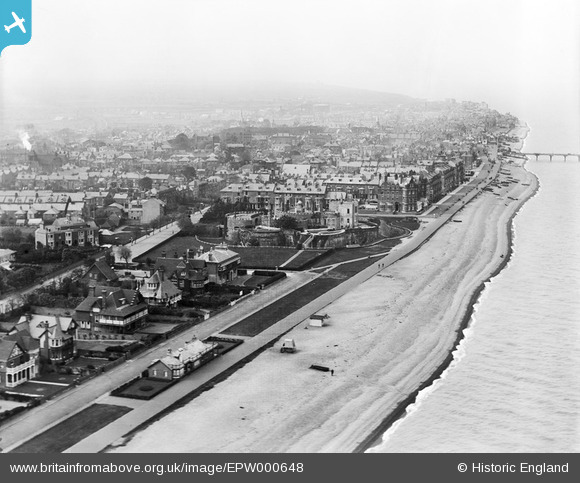
EPW000648 ENGLAND (1920). Deal Castle, Deal, from the south-east, 1920
© Copyright OpenStreetMap contributors and licensed by the OpenStreetMap Foundation. 2024. Cartography is licensed as CC BY-SA.
Nearby Images (17)
EPW000648

EPW042833

EPW000647

EPW035435

EPW009182

EPW035432

EPW000333

EPW035438

EPW019062

EAW014343

EAW014346

EAW014344

EPW000640

EPW019059

EAW014345

EAW014342

EPW035434

Details
| Title | [EPW000648] Deal Castle, Deal, from the south-east, 1920 |
| Reference | EPW000648 |
| Date | April-1920 |
| Link | |
| Place name | DEAL |
| Parish | WALMER |
| District | |
| Country | ENGLAND |
| Easting / Northing | 637813, 152030 |
| Longitude / Latitude | 1.4058074473667, 51.217338847179 |
| National Grid Reference | TR378520 |
Pins
 Alan McFaden |
Wednesday 9th of July 2014 11:11:31 AM | |
Alan McFaden |
Wednesday 9th of July 2014 11:11:03 AM | |
Alan McFaden |
Wednesday 9th of July 2014 11:10:38 AM | |
Alan McFaden |
Wednesday 9th of July 2014 11:10:05 AM |


