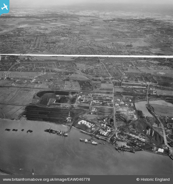
EAW046778 ENGLAND (1952). The jetties, depots and industrial premises at Horse Shoe Corner, Dagenham, from the south, 1952. This image was marked by Aerofilms Ltd for photo editing.
© Copyright OpenStreetMap contributors and licensed by the OpenStreetMap Foundation. 2024. Cartography is licensed as CC BY-SA.
Nearby Images (42)
Details
| Title | [EAW046778] The jetties, depots and industrial premises at Horse Shoe Corner, Dagenham, from the south, 1952. This image was marked by Aerofilms Ltd for photo editing. |
| Reference | EAW046778 |
| Date | 13-September-1952 |
| Link | |
| Place name | DAGENHAM |
| Parish | |
| District | |
| Country | ENGLAND |
| Easting / Northing | 548652, 182143 |
| Longitude / Latitude | 0.14273503270461, 51.518139014937 |
| National Grid Reference | TQ487821 |
Pins
Be the first to add a comment to this image!


![[EAW046778] The jetties, depots and industrial premises at Horse Shoe Corner, Dagenham, from the south, 1952. This image was marked by Aerofilms Ltd for photo editing.](http://britainfromabove.org.uk/sites/all/libraries/aerofilms-images/public/100x100/EAW/046/EAW046778.jpg)
![[EAW046780] The jetties, depots and industrial premises at Horse Shoe Corner, Dagenham, 1952. This image was marked by Aerofilms Ltd for photo editing.](http://britainfromabove.org.uk/sites/all/libraries/aerofilms-images/public/100x100/EAW/046/EAW046780.jpg)
![[EAW046771] The jetties, depots and industrial premises at Horse Shoe Corner, Dagenham, from the south-east, 1952. This image was marked by Aerofilms Ltd for photo editing.](http://britainfromabove.org.uk/sites/all/libraries/aerofilms-images/public/100x100/EAW/046/EAW046771.jpg)
![[EAW031163] The fuel storage depot beside Dagenham Dock, Dagenham, 1950. This image was marked by Aerofilms Ltd for photo editing.](http://britainfromabove.org.uk/sites/all/libraries/aerofilms-images/public/100x100/EAW/031/EAW031163.jpg)
![[EAW031159] The fuel storage depot beside Dagenham Dock, Dagenham, 1950. This image was marked by Aerofilms Ltd for photo editing.](http://britainfromabove.org.uk/sites/all/libraries/aerofilms-images/public/100x100/EAW/031/EAW031159.jpg)
![[EAW031166] The fuel storage depot beside Dagenham Dock, Dagenham, 1950](http://britainfromabove.org.uk/sites/all/libraries/aerofilms-images/public/100x100/EAW/031/EAW031166.jpg)
![[EAW031165] The fuel storage depot beside Dagenham Dock, Dagenham, 1950. This image was marked by Aerofilms Ltd for photo editing.](http://britainfromabove.org.uk/sites/all/libraries/aerofilms-images/public/100x100/EAW/031/EAW031165.jpg)
![[EPW021395] The Solvent Products Works, Dagenham, 1928](http://britainfromabove.org.uk/sites/all/libraries/aerofilms-images/public/100x100/EPW/021/EPW021395.jpg)
![[EAW046775] The jetties, depots and industrial premises at Horse Shoe Corner, Dagenham, from the south-east, 1952. This image was marked by Aerofilms Ltd for photo editing.](http://britainfromabove.org.uk/sites/all/libraries/aerofilms-images/public/100x100/EAW/046/EAW046775.jpg)
![[EPW046552] The Solvent Products Ltd Works, Dagenham, 1935](http://britainfromabove.org.uk/sites/all/libraries/aerofilms-images/public/100x100/EPW/046/EPW046552.jpg)
![[EPW046548] The Solvent Products Ltd Works, Dagenham, 1935](http://britainfromabove.org.uk/sites/all/libraries/aerofilms-images/public/100x100/EPW/046/EPW046548.jpg)
![[EPW021391] The Solvent Products Works, Dagenham, 1928](http://britainfromabove.org.uk/sites/all/libraries/aerofilms-images/public/100x100/EPW/021/EPW021391.jpg)
![[EPW046547] The Solvent Products Ltd Works, Dagenham, 1935](http://britainfromabove.org.uk/sites/all/libraries/aerofilms-images/public/100x100/EPW/046/EPW046547.jpg)
![[EPW046614] The Solvent Products Works and environs, Dagenham, 1935](http://britainfromabove.org.uk/sites/all/libraries/aerofilms-images/public/100x100/EPW/046/EPW046614.jpg)
![[EPW046515] The Solvent Products Ltd Works, Dagenham, 1935](http://britainfromabove.org.uk/sites/all/libraries/aerofilms-images/public/100x100/EPW/046/EPW046515.jpg)
![[EAW031160] A pylon beside the jetty at Horse Shoe Corner, Dagenham, 1950. This image was marked by Aerofilms Ltd for photo editing.](http://britainfromabove.org.uk/sites/all/libraries/aerofilms-images/public/100x100/EAW/031/EAW031160.jpg)
![[EPW009946] Factories and piers at Chequers Lane, Dagenham, 1924](http://britainfromabove.org.uk/sites/all/libraries/aerofilms-images/public/100x100/EPW/009/EPW009946.jpg)
![[EAW046774] The jetties, depots and industrial premises at Horse Shoe Corner, Dagenham, 1952. This image was marked by Aerofilms Ltd for photo editing.](http://britainfromabove.org.uk/sites/all/libraries/aerofilms-images/public/100x100/EAW/046/EAW046774.jpg)
![[EPW046553] The Solvent Products Ltd Works, Dagenham, 1935](http://britainfromabove.org.uk/sites/all/libraries/aerofilms-images/public/100x100/EPW/046/EPW046553.jpg)
![[EPW046546] Dagenham Dock, Dagenham Marshes and the Solvent Products Ltd Works, Dagenham, 1935](http://britainfromabove.org.uk/sites/all/libraries/aerofilms-images/public/100x100/EPW/046/EPW046546.jpg)
![[EPW046550] The Solvent Products Ltd Works, Dagenham, 1935](http://britainfromabove.org.uk/sites/all/libraries/aerofilms-images/public/100x100/EPW/046/EPW046550.jpg)
![[EPW021396] The Solvent Products Works, Dagenham, 1928](http://britainfromabove.org.uk/sites/all/libraries/aerofilms-images/public/100x100/EPW/021/EPW021396.jpg)
![[EPW021394] The Solvent Products Works, Dagenham, 1928](http://britainfromabove.org.uk/sites/all/libraries/aerofilms-images/public/100x100/EPW/021/EPW021394.jpg)
![[EPW046549] The Solvent Products Ltd Works, Dagenham, 1935](http://britainfromabove.org.uk/sites/all/libraries/aerofilms-images/public/100x100/EPW/046/EPW046549.jpg)
![[EPW046615] The Solvent Products Works, Dagenham, 1935](http://britainfromabove.org.uk/sites/all/libraries/aerofilms-images/public/100x100/EPW/046/EPW046615.jpg)
![[EAW046777] The jetties, depots and industrial premises at Horse Shoe Corner, Dagenham, from the south, 1952](http://britainfromabove.org.uk/sites/all/libraries/aerofilms-images/public/100x100/EAW/046/EAW046777.jpg)
![[EPW009947] Dagenham Dock and the River Thames, Dagenham, from the north-west, 1924](http://britainfromabove.org.uk/sites/all/libraries/aerofilms-images/public/100x100/EPW/009/EPW009947.jpg)
![[EPW046551] Dagenham Docks, the Dagenham Marshes and the Solvent Products Ltd Works, Dagenham, 1935](http://britainfromabove.org.uk/sites/all/libraries/aerofilms-images/public/100x100/EPW/046/EPW046551.jpg)
![[EPW046613] The Solvent Products Works and environs, Dagenham, 1935](http://britainfromabove.org.uk/sites/all/libraries/aerofilms-images/public/100x100/EPW/046/EPW046613.jpg)
![[EPW046612] The Solvent Products Works, Dagenham, 1935](http://britainfromabove.org.uk/sites/all/libraries/aerofilms-images/public/100x100/EPW/046/EPW046612.jpg)
![[EPW021393] The Solvent Products Works, Dagenham, 1928](http://britainfromabove.org.uk/sites/all/libraries/aerofilms-images/public/100x100/EPW/021/EPW021393.jpg)
![[EPW021389] The Solvent Products Works, Dagenham, 1928](http://britainfromabove.org.uk/sites/all/libraries/aerofilms-images/public/100x100/EPW/021/EPW021389.jpg)
![[EPW009951] Dagenham Dock and factories on Chequers Lane, Dagenham, 1924](http://britainfromabove.org.uk/sites/all/libraries/aerofilms-images/public/100x100/EPW/009/EPW009951.jpg)
![[EPW021398] The Solvent Products Works and works off Chequers Lane, Dagenham, 1928](http://britainfromabove.org.uk/sites/all/libraries/aerofilms-images/public/100x100/EPW/021/EPW021398.jpg)
![[EPW059965] The Texaco Oil Depot off Chequers Lane, Dagenham, 1938](http://britainfromabove.org.uk/sites/all/libraries/aerofilms-images/public/100x100/EPW/059/EPW059965.jpg)
![[EAW031164] Horse Shoe Corner, Dagenham, 1950. This image was marked by Aerofilms Ltd for photo editing.](http://britainfromabove.org.uk/sites/all/libraries/aerofilms-images/public/100x100/EAW/031/EAW031164.jpg)
![[EPW059964] The Texaco Oil Depot off Chequers Lane, Dagenham, 1938](http://britainfromabove.org.uk/sites/all/libraries/aerofilms-images/public/100x100/EPW/059/EPW059964.jpg)
![[EPW021397] The Solvent Products Works, Dagenham, 1928](http://britainfromabove.org.uk/sites/all/libraries/aerofilms-images/public/100x100/EPW/021/EPW021397.jpg)
![[EAW031156] The jetty at Horse Shoe Corner, Dagenham, 1950. This image was marked by Aerofilms Ltd for photo editing.](http://britainfromabove.org.uk/sites/all/libraries/aerofilms-images/public/100x100/EAW/031/EAW031156.jpg)
![[EPW059966] The Texaco Oil Depot off Chequers Lane, Dagenham, 1938](http://britainfromabove.org.uk/sites/all/libraries/aerofilms-images/public/100x100/EPW/059/EPW059966.jpg)
![[EPW059963] The Texaco Oil Depot off Chequers Lane, Dagenham, 1938](http://britainfromabove.org.uk/sites/all/libraries/aerofilms-images/public/100x100/EPW/059/EPW059963.jpg)
![[EPW059967] The Texaco Oil Depot off Chequers Lane, Dagenham, 1938. This image has been produced from a damaged negative.](http://britainfromabove.org.uk/sites/all/libraries/aerofilms-images/public/100x100/EPW/059/EPW059967.jpg)


