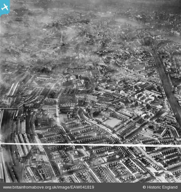
EAW041819 ENGLAND (1952). Grange Road and environs, Bermondsey, 1952. This image was marked by Aerofilms Ltd for photo editing.
© Copyright OpenStreetMap contributors and licensed by the OpenStreetMap Foundation. 2024. Cartography is licensed as CC BY-SA.
Nearby Images (18)
Details
| Title | [EAW041819] Grange Road and environs, Bermondsey, 1952. This image was marked by Aerofilms Ltd for photo editing. |
| Reference | EAW041819 |
| Date | 5-March-1952 |
| Link | |
| Place name | BERMONDSEY |
| Parish | |
| District | |
| Country | ENGLAND |
| Easting / Northing | 533633, 179084 |
| Longitude / Latitude | -0.074775854931967, 51.494400080468 |
| National Grid Reference | TQ336791 |
Pins
 Class31 |
Sunday 5th of October 2014 11:48:36 AM | |
 Class31 |
Saturday 26th of July 2014 10:37:47 PM | |
 Alan McFaden |
Wednesday 14th of May 2014 09:43:25 AM | |
 Alan McFaden |
Wednesday 14th of May 2014 09:42:19 AM | |
 Alan McFaden |
Wednesday 14th of May 2014 09:40:17 AM | |
 Alan McFaden |
Wednesday 14th of May 2014 09:39:04 AM | |
 Alan McFaden |
Wednesday 14th of May 2014 09:37:25 AM | |
 Chelsea61 |
Thursday 1st of May 2014 06:45:51 PM |
User Comment Contributions
 Saint Mary Magdelen Church Bermondsey |
 Alan McFaden |
Sunday 2nd of November 2014 09:30:15 AM |
Neckinger Mills, Abbey Street, 30/09/2014 |
 Class31 |
Sunday 5th of October 2014 11:47:23 AM |


![[EAW041819] Grange Road and environs, Bermondsey, 1952. This image was marked by Aerofilms Ltd for photo editing.](http://britainfromabove.org.uk/sites/all/libraries/aerofilms-images/public/100x100/EAW/041/EAW041819.jpg)
![[EAW041821] Southwark Park Road, Grange Road and environs, Bermondsey, 1952. This image has been produced from a print marked by Aerofilms Ltd for photo editing.](http://britainfromabove.org.uk/sites/all/libraries/aerofilms-images/public/100x100/EAW/041/EAW041821.jpg)
![[EAW041815] Grange Road and environs, Bermondsey, 1952. This image was marked by Aerofilms Ltd for photo editing.](http://britainfromabove.org.uk/sites/all/libraries/aerofilms-images/public/100x100/EAW/041/EAW041815.jpg)
![[EAW041826] Southwark Park Road, Grange Road and environs, Bermondsey, 1952. This image has been produced from a print marked by Aerofilms Ltd for photo editing.](http://britainfromabove.org.uk/sites/all/libraries/aerofilms-images/public/100x100/EAW/041/EAW041826.jpg)
![[EAW041813] Grange Road and environs, Bermondsey, 1952. This image was marked by Aerofilms Ltd for photo editing.](http://britainfromabove.org.uk/sites/all/libraries/aerofilms-images/public/100x100/EAW/041/EAW041813.jpg)
![[EAW041822] Grange Road and environs, Bermondsey, 1952. This image has been produced from a print marked by Aerofilms Ltd for photo editing.](http://britainfromabove.org.uk/sites/all/libraries/aerofilms-images/public/100x100/EAW/041/EAW041822.jpg)
![[EAW041818] Grange Road and environs, Bermondsey, 1952. This image was marked by Aerofilms Ltd for photo editing.](http://britainfromabove.org.uk/sites/all/libraries/aerofilms-images/public/100x100/EAW/041/EAW041818.jpg)
![[EAW041814] Grange Road and environs, Bermondsey, 1952. This image was marked by Aerofilms Ltd for photo editing.](http://britainfromabove.org.uk/sites/all/libraries/aerofilms-images/public/100x100/EAW/041/EAW041814.jpg)
![[EAW041824] Grange Road and environs, Bermondsey, 1952. This image has been produced from a print marked by Aerofilms Ltd for photo editing.](http://britainfromabove.org.uk/sites/all/libraries/aerofilms-images/public/100x100/EAW/041/EAW041824.jpg)
![[EAW041816] Grange Road and environs, Bermondsey, 1952. This image was marked by Aerofilms Ltd for photo editing.](http://britainfromabove.org.uk/sites/all/libraries/aerofilms-images/public/100x100/EAW/041/EAW041816.jpg)
![[EAW041825] Southwark Park Road, Grange Road and environs, Bermondsey, 1952. This image has been produced from a print marked by Aerofilms Ltd for photo editing.](http://britainfromabove.org.uk/sites/all/libraries/aerofilms-images/public/100x100/EAW/041/EAW041825.jpg)
![[EPW055345] A cityscape over Bermondsey looking towards Southwark Park, Bermondsey, 1937](http://britainfromabove.org.uk/sites/all/libraries/aerofilms-images/public/100x100/EPW/055/EPW055345.jpg)
![[EAW041823] Grange Road and environs, Bermondsey, 1952. This image has been produced from a print marked by Aerofilms Ltd for photo editing.](http://britainfromabove.org.uk/sites/all/libraries/aerofilms-images/public/100x100/EAW/041/EAW041823.jpg)
![[EAW041817] Grange Road and environs, Bermondsey, 1952. This image was marked by Aerofilms Ltd for photo editing.](http://britainfromabove.org.uk/sites/all/libraries/aerofilms-images/public/100x100/EAW/041/EAW041817.jpg)
![[EAW041820] Grange Road and environs, Bermondsey, 1952. This image has been produced from a print marked by Aerofilms Ltd for photo editing.](http://britainfromabove.org.uk/sites/all/libraries/aerofilms-images/public/100x100/EAW/041/EAW041820.jpg)
![[EAW036366] Southwark Park Road, Eonia Soap Works and environs, Bermondsey, 1951. This image has been produced from a print marked by Aerofilms Ltd for photo editing.](http://britainfromabove.org.uk/sites/all/libraries/aerofilms-images/public/100x100/EAW/036/EAW036366.jpg)
![[EAW036365] Alscot Road, Eonia Soap Works and environs, Bermondsey, 1951. This image has been produced from a print marked by Aerofilms Ltd for photo editing.](http://britainfromabove.org.uk/sites/all/libraries/aerofilms-images/public/100x100/EAW/036/EAW036365.jpg)
![[EAW036361] Southwark Park Road, the Eonia Soap Works and environs, Bermondsey, 1951. This image has been produced from a print marked by Aerofilms Ltd for photo editing.](http://britainfromabove.org.uk/sites/all/libraries/aerofilms-images/public/100x100/EAW/036/EAW036361.jpg)


