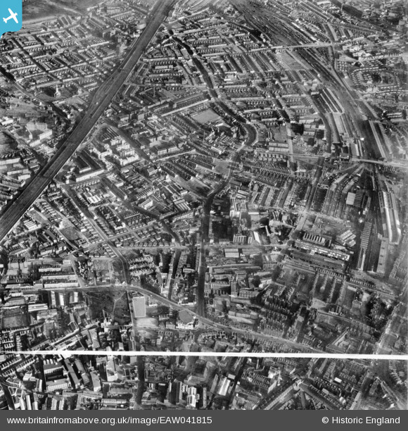
EAW041815 ENGLAND (1952). Grange Road and environs, Bermondsey, 1952. This image was marked by Aerofilms Ltd for photo editing.
© Copyright OpenStreetMap contributors and licensed by the OpenStreetMap Foundation. 2024. Cartography is licensed as CC BY-SA.
Nearby Images (15)
Details
| Title | [EAW041815] Grange Road and environs, Bermondsey, 1952. This image was marked by Aerofilms Ltd for photo editing. |
| Reference | EAW041815 |
| Date | 5-March-1952 |
| Link | |
| Place name | BERMONDSEY |
| Parish | |
| District | |
| Country | ENGLAND |
| Easting / Northing | 533587, 179130 |
| Longitude / Latitude | -0.075420749549963, 51.494824375667 |
| National Grid Reference | TQ336791 |
Pins
 Class31 |
Tuesday 12th of August 2014 04:57:33 PM | |
 Class31 |
Saturday 26th of July 2014 10:32:46 PM | |
 Class31 |
Saturday 26th of July 2014 10:31:45 PM | |
Neckinger Mills, Abbey Street, |
 Class31 |
Sunday 5th of October 2014 11:53:43 AM |
 Alan McFaden |
Monday 16th of June 2014 12:14:56 PM |
User Comment Contributions
 Saint James Church |
 Alan McFaden |
Sunday 2nd of November 2014 09:39:42 AM |
St. Mary Magdalen Church, Bermondsey, 30/09/2014 |
 Class31 |
Sunday 5th of October 2014 01:10:36 PM |
Neckinger Mills, Abbey Street, 30/09/2014 |
 Class31 |
Sunday 5th of October 2014 11:54:12 AM |
St. Mary Magdalen Church, Bermondsey, 30/09/2014 |
 Class31 |
Sunday 5th of October 2014 11:52:26 AM |


![[EAW041815] Grange Road and environs, Bermondsey, 1952. This image was marked by Aerofilms Ltd for photo editing.](http://britainfromabove.org.uk/sites/all/libraries/aerofilms-images/public/100x100/EAW/041/EAW041815.jpg)
![[EAW041813] Grange Road and environs, Bermondsey, 1952. This image was marked by Aerofilms Ltd for photo editing.](http://britainfromabove.org.uk/sites/all/libraries/aerofilms-images/public/100x100/EAW/041/EAW041813.jpg)
![[EAW041818] Grange Road and environs, Bermondsey, 1952. This image was marked by Aerofilms Ltd for photo editing.](http://britainfromabove.org.uk/sites/all/libraries/aerofilms-images/public/100x100/EAW/041/EAW041818.jpg)
![[EAW041819] Grange Road and environs, Bermondsey, 1952. This image was marked by Aerofilms Ltd for photo editing.](http://britainfromabove.org.uk/sites/all/libraries/aerofilms-images/public/100x100/EAW/041/EAW041819.jpg)
![[EAW041821] Southwark Park Road, Grange Road and environs, Bermondsey, 1952. This image has been produced from a print marked by Aerofilms Ltd for photo editing.](http://britainfromabove.org.uk/sites/all/libraries/aerofilms-images/public/100x100/EAW/041/EAW041821.jpg)
![[EAW041824] Grange Road and environs, Bermondsey, 1952. This image has been produced from a print marked by Aerofilms Ltd for photo editing.](http://britainfromabove.org.uk/sites/all/libraries/aerofilms-images/public/100x100/EAW/041/EAW041824.jpg)
![[EAW041817] Grange Road and environs, Bermondsey, 1952. This image was marked by Aerofilms Ltd for photo editing.](http://britainfromabove.org.uk/sites/all/libraries/aerofilms-images/public/100x100/EAW/041/EAW041817.jpg)
![[EAW041823] Grange Road and environs, Bermondsey, 1952. This image has been produced from a print marked by Aerofilms Ltd for photo editing.](http://britainfromabove.org.uk/sites/all/libraries/aerofilms-images/public/100x100/EAW/041/EAW041823.jpg)
![[EAW041814] Grange Road and environs, Bermondsey, 1952. This image was marked by Aerofilms Ltd for photo editing.](http://britainfromabove.org.uk/sites/all/libraries/aerofilms-images/public/100x100/EAW/041/EAW041814.jpg)
![[EAW041826] Southwark Park Road, Grange Road and environs, Bermondsey, 1952. This image has been produced from a print marked by Aerofilms Ltd for photo editing.](http://britainfromabove.org.uk/sites/all/libraries/aerofilms-images/public/100x100/EAW/041/EAW041826.jpg)
![[EAW041822] Grange Road and environs, Bermondsey, 1952. This image has been produced from a print marked by Aerofilms Ltd for photo editing.](http://britainfromabove.org.uk/sites/all/libraries/aerofilms-images/public/100x100/EAW/041/EAW041822.jpg)
![[EAW041816] Grange Road and environs, Bermondsey, 1952. This image was marked by Aerofilms Ltd for photo editing.](http://britainfromabove.org.uk/sites/all/libraries/aerofilms-images/public/100x100/EAW/041/EAW041816.jpg)
![[EAW041820] Grange Road and environs, Bermondsey, 1952. This image has been produced from a print marked by Aerofilms Ltd for photo editing.](http://britainfromabove.org.uk/sites/all/libraries/aerofilms-images/public/100x100/EAW/041/EAW041820.jpg)
![[EPW055345] A cityscape over Bermondsey looking towards Southwark Park, Bermondsey, 1937](http://britainfromabove.org.uk/sites/all/libraries/aerofilms-images/public/100x100/EPW/055/EPW055345.jpg)
![[EAW041825] Southwark Park Road, Grange Road and environs, Bermondsey, 1952. This image has been produced from a print marked by Aerofilms Ltd for photo editing.](http://britainfromabove.org.uk/sites/all/libraries/aerofilms-images/public/100x100/EAW/041/EAW041825.jpg)
