
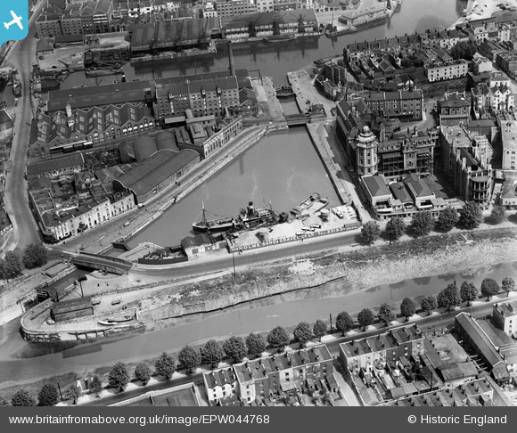
EPW044768 ENGLAND (1934). The Bathurst Basin, Holms Sand and Gravel Co Ltd and environs, Bristol, 1934
© Hawlfraint cyfranwyr OpenStreetMap a thrwyddedwyd gan yr OpenStreetMap Foundation. 2024. Trwyddedir y gartograffeg fel CC BY-SA.
Delweddau cyfagos (16)
EPW044768

EPW044770

EPW044772

EPW044771

EPW044769

EPW044774

EPW044773

EAW586137

EPW005436

EPW005437

EPW005434

EPW005438

EPW005435

EPW005433

EAW033320

EAW209373

Manylion
| Pennawd | [EPW044768] The Bathurst Basin, Holms Sand and Gravel Co Ltd and environs, Bristol, 1934 |
| Cyfeirnod | EPW044768 |
| Dyddiad | June-1934 |
| Dolen | |
| Enw lle | BRISTOL |
| Plwyf | |
| Ardal | |
| Gwlad | ENGLAND |
| Dwyreiniad / Gogleddiad | 358756, 172137 |
| Hydred / Lledred | -2.593546058808, 51.446228344874 |
| Cyfeirnod Grid Cenedlaethol | ST588721 |
Pinnau
 SmithyT |
Tuesday 14th of November 2017 03:05:59 PM | |
 Class31 |
Wednesday 26th of February 2014 02:32:30 PM | |
MB |
Wednesday 18th of September 2013 10:27:23 AM | |
MB |
Wednesday 18th of September 2013 10:26:06 AM | |
MB |
Wednesday 18th of September 2013 10:25:39 AM | |
MB |
Wednesday 18th of September 2013 10:25:14 AM | |
MB |
Wednesday 18th of September 2013 10:24:38 AM | |
Tiny Tim |
Thursday 18th of July 2013 05:25:58 PM | |
I think you will find this is a "swing" bridge. A bascule bridge is one that rises by filling a counter balance with water. https://en.wikipedia.org/wiki/Bascule_bridge |
John Wass |
Friday 27th of October 2017 07:28:14 PM |
Tiny Tim |
Thursday 18th of July 2013 05:25:13 PM | |
Tiny Tim |
Thursday 18th of July 2013 05:24:28 PM |
Cyfraniadau Grŵp
 Bathurst Basin 20/2/2014 |
Class31 |
Wednesday 26th of February 2014 02:41:47 PM |


