
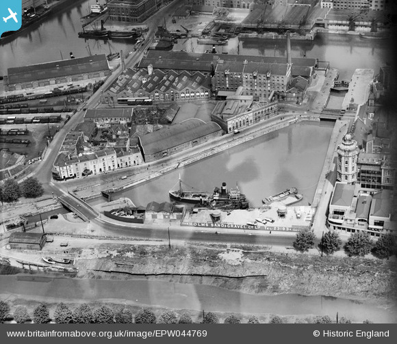
EPW044769 ENGLAND (1934). Bathurst Parade, the Bathurst Basin, Holms Sand and Gravel Co Ltd and environs, Bristol, 1934
© Hawlfraint cyfranwyr OpenStreetMap a thrwyddedwyd gan yr OpenStreetMap Foundation. 2024. Trwyddedir y gartograffeg fel CC BY-SA.
Delweddau cyfagos (16)
EPW044769

EPW044771

EPW044768

EPW044770

EPW044772

EPW044774

EPW044773

EAW586137

EPW005436

EPW005437

EPW005434

EPW005438

EPW005435

EPW005433

EAW209373

EAW033320

Manylion
| Pennawd | [EPW044769] Bathurst Parade, the Bathurst Basin, Holms Sand and Gravel Co Ltd and environs, Bristol, 1934 |
| Cyfeirnod | EPW044769 |
| Dyddiad | June-1934 |
| Dolen | |
| Enw lle | BRISTOL |
| Plwyf | |
| Ardal | |
| Gwlad | ENGLAND |
| Dwyreiniad / Gogleddiad | 358727, 172171 |
| Hydred / Lledred | -2.5939673429272, 51.446531963082 |
| Cyfeirnod Grid Cenedlaethol | ST587722 |
Pinnau


Cyfraniadau Grŵp
 Bathurst Basin 20/2/2014 |
 Class31 |
Wednesday 26th of February 2014 02:37:53 PM |


