
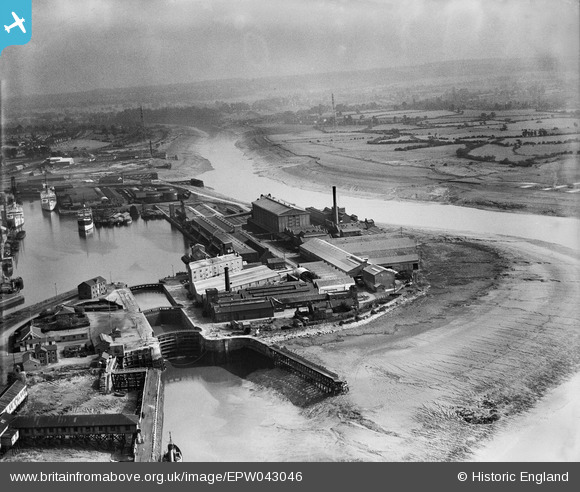
EPW043046 ENGLAND (1933). The granaries on Nelson Point beside Avonmouth Dock, Avonmouth, from the north-west, 1933
© Hawlfraint cyfranwyr OpenStreetMap a thrwyddedwyd gan yr OpenStreetMap Foundation. 2024. Trwyddedir y gartograffeg fel CC BY-SA.
Delweddau cyfagos (14)
EPW043046

EPW043049

EPW005517

EPW043047

EPW043045

EPW043048

EPW008651

EPW027948

EPW046969

EPW005488

EPW043044

EPW005525

EPW014691

EPW027950

Manylion
| Pennawd | [EPW043046] The granaries on Nelson Point beside Avonmouth Dock, Avonmouth, from the north-west, 1933 |
| Cyfeirnod | EPW043046 |
| Dyddiad | September-1933 |
| Dolen | |
| Enw lle | AVONMOUTH |
| Plwyf | |
| Ardal | |
| Gwlad | ENGLAND |
| Dwyreiniad / Gogleddiad | 350899, 178135 |
| Hydred / Lledred | -2.7074420736943, 51.499534652433 |
| Cyfeirnod Grid Cenedlaethol | ST509781 |
Pinnau
 MB |
Saturday 20th of August 2016 04:42:15 PM |