
Scheduled Maintenance
This website will undergo scheduled maintenance on Tuesday, September 10th, between 11:00 and 15:00, as well as on Thursday, September 12th, between 10:00 and 12:00. During this time, services may be temporarily disrupted. We apologise for any inconvenience.
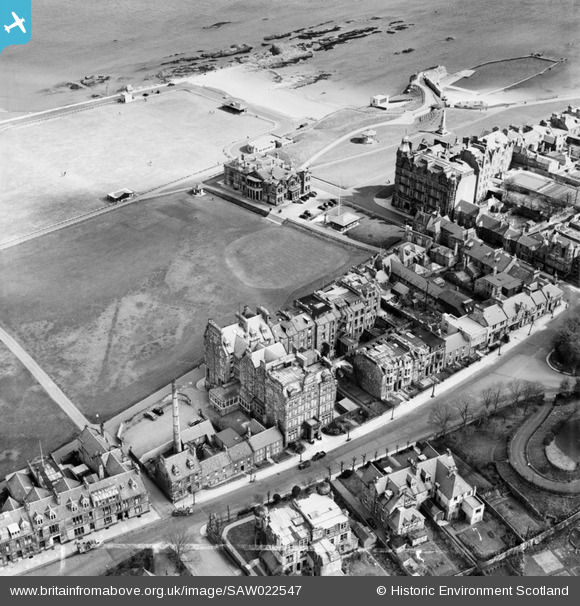
saw022547 SCOTLAND (1949). St Andrews, general view, showing Rusack's Hotel, Pilmour Links and Royal and Ancient Golf Club, Golf Place. An oblique aerial photograph taken facing east. This image has been produced from a crop marked negative.
© Copyright OpenStreetMap contributors and licensed by the OpenStreetMap Foundation. 2024. Cartography is licensed as CC BY-SA.
Nearby Images (11)
SAW022547

SAR018835

SAW022546

SAW022548

SAW022550

SAW022545

SAW022549

SAW005302

SAW005303

SAW005304

SPW020135

Details
| Title | [SAW022547] St Andrews, general view, showing Rusack's Hotel, Pilmour Links and Royal and Ancient Golf Club, Golf Place. An oblique aerial photograph taken facing east. This image has been produced from a crop marked negative. |
| Reference | SAW022547 |
| Date | 1949 |
| Link | Canmore Collection item 1268980 |
| Place name | |
| Parish | ST ANDREWS AND ST LEONARDS |
| District | NORTH EAST FIFE |
| Country | SCOTLAND |
| Easting / Northing | 350400, 717002 |
| Longitude / Latitude | -2.8024880728696, 56.342859616453 |
| National Grid Reference | NO504170 |
Pins
Be the first to add a comment to this image!