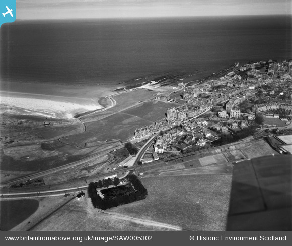
SAW005302 SCOTLAND (1947). The Old Course, The Links, St Andrews. An oblique aerial photograph taken facing north-east.
© Copyright OpenStreetMap contributors and licensed by the OpenStreetMap Foundation. 2026. Cartography is licensed as CC BY-SA.
Nearby Images (9)
Details
| Title | [SAW005302] The Old Course, The Links, St Andrews. An oblique aerial photograph taken facing north-east. |
| Reference | SAW005302 |
| Date | 1947 |
| Link | NRHE Collection item 1268526 |
| Place name | |
| Parish | ST ANDREWS AND ST LEONARDS |
| District | NORTH EAST FIFE |
| Country | SCOTLAND |
| Easting / Northing | 350211, 717048 |
| Longitude / Latitude | -2.8055543094907, 56.343253061782 |
| National Grid Reference | NO502170 |
Pins
Be the first to add a comment to this image!


![[SAW005302] The Old Course, The Links, St Andrews. An oblique aerial photograph taken facing north-east.](http://britainfromabove.org.uk/sites/all/libraries/aerofilms-images/public/100x100/SAW/005/SAW005302.jpg)
![[SAW022549] St Andrews, general view, showing Rusack's Hotel, Pilmour Links and Old Course. An oblique aerial photograph taken facing north. This image has been produced from a crop marked negative.](http://britainfromabove.org.uk/sites/all/libraries/aerofilms-images/public/100x100/SAW/022/SAW022549.jpg)
![[SAR018835] Westcliff Hotel St Andrews and St Leonards, Fife, Scotland. An oblique aerial photograph taken facing South/East. This image was marked by AeroPictorial Ltd for photo editing.](http://britainfromabove.org.uk/sites/all/libraries/aerofilms-images/public/100x100/SAR/018/SAR018835.jpg)
![[SAW022546] St Andrews, general view, showing Rusack's Hotel, Pilmour Links and City Road. An oblique aerial photograph taken facing south.](http://britainfromabove.org.uk/sites/all/libraries/aerofilms-images/public/100x100/SAW/022/SAW022546.jpg)
![[SAW022548] St Andrews, general view, showing Rusack's Hotel, Pilmour Links and Royal and Ancient Golf Club, Golf Place. An oblique aerial photograph taken facing north. This image has been produced from a crop marked negative.](http://britainfromabove.org.uk/sites/all/libraries/aerofilms-images/public/100x100/SAW/022/SAW022548.jpg)
![[SAW022550] St Andrews, general view, showing Rusack's Hotel, Pilmour Links and Royal and Ancient Golf Club, Golf Place. An oblique aerial photograph taken facing east.](http://britainfromabove.org.uk/sites/all/libraries/aerofilms-images/public/100x100/SAW/022/SAW022550.jpg)
![[SAW022547] St Andrews, general view, showing Rusack's Hotel, Pilmour Links and Royal and Ancient Golf Club, Golf Place. An oblique aerial photograph taken facing east. This image has been produced from a crop marked negative.](http://britainfromabove.org.uk/sites/all/libraries/aerofilms-images/public/100x100/SAW/022/SAW022547.jpg)
![[SAW022545] St Andrews, general view, showing Rusack's Hotel, Pilmour Links and North Street. An oblique aerial photograph taken facing south-east. This image has been produced from a crop marked negative.](http://britainfromabove.org.uk/sites/all/libraries/aerofilms-images/public/100x100/SAW/022/SAW022545.jpg)
![[SAW005303] The Old Course, The Links, St Andrews. An oblique aerial photograph taken facing east.](http://britainfromabove.org.uk/sites/all/libraries/aerofilms-images/public/100x100/SAW/005/SAW005303.jpg)