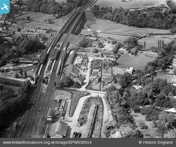
epw038614 ENGLAND (1932). Wilmslow Railway Station, Wilmslow, 1932
© Copyright OpenStreetMap contributors and licensed by the OpenStreetMap Foundation. 2024. Cartography is licensed as CC BY-SA.
Nearby Images (5)
Details
| Title | [EPW038614] Wilmslow Railway Station, Wilmslow, 1932 |
| Reference | EPW038614 |
| Date | June-1932 |
| Link | |
| Place name | WILMSLOW |
| Parish | |
| District | |
| Country | ENGLAND |
| Easting / Northing | 385096, 381105 |
| Longitude / Latitude | -2.2237947913197, 53.326383704478 |
| National Grid Reference | SJ851811 |
Pins
 Roger |
Monday 5th of September 2016 01:26:00 PM | |
 Roger |
Monday 5th of September 2016 01:18:50 PM | |
 Clive Redhead |
Monday 11th of April 2016 07:16:12 PM | |
 Roger |
Sunday 21st of February 2016 06:23:30 PM | |
 IvanSherratt |
Monday 26th of August 2013 09:54:06 PM | |
 mariaud999 |
Thursday 3rd of January 2013 08:22:06 PM | |
 Maurice |
Thursday 20th of December 2012 02:31:23 PM | |
 Maurice |
Thursday 20th of December 2012 02:18:27 PM | |
 Maurice |
Thursday 20th of December 2012 02:09:33 PM | |
 totoro |
Wednesday 19th of December 2012 03:49:42 PM | |
 totoro |
Wednesday 19th of December 2012 03:48:19 PM | |
 totoro |
Wednesday 19th of December 2012 03:44:37 PM |


![[EPW038614] Wilmslow Railway Station, Wilmslow, 1932](http://britainfromabove.org.uk/sites/all/libraries/aerofilms-images/public/100x100/EPW/038/EPW038614.jpg)
![[EPW038616] Wilmslow Railway Station, Wilmslow, 1932](http://britainfromabove.org.uk/sites/all/libraries/aerofilms-images/public/100x100/EPW/038/EPW038616.jpg)
![[EPW038615] Wilmslow Railway Station, Wilmslow, 1932](http://britainfromabove.org.uk/sites/all/libraries/aerofilms-images/public/100x100/EPW/038/EPW038615.jpg)
![[EPW019408] The Railway Station, Wilmslow, 1927](http://britainfromabove.org.uk/sites/all/libraries/aerofilms-images/public/100x100/EPW/019/EPW019408.jpg)
![[EPW019405] The Railway Station and Viaduct, Wilmslow, 1927](http://britainfromabove.org.uk/sites/all/libraries/aerofilms-images/public/100x100/EPW/019/EPW019405.jpg)