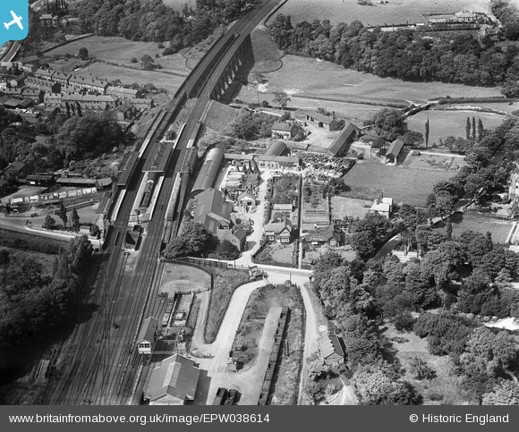
EPW038614 ENGLAND (1932). Wilmslow Railway Station, Wilmslow, 1932

© Copyright OpenStreetMap contributors and licensed by the OpenStreetMap Foundation. 2024. Cartography is licensed as CC BY-SA.

Nearby Images (5)

EPW038614
  0° 0m
EPW038616
  263° 9m
EPW038615
  97° 24m
EPW019408
  250° 75m
EPW019405
  280° 192m

Details

Title [EPW038614] Wilmslow Railway Station, Wilmslow, 1932
Reference EPW038614
Date June-1932
Link
Place name WILMSLOW
Parish
District
Country ENGLAND
Easting / Northing 385096, 381105
Longitude / Latitude -2.2237947913197, 53.326383704478
National Grid Reference SJ851811

Pins

Early bridge spanning the River Bollin, connecting Bollin Hall Farm to Cow Lane. The bridge was positioned slightly to the east of where the Wilmslow North exit roundabout is today located on the Wilmslow by-pass.

Roger
Monday 5th of September 2016 01:26:00 PM
Bollin Hall Farm, remnants of Bollin Hall, a 15th century manor house, which was demolished to make way for the railway early in the 1840's.

Roger
Monday 5th of September 2016 01:18:50 PM
Mill Lade leading to Corn Hill

Clive Redhead
Monday 11th of April 2016 07:16:12 PM
Browns of Wilmslow, established in 1860. Browns was among the UK's oldest companies when it went into administration in 2011.

Roger
Sunday 21st of February 2016 06:23:30 PM
Weighbridge (?)

IvanSherratt
Monday 26th of August 2013 09:54:06 PM
Wilmslow Park Road.

mariaud999
Thursday 3rd of January 2013 08:22:06 PM
Interesting to see this surprisingly large array of advertising hoardings along the station approach at this rather rural looking location. Advertisements include Cadbury's, Colman's, Shinio - metal polish and possibly Bulmer's Cider over a picture of some apples. At least it shows the advertising industry was familiar with the apostrophe in 1932.

Maurice
Thursday 20th of December 2012 02:31:23 PM
This set of buildings and the spaces in between are given over to timber processing. There are heaps of trees in the round, roughly sawn boards and some sawn timber next to the mill at the left of the site. There are also cone shapes stocks of poles and possibly even heaps of firewood. It has the air of local timber yard, taking local wood and providing for local needs, which is supported by the lack of private railway siding.

Maurice
Thursday 20th of December 2012 02:18:27 PM
A LNWR signal box built on a framework over the sidings below. A space saving technique sometime used to install a larger signal box at locations where there was insufficient space on the ground.

Maurice
Thursday 20th of December 2012 02:09:33 PM
River Bollin. The river to the right moves on to Styal Cotton Mill (now National Trust) where it can still drive a large water wheel.

totoro
Wednesday 19th of December 2012 03:49:42 PM
The left hand pair of lines will shortly curve away to Manchester Airport and Styal before heading to rejoin the other pair of lines North of Levenshulme Station at Ardwick Junction. The right hand pair of lines are heading for Cheadle Hulme, Stockport and on to Manchester Piccadilly.

totoro
Wednesday 19th of December 2012 03:48:19 PM
Macclesfield Road

totoro
Wednesday 19th of December 2012 03:44:37 PM