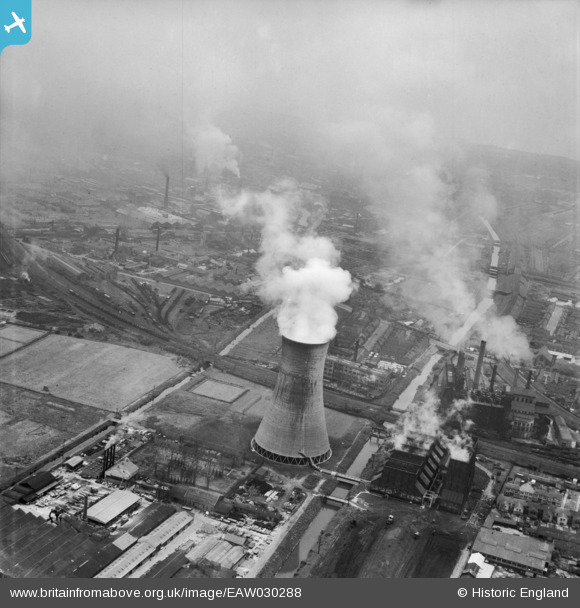
eaw030288 ENGLAND (1950). Sculcoates Power Station, Sculcoates, 1950
© Copyright OpenStreetMap contributors and licensed by the OpenStreetMap Foundation. 2026. Cartography is licensed as CC BY-SA.
Nearby Images (21)
Details
| Title | [EAW030288] Sculcoates Power Station, Sculcoates, 1950 |
| Reference | EAW030288 |
| Date | 13-June-1950 |
| Link | |
| Place name | SCULCOATES |
| Parish | |
| District | |
| Country | ENGLAND |
| Easting / Northing | 509511, 430803 |
| Longitude / Latitude | -0.33857738072923, 53.761835018048 |
| National Grid Reference | TA095308 |
Pins

Philip |
Saturday 25th of October 2014 03:27:47 AM |


![[EAW030288] Sculcoates Power Station, Sculcoates, 1950](http://britainfromabove.org.uk/sites/all/libraries/aerofilms-images/public/100x100/EAW/030/EAW030288.jpg)
![[EPW006337] Sculcoates Cemetery and environs, Sculcoates, 1921](http://britainfromabove.org.uk/sites/all/libraries/aerofilms-images/public/100x100/EPW/006/EPW006337.jpg)
![[EPW042076] Sculcoates Lane, the Greenland Paint & Colour Works and adjacent factories, Sculcoates, 1933](http://britainfromabove.org.uk/sites/all/libraries/aerofilms-images/public/100x100/EPW/042/EPW042076.jpg)
![[EPW042077] Sculcoates Lane, the Greenland Paint & Colour Works and adjacent factories, Sculcoates, 1933](http://britainfromabove.org.uk/sites/all/libraries/aerofilms-images/public/100x100/EPW/042/EPW042077.jpg)
![[EPW042059] The Needlers Ltd Confectionery Works and environs, Sculcoates, from the south-east, 1933](http://britainfromabove.org.uk/sites/all/libraries/aerofilms-images/public/100x100/EPW/042/EPW042059.jpg)
![[EPW006344] Allotments between the Beverley and Barmston Drain and Sculcoates Cemetery, Sculcoates, 1921](http://britainfromabove.org.uk/sites/all/libraries/aerofilms-images/public/100x100/EPW/006/EPW006344.jpg)
![[EPW042058] The Needlers Ltd Confectionery Works and environs, Sculcoates, from the south-east, 1933](http://britainfromabove.org.uk/sites/all/libraries/aerofilms-images/public/100x100/EPW/042/EPW042058.jpg)
![[EPW042060] The Needlers Ltd Confectionery Works, Sculcoates Cemetery and environs, Sculcoates, from the south-east, 1933](http://britainfromabove.org.uk/sites/all/libraries/aerofilms-images/public/100x100/EPW/042/EPW042060.jpg)
![[EAW030289] Sculcoates Power Station Cooling Tower and environs, Sculcoates, 1950](http://britainfromabove.org.uk/sites/all/libraries/aerofilms-images/public/100x100/EAW/030/EAW030289.jpg)
![[EPW042073] Sculcoates Goods Station, the Greenland Paint & Colour Works and the river frontage, Sculcoates, 1933](http://britainfromabove.org.uk/sites/all/libraries/aerofilms-images/public/100x100/EPW/042/EPW042073.jpg)
![[EPW042075] Sculcoates Goods Station and the Greenland Paint & Colour Works, Sculcoates, 1933](http://britainfromabove.org.uk/sites/all/libraries/aerofilms-images/public/100x100/EPW/042/EPW042075.jpg)
![[EPW042078] Sculcoates Lane, the Greenland Paint & Colour Works and adjacent factories, Sculcoates, 1933](http://britainfromabove.org.uk/sites/all/libraries/aerofilms-images/public/100x100/EPW/042/EPW042078.jpg)
![[EPW006338] The Paint and Colour Works, Tannery and other industrial buildings, Sculcoates, 1921](http://britainfromabove.org.uk/sites/all/libraries/aerofilms-images/public/100x100/EPW/006/EPW006338.jpg)
![[EPW006343] Sulcoates Lane Bridge over the Beverley and Barmston Drain, Sculcoates, 1921](http://britainfromabove.org.uk/sites/all/libraries/aerofilms-images/public/100x100/EPW/006/EPW006343.jpg)
![[EPW036498] Sculcoates Cemetery and environs, Sculcoates, 1931](http://britainfromabove.org.uk/sites/all/libraries/aerofilms-images/public/100x100/EPW/036/EPW036498.jpg)
![[EPW036532] Sculcoates Goods Station and environs, Kingston upon Hull, 1931](http://britainfromabove.org.uk/sites/all/libraries/aerofilms-images/public/100x100/EPW/036/EPW036532.jpg)
![[EPW042072] Sculcoates Goods Station, the Greenland Paint & Colour Works and the river frontage, Sculcoates, 1933](http://britainfromabove.org.uk/sites/all/libraries/aerofilms-images/public/100x100/EPW/042/EPW042072.jpg)
![[EPW042055] The Needlers Ltd Confectionery Works and Sculcoates Cemetery, Sculcoates, 1933](http://britainfromabove.org.uk/sites/all/libraries/aerofilms-images/public/100x100/EPW/042/EPW042055.jpg)
![[EPW042057] The Needlers Ltd Confectionery Works, Sculcoates, 1933](http://britainfromabove.org.uk/sites/all/libraries/aerofilms-images/public/100x100/EPW/042/EPW042057.jpg)
![[EPW042074] Sculcoates Goods Station and the Greenland Paint & Colour Works, Sculcoates, 1933](http://britainfromabove.org.uk/sites/all/libraries/aerofilms-images/public/100x100/EPW/042/EPW042074.jpg)
![[EAW030290] Sculcoates Power Station and environs, Sculcoates, from the west, 1950](http://britainfromabove.org.uk/sites/all/libraries/aerofilms-images/public/100x100/EAW/030/EAW030290.jpg)