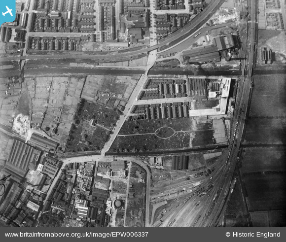
EPW006337 ENGLAND (1921). Sculcoates Cemetery and environs, Sculcoates, 1921
© Copyright OpenStreetMap contributors and licensed by the OpenStreetMap Foundation. 2026. Cartography is licensed as CC BY-SA.
Nearby Images (18)
Details
| Title | [EPW006337] Sculcoates Cemetery and environs, Sculcoates, 1921 |
| Reference | EPW006337 |
| Date | May-1921 |
| Link | |
| Place name | SCULCOATES |
| Parish | |
| District | |
| Country | ENGLAND |
| Easting / Northing | 509408, 430813 |
| Longitude / Latitude | -0.34013575657814, 53.761946512348 |
| National Grid Reference | TA094308 |
Pins

Martin_J |
Tuesday 23rd of June 2020 11:02:29 PM | |

trevorsboy |
Friday 25th of March 2016 07:35:09 PM | |

John Wass |
Sunday 28th of December 2014 03:16:14 PM | |

John Wass |
Monday 18th of August 2014 01:34:53 PM |


![[EPW006337] Sculcoates Cemetery and environs, Sculcoates, 1921](http://britainfromabove.org.uk/sites/all/libraries/aerofilms-images/public/100x100/EPW/006/EPW006337.jpg)
![[EAW030288] Sculcoates Power Station, Sculcoates, 1950](http://britainfromabove.org.uk/sites/all/libraries/aerofilms-images/public/100x100/EAW/030/EAW030288.jpg)
![[EPW042059] The Needlers Ltd Confectionery Works and environs, Sculcoates, from the south-east, 1933](http://britainfromabove.org.uk/sites/all/libraries/aerofilms-images/public/100x100/EPW/042/EPW042059.jpg)
![[EPW006343] Sulcoates Lane Bridge over the Beverley and Barmston Drain, Sculcoates, 1921](http://britainfromabove.org.uk/sites/all/libraries/aerofilms-images/public/100x100/EPW/006/EPW006343.jpg)
![[EPW006344] Allotments between the Beverley and Barmston Drain and Sculcoates Cemetery, Sculcoates, 1921](http://britainfromabove.org.uk/sites/all/libraries/aerofilms-images/public/100x100/EPW/006/EPW006344.jpg)
![[EPW042060] The Needlers Ltd Confectionery Works, Sculcoates Cemetery and environs, Sculcoates, from the south-east, 1933](http://britainfromabove.org.uk/sites/all/libraries/aerofilms-images/public/100x100/EPW/042/EPW042060.jpg)
![[EPW042058] The Needlers Ltd Confectionery Works and environs, Sculcoates, from the south-east, 1933](http://britainfromabove.org.uk/sites/all/libraries/aerofilms-images/public/100x100/EPW/042/EPW042058.jpg)
![[EAW030289] Sculcoates Power Station Cooling Tower and environs, Sculcoates, 1950](http://britainfromabove.org.uk/sites/all/libraries/aerofilms-images/public/100x100/EAW/030/EAW030289.jpg)
![[EPW036498] Sculcoates Cemetery and environs, Sculcoates, 1931](http://britainfromabove.org.uk/sites/all/libraries/aerofilms-images/public/100x100/EPW/036/EPW036498.jpg)
![[EPW042055] The Needlers Ltd Confectionery Works and Sculcoates Cemetery, Sculcoates, 1933](http://britainfromabove.org.uk/sites/all/libraries/aerofilms-images/public/100x100/EPW/042/EPW042055.jpg)
![[EPW042057] The Needlers Ltd Confectionery Works, Sculcoates, 1933](http://britainfromabove.org.uk/sites/all/libraries/aerofilms-images/public/100x100/EPW/042/EPW042057.jpg)
![[EPW006342] The Hull Corporation Electricity Works, Sculcoates, 1921](http://britainfromabove.org.uk/sites/all/libraries/aerofilms-images/public/100x100/EPW/006/EPW006342.jpg)
![[EAW030290] Sculcoates Power Station and environs, Sculcoates, from the west, 1950](http://britainfromabove.org.uk/sites/all/libraries/aerofilms-images/public/100x100/EAW/030/EAW030290.jpg)
![[EPW042076] Sculcoates Lane, the Greenland Paint & Colour Works and adjacent factories, Sculcoates, 1933](http://britainfromabove.org.uk/sites/all/libraries/aerofilms-images/public/100x100/EPW/042/EPW042076.jpg)
![[EPW006347] The Hull Corporation Electricity Works, Sculcoates, 1921](http://britainfromabove.org.uk/sites/all/libraries/aerofilms-images/public/100x100/EPW/006/EPW006347.jpg)
![[EPW006348] The Hull Corporation Electricity Works, Sculcoates, 1921](http://britainfromabove.org.uk/sites/all/libraries/aerofilms-images/public/100x100/EPW/006/EPW006348.jpg)
![[EPW006338] The Paint and Colour Works, Tannery and other industrial buildings, Sculcoates, 1921](http://britainfromabove.org.uk/sites/all/libraries/aerofilms-images/public/100x100/EPW/006/EPW006338.jpg)
![[EPW006339] Sculcoates Junction and the Hull Corporation Electricity Works, Sculcoates, 1921](http://britainfromabove.org.uk/sites/all/libraries/aerofilms-images/public/100x100/EPW/006/EPW006339.jpg)