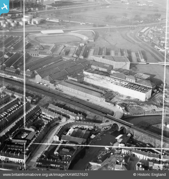
XAW027620 NORTHERN IRELAND (1949). Gallaher Ltd., Factory Premises Bonded Store Works, Belfast, Belfast, Northern Ireland, 1949. Oblique aerial photograph taken facing North. This image was marked by Aerofilms Ltd for photo editing.
© Copyright OpenStreetMap contributors and licensed by the OpenStreetMap Foundation. 2026. Cartography is licensed as CC BY-SA.
Nearby Images (12)
Details
| Title | [XAW027620] Gallaher Ltd., Factory Premises Bonded Store Works, Belfast, Belfast, Northern Ireland, 1949. Oblique aerial photograph taken facing North. This image was marked by Aerofilms Ltd for photo editing. |
| Reference | XAW027620 |
| Date | 2-November-1949 |
| Link | |
| Place name | BELFAST |
| Parish | NORTHERN IRELAND |
| District | |
| Country | NORTHERN IRELAND |
| Easting / Northing | 148857, 529720 |
| Longitude / Latitude | -5.889837, 54.600052 |
| National Grid Reference |
Pins

Richard Craig |
Sunday 14th of November 2021 11:07:43 AM |


![[XAW027620] Gallaher Ltd., Factory Premises Bonded Store Works, Belfast, Belfast, Northern Ireland, 1949. Oblique aerial photograph taken facing North. This image was marked by Aerofilms Ltd for photo editing.](http://britainfromabove.org.uk/sites/all/libraries/aerofilms-images/public/100x100/XAW/027/XAW027620.jpg)
![[XAW027621] Gallaher Ltd., Factory Premises Bonded Store Works, Belfast, Belfast, Northern Ireland, 1949. Oblique aerial photograph taken facing West. This image was marked by Aerofilms Ltd for photo editing.](http://britainfromabove.org.uk/sites/all/libraries/aerofilms-images/public/100x100/XAW/027/XAW027621.jpg)
![[XAW027616] Gallaher Ltd., Factory Premises Bonded Store Works, Belfast, Belfast, Northern Ireland, 1949. Oblique aerial photograph taken facing East. This image was marked by Aerofilms Ltd for photo editing.](http://britainfromabove.org.uk/sites/all/libraries/aerofilms-images/public/100x100/XAW/027/XAW027616.jpg)
![[XAW027615] Gallaher Ltd., Factory Premises Bonded Store Works, Belfast, Belfast, Northern Ireland, 1949. Oblique aerial photograph taken facing North/East. This image was marked by Aerofilms Ltd for photo editing.](http://britainfromabove.org.uk/sites/all/libraries/aerofilms-images/public/100x100/XAW/027/XAW027615.jpg)
![[XAW027623] Gallaher Ltd., Factory Premises Bonded Store Works, Belfast, Belfast, Northern Ireland, 1949. Oblique aerial photograph taken facing North. This image was marked by Aerofilms Ltd for photo editing.](http://britainfromabove.org.uk/sites/all/libraries/aerofilms-images/public/100x100/XAW/027/XAW027623.jpg)
![[XAW027618] Gallaher Ltd., Factory Premises Bonded Store Works, Belfast, Belfast, Northern Ireland, 1949. Oblique aerial photograph taken facing North. This image was marked by Aerofilms Ltd for photo editing.](http://britainfromabove.org.uk/sites/all/libraries/aerofilms-images/public/100x100/XAW/027/XAW027618.jpg)
![[XAW027622] Gallaher Ltd., Factory Premises Bonded Store Works, Belfast, Belfast, Northern Ireland, 1949. Oblique aerial photograph taken facing South/West. This image was marked by Aerofilms Ltd for photo editing.](http://britainfromabove.org.uk/sites/all/libraries/aerofilms-images/public/100x100/XAW/027/XAW027622.jpg)
![[XPW008411] Belfast Irish Distillery Ltd and also Victoria Weaving Co, Belfast, Belfast, Northern Ireland, 1923. Oblique aerial photograph taken facing North/West.](http://britainfromabove.org.uk/sites/all/libraries/aerofilms-images/public/100x100/XPW/008/XPW008411.jpg)
![[XAW027619] Gallaher Ltd., Factory Premises Bonded Store Works, Belfast, Belfast, Northern Ireland, 1949. Oblique aerial photograph taken facing South/East. This image was marked by Aerofilms Ltd for photo editing.](http://britainfromabove.org.uk/sites/all/libraries/aerofilms-images/public/100x100/XAW/027/XAW027619.jpg)
![[XAW027624] Gallaher Ltd., Factory Premises Bonded Store Works, Belfast, Belfast, Northern Ireland, 1949. Oblique aerial photograph taken facing North/West. This image was marked by Aerofilms Ltd for photo editing.](http://britainfromabove.org.uk/sites/all/libraries/aerofilms-images/public/100x100/XAW/027/XAW027624.jpg)
![[XAW027617] Gallaher Ltd., Factory Premises Bonded Store Works, Belfast, Belfast, Northern Ireland, 1949. Oblique aerial photograph taken facing South/East. This image was marked by Aerofilms Ltd for photo editing.](http://britainfromabove.org.uk/sites/all/libraries/aerofilms-images/public/100x100/XAW/027/XAW027617.jpg)
![[XPW015320] Distellery, Belfast, Belfast, Northern Ireland, 1926. Oblique aerial photograph taken facing South.](http://britainfromabove.org.uk/sites/all/libraries/aerofilms-images/public/100x100/XPW/015/XPW015320.jpg)