
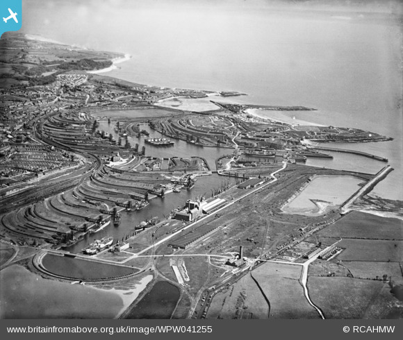
WPW041255 WALES (1933). General view of Barry Docks, oblique aerial view. 5"x4" black and white glass plate negative.
© Copyright OpenStreetMap contributors and licensed by the OpenStreetMap Foundation. 2026. Cartography is licensed as CC BY-SA.
Nearby Images (40)
WAW005933

WAW005934

WAW005935

WAW005936

WAW005937

WAW005938

WAW007742

WAW007743

WAW007745

WAW007746

WAW007747

WAW007748

WAW007749

WAW007750

WAW007814

WAW007814A

WAW007814B

WAW007819

WPW006092

WPW006097

WPW016921

WPW016922

WPW016923

WPW016924

WPW016925

WPW016926

WPW016927

WPW016928

WPW029395

WPW029396

WPW029457

WPW029463

WPW029464

WPW038291

WPW041249

WPW041250

WPW041251

WPW041253

WPW041254

WPW041255

Details
| Title | [WPW041255] General view of Barry Docks, oblique aerial view. 5"x4" black and white glass plate negative. |
| Reference | WPW041255 |
| Date | May-1933 |
| Link | Coflein Archive Item 6369745 |
| Place name | |
| Parish | |
| District | |
| Country | WALES |
| Easting / Northing | 312260, 167140 |
| Longitude / Latitude | -3.2613084674002, 51.396007194558 |
| National Grid Reference | ST123671 |
Pins

sloyne |
Tuesday 23rd of July 2024 09:02:59 PM |
User Comment Contributions
This photo is printed inversely - mirror image. |
phil dawson |
Monday 20th of February 2017 12:24:50 AM |
the photograph wpw041225 needs to be reversed (turned from top to bottom). |
trelissick |
Wednesday 13th of March 2013 01:37:04 AM |
Definitely reversed, as are many photos of Barry Docks. The rectangular number 2 dock is to the east, the half moon timber pond is the easternmost point of the docks. The distinctive double arm dock with central mole is number 1 dock and to the west. This photo is looking along the coast towards the west and the sea should be on the left. |
Capt Vance F Burton |
Monday 8th of October 2012 09:10:56 PM |
I believe that this image has been printed in reverse. The scene is from the east, facing west; No 2 dock is in the foreground and the sea will be on the south or left of the picture. |
handmadeinwood |
Friday 29th of June 2012 11:43:33 AM |