
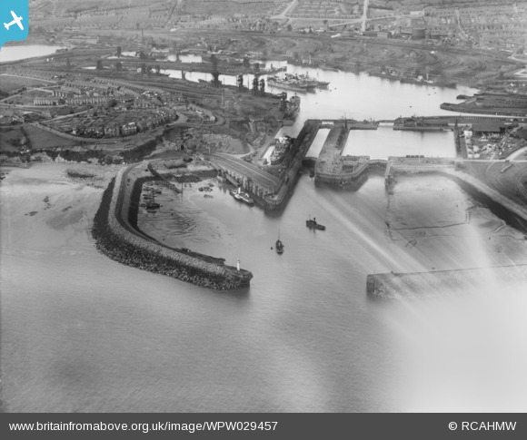
WPW029457 WALES (1929). View of Barry docks, oblique aerial view. 5"x4" black and white glass plate negative.
© Copyright OpenStreetMap contributors and licensed by the OpenStreetMap Foundation. 2026. Cartography is licensed as CC BY-SA.
Nearby Images (40)
WAW005933

WAW005934

WAW005935

WAW005936

WAW005937

WAW005938

WAW007742

WAW007743

WAW007745

WAW007746

WAW007747

WAW007748

WAW007749

WAW007750

WAW007814

WAW007814A

WAW007814B

WAW007819

WPW006092

WPW006097

WPW016921

WPW016922

WPW016923

WPW016924

WPW016925

WPW016926

WPW016927

WPW016928

WPW029395

WPW029396

WPW029457

WPW029463

WPW029464

WPW038291

WPW041249

WPW041250

WPW041251

WPW041253

WPW041254

WPW041255

Details
| Title | [WPW029457] View of Barry docks, oblique aerial view. 5"x4" black and white glass plate negative. |
| Reference | WPW029457 |
| Date | 1929 |
| Link | Coflein Archive Item 6370564 |
| Place name | |
| Parish | |
| District | |
| Country | WALES |
| Easting / Northing | 312260, 167140 |
| Longitude / Latitude | -3.2613084674002, 51.396007194558 |
| National Grid Reference | ST123671 |
Pins

trelissick |
Tuesday 18th of June 2013 09:37:42 PM | |
|
trelissick |
Tuesday 18th of June 2013 09:33:10 PM | |
|
trelissick |
Tuesday 18th of June 2013 09:22:07 PM | |
|
trelissick |
Tuesday 18th of June 2013 09:18:22 PM | |
|
Rob Daniels |
Monday 6th of May 2013 12:00:31 PM | |
|
Rob Daniels |
Monday 6th of May 2013 11:59:28 AM | |
|
Rob Daniels |
Monday 6th of May 2013 11:59:02 AM | |
|
Rob Daniels |
Monday 6th of May 2013 11:58:35 AM | |
|
Rob Daniels |
Monday 6th of May 2013 11:57:47 AM | |
Hi Rob, I see you have named no. three dock for what is really the basin, No. three dock was planned to be situated where the east timber pond and Tom edge is now, but with the drop in coal shipments this never happened, all the best, Trellisick. |
trelissick |
Friday 18th of October 2013 10:12:15 PM |
|
Rob Daniels |
Monday 6th of May 2013 11:57:21 AM | |
The Barry Railway Company operated ships until April 1910 when the 4 vessels passed to Bristol Channel Passenger Boats Ltd, then in December 1911 to P & A Campbell, whose white funnel this boat bears. However I don't think this is one of the ex Barry Railway ships, as 2 of the 4 were no longer in the fleet by the time this photo was taken and of these "Devonia" had 2 funnels and "Barry" had a full length promenade deck. On Balance I think this is "Ravenswood" of 1891 which spent most of her career on the Cardiff to Weston ferry run. |
mannidaze |
Thursday 6th of November 2014 03:49:54 PM |
|
Rob Daniels |
Monday 6th of May 2013 11:56:19 AM | |
|
Rob Daniels |
Monday 6th of May 2013 11:55:17 AM | |
|
Rob Daniels |
Monday 6th of May 2013 11:54:52 AM | |
|
Rob Daniels |
Monday 6th of May 2013 11:54:15 AM | |
|
Rob Daniels |
Monday 6th of May 2013 11:53:52 AM |
User Comment Contributions
P & A Campbell paddle steamer "Ravenswood" alongside the pontoon . |
Bobbanker |
Tuesday 26th of June 2012 02:17:29 PM |