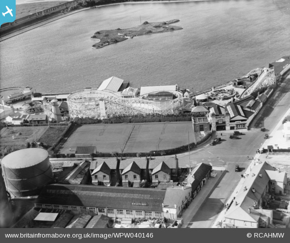
WPW040146 WALES (1932). View of Rhyl showing the Marine Lake and funfair, oblique aerial view. 5"x4" black and white glass plate negative.
© Copyright OpenStreetMap contributors and licensed by the OpenStreetMap Foundation. 2026. Cartography is licensed as CC BY-SA.
Nearby Images (48)
Details
| Title | [WPW040146] View of Rhyl showing the Marine Lake and funfair, oblique aerial view. 5"x4" black and white glass plate negative. |
| Reference | WPW040146 |
| Date | 1932 |
| Link | Coflein Archive Item 6369717 |
| Place name | |
| Parish | |
| District | |
| Country | WALES |
| Easting / Northing | 300865, 381430 |
| Longitude / Latitude | -3.4884193458625, 53.320230803048 |
| National Grid Reference | SJ009814 |
Pins
Be the first to add a comment to this image!
User Comment Contributions
This was the original funfair site - it later moved to the other side of Wellington Road to a seafront site |

Pete65 |
Thursday 20th of November 2014 01:52:51 AM |


![[WAW023323] View of Rhyl showing pier](http://britainfromabove.org.uk/sites/all/libraries/aerofilms-images/public/100x100/WAW/023/WAW023323.jpg)
![[WAW023324] View of Rhyl showing pier](http://britainfromabove.org.uk/sites/all/libraries/aerofilms-images/public/100x100/WAW/023/WAW023324.jpg)
![[WAW023325] View of Rhyl showing funfair and boating lake](http://britainfromabove.org.uk/sites/all/libraries/aerofilms-images/public/100x100/WAW/023/WAW023325.jpg)
![[WAW023326] View of Rhyl showing pier](http://britainfromabove.org.uk/sites/all/libraries/aerofilms-images/public/100x100/WAW/023/WAW023326.jpg)
![[WAW024734] Distant view of Rhyl](http://britainfromabove.org.uk/sites/all/libraries/aerofilms-images/public/100x100/WAW/024/WAW024734.jpg)
![[WAW024735] Distant view of Rhyl](http://britainfromabove.org.uk/sites/all/libraries/aerofilms-images/public/100x100/WAW/024/WAW024735.jpg)
![[WAW024736] Distant view of Rhyl](http://britainfromabove.org.uk/sites/all/libraries/aerofilms-images/public/100x100/WAW/024/WAW024736.jpg)
![[WAW024737] Distant view of Rhyl](http://britainfromabove.org.uk/sites/all/libraries/aerofilms-images/public/100x100/WAW/024/WAW024737.jpg)
![[WAW024738] View of Rhyl showing promenade gardens, swimming pool and pier](http://britainfromabove.org.uk/sites/all/libraries/aerofilms-images/public/100x100/WAW/024/WAW024738.jpg)
![[WAW024739] View of Rhyl showing promenade gardens, swimming pool and pier](http://britainfromabove.org.uk/sites/all/libraries/aerofilms-images/public/100x100/WAW/024/WAW024739.jpg)
![[WPW002012] View of Rhyl showing the new pavillion and bandstand complex, oblique aerial view. 5"x4" black and white glass plate negative.](http://britainfromabove.org.uk/sites/all/libraries/aerofilms-images/public/100x100/WPW/002/WPW002012.jpg)
![[WPW002013] View of Rhyl showing the new pavillion and bandstand complex, oblique aerial view. 5"x4" black and white glass plate negative.](http://britainfromabove.org.uk/sites/all/libraries/aerofilms-images/public/100x100/WPW/002/WPW002013.jpg)
![[WPW002014] View of Rhyl showing railway station and pier, oblique aerial view. 5"x4" black and white glass plate negative.](http://britainfromabove.org.uk/sites/all/libraries/aerofilms-images/public/100x100/WPW/002/WPW002014.jpg)
![[WPW002015] View of Rhyl showing St Thomas's church, oblique aerial view. 5"x4" black and white glass plate negative.](http://britainfromabove.org.uk/sites/all/libraries/aerofilms-images/public/100x100/WPW/002/WPW002015.jpg)
![[WPW002016] View of Rhyl showing seafront and the Amphitheatre, oblique aerial view. 5"x4" black and white glass plate negative.](http://britainfromabove.org.uk/sites/all/libraries/aerofilms-images/public/100x100/WPW/002/WPW002016.jpg)
![[WPW002018] View of Rhyl showing the new pavillion and bandstand complex, oblique aerial view. 5"x4" black and white glass plate negative.](http://britainfromabove.org.uk/sites/all/libraries/aerofilms-images/public/100x100/WPW/002/WPW002018.jpg)
![[WPW002019] View of Rhyl showing the Marine Lake and Pleasure Park, oblique aerial view. 5"x4" black and white glass plate negative.](http://britainfromabove.org.uk/sites/all/libraries/aerofilms-images/public/100x100/WPW/002/WPW002019.jpg)
![[WPW002020] General view of Rhyl, oblique aerial view. 5"x4" black and white glass plate negative.](http://britainfromabove.org.uk/sites/all/libraries/aerofilms-images/public/100x100/WPW/002/WPW002020.jpg)
![[WPW002021] View of Rhyl showing the Marine Lake and Pleasure Park, oblique aerial view. 5"x4" black and white glass plate negative.](http://britainfromabove.org.uk/sites/all/libraries/aerofilms-images/public/100x100/WPW/002/WPW002021.jpg)
![[WPW002022] View of Rhyl showing the new pavillion and bandstand complex, oblique aerial view. 5"x4" black and white glass plate negative.](http://britainfromabove.org.uk/sites/all/libraries/aerofilms-images/public/100x100/WPW/002/WPW002022.jpg)
![[WPW002023] View of Rhyl showing the new pavillion and bandstand complex, oblique aerial view. 5"x4" black and white glass plate negative.](http://britainfromabove.org.uk/sites/all/libraries/aerofilms-images/public/100x100/WPW/002/WPW002023.jpg)
![[WPW002024] View of Rhyl showing the new pavillion and bandstand complex, oblique aerial view. 5"x4" black and white glass plate negative.](http://britainfromabove.org.uk/sites/all/libraries/aerofilms-images/public/100x100/WPW/002/WPW002024.jpg)
![[WPW002025] View of Rhyl showing the Marine Lake and Pleasure Park, oblique aerial view. 5"x4" black and white glass plate negative.](http://britainfromabove.org.uk/sites/all/libraries/aerofilms-images/public/100x100/WPW/002/WPW002025.jpg)
![[WPW002026] View of Rhyl showing the lifeboat station, oblique aerial view. 5"x4" black and white glass plate negative.](http://britainfromabove.org.uk/sites/all/libraries/aerofilms-images/public/100x100/WPW/002/WPW002026.jpg)
![[WPW002027] View of Rhyl showing town, oblique aerial view. 5"x4" black and white glass plate negative.](http://britainfromabove.org.uk/sites/all/libraries/aerofilms-images/public/100x100/WPW/002/WPW002027.jpg)
![[WPW002028] View of Rhyl showing town, oblique aerial view. 5"x4" black and white glass plate negative.](http://britainfromabove.org.uk/sites/all/libraries/aerofilms-images/public/100x100/WPW/002/WPW002028.jpg)
![[WPW002029] View of Rhyl showing the new pavillion and bandstand, oblique aerial view. 5"x4" black and white glass plate negative.](http://britainfromabove.org.uk/sites/all/libraries/aerofilms-images/public/100x100/WPW/002/WPW002029.jpg)
![[WPW002031] View of Rhyl showing the new pavillion and bandstand, oblique aerial view. 5"x4" black and white glass plate negative.](http://britainfromabove.org.uk/sites/all/libraries/aerofilms-images/public/100x100/WPW/002/WPW002031.jpg)
![[WPW002032] View of Rhyl showing town, oblique aerial view. 5"x4" black and white glass plate negative.](http://britainfromabove.org.uk/sites/all/libraries/aerofilms-images/public/100x100/WPW/002/WPW002032.jpg)
![[WPW002034] View of Rhyl showing town, oblique aerial view. 5"x4" black and white glass plate negative.](http://britainfromabove.org.uk/sites/all/libraries/aerofilms-images/public/100x100/WPW/002/WPW002034.jpg)
![[WPW040144] View of Rhyl showing promenade, pier, bandstand, pleasure gardens and open air swimming pool, oblique aerial view. 5"x4" black and white glass plate negative.](http://britainfromabove.org.uk/sites/all/libraries/aerofilms-images/public/100x100/WPW/040/WPW040144.jpg)
![[WPW040145] View of Rhyl showing promenade, pier, bandstand, pleasure gardens and open air swimming pool, oblique aerial view. 5"x4" black and white glass plate negative.](http://britainfromabove.org.uk/sites/all/libraries/aerofilms-images/public/100x100/WPW/040/WPW040145.jpg)
![[WPW040146] View of Rhyl showing the Marine Lake and funfair, oblique aerial view. 5"x4" black and white glass plate negative.](http://britainfromabove.org.uk/sites/all/libraries/aerofilms-images/public/100x100/WPW/040/WPW040146.jpg)
![[WPW040147] General view of Rhyl, oblique aerial view. 5"x4" black and white glass plate negative.](http://britainfromabove.org.uk/sites/all/libraries/aerofilms-images/public/100x100/WPW/040/WPW040147.jpg)
![[WPW040148] General view of Rhyl, oblique aerial view. 5"x4" black and white glass plate negative.](http://britainfromabove.org.uk/sites/all/libraries/aerofilms-images/public/100x100/WPW/040/WPW040148.jpg)
![[WPW040149] General view of Rhyl, oblique aerial view. 5"x4" black and white glass plate negative.](http://britainfromabove.org.uk/sites/all/libraries/aerofilms-images/public/100x100/WPW/040/WPW040149.jpg)
![[WPW040150] View of Rhyl showing the Marine Lake and funfair, oblique aerial view. 5"x4" black and white glass plate negative.](http://britainfromabove.org.uk/sites/all/libraries/aerofilms-images/public/100x100/WPW/040/WPW040150.jpg)
![[WPW045181] View of Rhyl, oblique aerial view. 5"x4" black and white glass plate negative.](http://britainfromabove.org.uk/sites/all/libraries/aerofilms-images/public/100x100/WPW/045/WPW045181.jpg)
![[WPW045182] View of Rhyl, oblique aerial view. 5"x4" black and white glass plate negative.](http://britainfromabove.org.uk/sites/all/libraries/aerofilms-images/public/100x100/WPW/045/WPW045182.jpg)
![[WPW045183] View of Rhyl, oblique aerial view. 5"x4" black and white glass plate negative.](http://britainfromabove.org.uk/sites/all/libraries/aerofilms-images/public/100x100/WPW/045/WPW045183.jpg)
![[WPW045184] View of Rhyl, oblique aerial view. 5"x4" black and white glass plate negative.](http://britainfromabove.org.uk/sites/all/libraries/aerofilms-images/public/100x100/WPW/045/WPW045184.jpg)
![[WPW045185] View of Rhyl, oblique aerial view. 5"x4" black and white glass plate negative.](http://britainfromabove.org.uk/sites/all/libraries/aerofilms-images/public/100x100/WPW/045/WPW045185.jpg)
![[WPW051608] View of Rhyl showing pier and swimming pools, oblique aerial view. 5"x4" black and white glass plate negative.](http://britainfromabove.org.uk/sites/all/libraries/aerofilms-images/public/100x100/WPW/051/WPW051608.jpg)
![[WPW051609] View of Rhyl showing pier, oblique aerial view. 5"x4" black and white glass plate negative.](http://britainfromabove.org.uk/sites/all/libraries/aerofilms-images/public/100x100/WPW/051/WPW051609.jpg)
![[WPW055740] View of the Kinmel Bay area of Rhyl showing holiday camp, oblique aerial view. 5"x4" black and white glass plate negative.](http://britainfromabove.org.uk/sites/all/libraries/aerofilms-images/public/100x100/WPW/055/WPW055740.jpg)
![[WPW055741] View of Rhyl, oblique aerial view. 5"x4" black and white glass plate negative.](http://britainfromabove.org.uk/sites/all/libraries/aerofilms-images/public/100x100/WPW/055/WPW055741.jpg)
![[WPW055742] View of Rhyl showing recreation grounds on seafront, oblique aerial view. 5"x4" black and white glass plate negative.](http://britainfromabove.org.uk/sites/all/libraries/aerofilms-images/public/100x100/WPW/055/WPW055742.jpg)
![[WPW055743] General view of Rhyl, oblique aerial view. 5"x4" black and white glass plate negative.](http://britainfromabove.org.uk/sites/all/libraries/aerofilms-images/public/100x100/WPW/055/WPW055743.jpg)