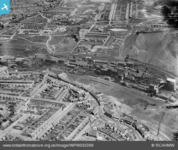
WPW032398 WALES (1930). View of Aberbargoed and Bargoed with Bargoed Colliery in the centre, oblique aerial view. 5"x4" black and white glass plate negative.
© Copyright OpenStreetMap contributors and licensed by the OpenStreetMap Foundation. 2026. Cartography is licensed as CC BY-SA.
Nearby Images (5)
Details
| Title | [WPW032398] View of Aberbargoed and Bargoed with Bargoed Colliery in the centre, oblique aerial view. 5"x4" black and white glass plate negative. |
| Reference | WPW032398 |
| Date | 1930 |
| Link | Coflein Archive Item 6378009 |
| Place name | |
| Parish | |
| District | |
| Country | WALES |
| Easting / Northing | 315300, 199800 |
| Longitude / Latitude | -3.2254807356414, 51.690095615532 |
| National Grid Reference | ST153998 |
Pins

Bill Smith |
Tuesday 11th of December 2012 04:19:35 PM | |

Bill Smith |
Tuesday 11th of December 2012 04:17:55 PM | |

Bill Smith |
Tuesday 11th of December 2012 04:16:09 PM | |

Bill Smith |
Tuesday 11th of December 2012 04:15:32 PM | |

Bill Smith |
Tuesday 11th of December 2012 04:14:52 PM | |

Class31 |
Tuesday 17th of July 2012 12:24:49 PM | |

Class31 |
Tuesday 17th of July 2012 12:23:50 PM | |

Class31 |
Tuesday 17th of July 2012 12:20:37 PM | |

Class31 |
Tuesday 17th of July 2012 12:20:16 PM | |

Class31 |
Tuesday 17th of July 2012 12:19:19 PM | |

Class31 |
Tuesday 17th of July 2012 12:18:56 PM | |

Class31 |
Tuesday 17th of July 2012 12:17:18 PM | |

Class31 |
Tuesday 17th of July 2012 12:17:00 PM |
User Comment Contributions
This is an aerial photograph of Bargoed colliery (centre). Bargoed town on the bottom,AberBargoed on the top of the Photo. |

Barnett |
Thursday 14th of February 2013 11:24:51 AM |
This photograph can be identified as looking East from over Bargoed towards Aberbargoed across the Rhymney Valley. In the foreground we see Bargoed with it's unique road layout> In the centre is Bargoed Colliery and in the distance Aberbargoed. Map ReferenceSJ 28226 46995. |

Class31 |
Tuesday 17th of July 2012 12:30:52 PM |


![[WPW032398] View of Aberbargoed and Bargoed with Bargoed Colliery in the centre, oblique aerial view. 5"x4" black and white glass plate negative.](http://britainfromabove.org.uk/sites/all/libraries/aerofilms-images/public/100x100/WPW/032/WPW032398.jpg)
![[WPW032399] View of Aberbargoed and Bargoed looking from west, oblique aerial view. 5"x4" black and white glass plate negative.](http://britainfromabove.org.uk/sites/all/libraries/aerofilms-images/public/100x100/WPW/032/WPW032399.jpg)
![[WPW032432] General view of Aberbargoed, oblique aerial view. 5"x4" black and white glass plate negative.](http://britainfromabove.org.uk/sites/all/libraries/aerofilms-images/public/100x100/WPW/032/WPW032432.jpg)
![[WPW032433] View of new housing at Aberbargoed, oblique aerial view. 5"x4" black and white glass plate negative.](http://britainfromabove.org.uk/sites/all/libraries/aerofilms-images/public/100x100/WPW/032/WPW032433.jpg)
![[WPW032434] View of new housing at Aberbargoed, oblique aerial view. 5"x4" black and white glass plate negative.](http://britainfromabove.org.uk/sites/all/libraries/aerofilms-images/public/100x100/WPW/032/WPW032434.jpg)