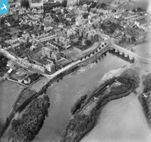
WPW029904 WALES (1929). General view of Monmouth, oblique aerial view. 5"x4" black and white glass plate negative.
© Copyright OpenStreetMap contributors and licensed by the OpenStreetMap Foundation. 2026. Cartography is licensed as CC BY-SA.
Nearby Images (48)
Details
| Title | [WPW029904] General view of Monmouth, oblique aerial view. 5"x4" black and white glass plate negative. |
| Reference | WPW029904 |
| Date | 1929 |
| Link | Coflein Archive Item 6370704 |
| Place name | |
| Parish | |
| District | |
| Country | WALES |
| Easting / Northing | 350740, 212819 |
| Longitude / Latitude | -2.7146209238032, 51.811384535538 |
| National Grid Reference | SO507128 |
Pins
User Comment Contributions

owain |
Thursday 28th of June 2012 11:43:55 AM |


![[WAW007084] View west of Monmouth looking North West from Llangynidr to Brecon on River Usk](http://britainfromabove.org.uk/sites/all/libraries/aerofilms-images/public/100x100/WAW/007/WAW007084.jpg)
![[WAW007085] View west of Monmouth looking North West from Llangynidr to Brecon on River Usk](http://britainfromabove.org.uk/sites/all/libraries/aerofilms-images/public/100x100/WAW/007/WAW007085.jpg)
![[WAW007086] View west of Monmouth looking North West from Llangynidr to Brecon on River Usk](http://britainfromabove.org.uk/sites/all/libraries/aerofilms-images/public/100x100/WAW/007/WAW007086.jpg)
![[WAW007087] View west of Monmouth looking North West from Llangynidr to Brecon on River Usk](http://britainfromabove.org.uk/sites/all/libraries/aerofilms-images/public/100x100/WAW/007/WAW007087.jpg)
![[WAW007088] Distant view of Monmouth](http://britainfromabove.org.uk/sites/all/libraries/aerofilms-images/public/100x100/WAW/007/WAW007088.jpg)
![[WAW007089] Distant view of Monmouth](http://britainfromabove.org.uk/sites/all/libraries/aerofilms-images/public/100x100/WAW/007/WAW007089.jpg)
![[WAW016142] General view of Monmouth](http://britainfromabove.org.uk/sites/all/libraries/aerofilms-images/public/100x100/WAW/016/WAW016142.jpg)
![[WAW016143] General view of Monmouth](http://britainfromabove.org.uk/sites/all/libraries/aerofilms-images/public/100x100/WAW/016/WAW016143.jpg)
![[WPW006051] General view of Monmouth, oblique aerial view. 5"x4" black and white glass plate negative.](http://britainfromabove.org.uk/sites/all/libraries/aerofilms-images/public/100x100/WPW/006/WPW006051.jpg)
![[WPW006052] View of Monmouth showing cattle market and fairground with fair in progress, oblique aerial view. 5"x4" black and white glass plate negative.](http://britainfromabove.org.uk/sites/all/libraries/aerofilms-images/public/100x100/WPW/006/WPW006052.jpg)
![[WPW006053] General view of Monmouth, oblique aerial view. 5"x4" black and white glass plate negative.](http://britainfromabove.org.uk/sites/all/libraries/aerofilms-images/public/100x100/WPW/006/WPW006053.jpg)
![[WPW006054] General view of Monmouth, oblique aerial view. 5"x4" black and white glass plate negative.](http://britainfromabove.org.uk/sites/all/libraries/aerofilms-images/public/100x100/WPW/006/WPW006054.jpg)
![[WPW006055] View of landscape near Monmouth, oblique aerial view. 5"x4" black and white glass plate negative.](http://britainfromabove.org.uk/sites/all/libraries/aerofilms-images/public/100x100/WPW/006/WPW006055.jpg)
![[WPW006056] View of landscape near Monmouth, oblique aerial view. 5"x4" black and white glass plate negative.](http://britainfromabove.org.uk/sites/all/libraries/aerofilms-images/public/100x100/WPW/006/WPW006056.jpg)
![[WPW006057] View of landscape near Monmouth, oblique aerial view. 5"x4" black and white glass plate negative.](http://britainfromabove.org.uk/sites/all/libraries/aerofilms-images/public/100x100/WPW/006/WPW006057.jpg)
![[WPW006058] View of landscape near Monmouth, oblique aerial view. 5"x4" black and white glass plate negative.](http://britainfromabove.org.uk/sites/all/libraries/aerofilms-images/public/100x100/WPW/006/WPW006058.jpg)
![[WPW006059] View of landscape near Monmouth, oblique aerial view. 5"x4" black and white glass plate negative.](http://britainfromabove.org.uk/sites/all/libraries/aerofilms-images/public/100x100/WPW/006/WPW006059.jpg)
![[WPW029894] General view of Monmouth, oblique aerial view. 5"x4" black and white glass plate negative.](http://britainfromabove.org.uk/sites/all/libraries/aerofilms-images/public/100x100/WPW/029/WPW029894.jpg)
![[WPW029895] General view of Monmouth, oblique aerial view. 5"x4" black and white glass plate negative.](http://britainfromabove.org.uk/sites/all/libraries/aerofilms-images/public/100x100/WPW/029/WPW029895.jpg)
![[WPW029896] General view of Monmouth, oblique aerial view. 5"x4" black and white glass plate negative.](http://britainfromabove.org.uk/sites/all/libraries/aerofilms-images/public/100x100/WPW/029/WPW029896.jpg)
![[WPW029902] General view of Monmouth, oblique aerial view. 5"x4" black and white glass plate negative.](http://britainfromabove.org.uk/sites/all/libraries/aerofilms-images/public/100x100/WPW/029/WPW029902.jpg)
![[WPW029903] General view of Monmouth, oblique aerial view. 5"x4" black and white glass plate negative.](http://britainfromabove.org.uk/sites/all/libraries/aerofilms-images/public/100x100/WPW/029/WPW029903.jpg)
![[WPW029904] General view of Monmouth, oblique aerial view. 5"x4" black and white glass plate negative.](http://britainfromabove.org.uk/sites/all/libraries/aerofilms-images/public/100x100/WPW/029/WPW029904.jpg)
![[WPW029908] View of Wye Bridge, Monmouth, oblique aerial view. 5"x4" black and white glass plate negative.](http://britainfromabove.org.uk/sites/all/libraries/aerofilms-images/public/100x100/WPW/029/WPW029908.jpg)
![[WPW039974] General view of Monmouth, oblique aerial view. 5"x4" black and white glass plate negative.](http://britainfromabove.org.uk/sites/all/libraries/aerofilms-images/public/100x100/WPW/039/WPW039974.jpg)
![[WPW039975] General view of Monmouth, oblique aerial view. 5"x4" black and white glass plate negative.](http://britainfromabove.org.uk/sites/all/libraries/aerofilms-images/public/100x100/WPW/039/WPW039975.jpg)
![[WPW039976] General view of Monmouth, oblique aerial view. 5"x4" black and white glass plate negative.](http://britainfromabove.org.uk/sites/all/libraries/aerofilms-images/public/100x100/WPW/039/WPW039976.jpg)
![[WPW039977] General view of Monmouth, oblique aerial view. 5"x4" black and white glass plate negative.](http://britainfromabove.org.uk/sites/all/libraries/aerofilms-images/public/100x100/WPW/039/WPW039977.jpg)
![[WPW048170] View of Monmouth, oblique aerial view. 5"x4" black and white glass plate negative.](http://britainfromabove.org.uk/sites/all/libraries/aerofilms-images/public/100x100/WPW/048/WPW048170.jpg)
![[WPW048171] View of Monmouth, oblique aerial view. 5"x4" black and white glass plate negative.](http://britainfromabove.org.uk/sites/all/libraries/aerofilms-images/public/100x100/WPW/048/WPW048171.jpg)
![[WPW048172] View of Monmouth showing school, oblique aerial view. 5"x4" black and white glass plate negative.](http://britainfromabove.org.uk/sites/all/libraries/aerofilms-images/public/100x100/WPW/048/WPW048172.jpg)
![[WPW048173] View of Monmouth showing school, oblique aerial view. 5"x4" black and white glass plate negative.](http://britainfromabove.org.uk/sites/all/libraries/aerofilms-images/public/100x100/WPW/048/WPW048173.jpg)
![[WPW048174] View of Monmouth showing school, oblique aerial view. 5"x4" black and white glass plate negative.](http://britainfromabove.org.uk/sites/all/libraries/aerofilms-images/public/100x100/WPW/048/WPW048174.jpg)
![[WPW048175] View of Monmouth showing school, oblique aerial view. 5"x4" black and white glass plate negative.](http://britainfromabove.org.uk/sites/all/libraries/aerofilms-images/public/100x100/WPW/048/WPW048175.jpg)
![[WPW048176] View of Monmouth showing school, oblique aerial view. 5"x4" black and white glass plate negative.](http://britainfromabove.org.uk/sites/all/libraries/aerofilms-images/public/100x100/WPW/048/WPW048176.jpg)
![[WPW048177] View of Monmouth showing school, oblique aerial view. 5"x4" black and white glass plate negative.](http://britainfromabove.org.uk/sites/all/libraries/aerofilms-images/public/100x100/WPW/048/WPW048177.jpg)
![[WPW048178] View of Monmouth showing school, oblique aerial view. 5"x4" black and white glass plate negative.](http://britainfromabove.org.uk/sites/all/libraries/aerofilms-images/public/100x100/WPW/048/WPW048178.jpg)
![[WPW048179] View of Monmouth showing school and viaduct, oblique aerial view. 5"x4" black and white glass plate negative.](http://britainfromabove.org.uk/sites/all/libraries/aerofilms-images/public/100x100/WPW/048/WPW048179.jpg)
![[WPW048180] View of Monmouth showing school and viaduct, oblique aerial view. 5"x4" black and white glass plate negative.](http://britainfromabove.org.uk/sites/all/libraries/aerofilms-images/public/100x100/WPW/048/WPW048180.jpg)
![[WPW048181] View of Monmouth showing school and viaduct, oblique aerial view. 5"x4" black and white glass plate negative.](http://britainfromabove.org.uk/sites/all/libraries/aerofilms-images/public/100x100/WPW/048/WPW048181.jpg)
![[WPW058582] General view of Monmouth, oblique aerial view. 5"x4" black and white glass plate negative.](http://britainfromabove.org.uk/sites/all/libraries/aerofilms-images/public/100x100/WPW/058/WPW058582.jpg)
![[WPW058583] General view of Monmouth, oblique aerial view. 5"x4" black and white glass plate negative.](http://britainfromabove.org.uk/sites/all/libraries/aerofilms-images/public/100x100/WPW/058/WPW058583.jpg)
![[WPW058584] General view of Monmouth, oblique aerial view. 5"x4" black and white glass plate negative.](http://britainfromabove.org.uk/sites/all/libraries/aerofilms-images/public/100x100/WPW/058/WPW058584.jpg)
![[WPW058585] General view of Monmouth, oblique aerial view. 5"x4" black and white glass plate negative.](http://britainfromabove.org.uk/sites/all/libraries/aerofilms-images/public/100x100/WPW/058/WPW058585.jpg)
![[WPW058586] General view of Monmouth, oblique aerial view. 5"x4" black and white glass plate negative.](http://britainfromabove.org.uk/sites/all/libraries/aerofilms-images/public/100x100/WPW/058/WPW058586.jpg)
![[WPW058587] View of Monmouth showing Monnow Bridge, Monnow Street and Cattle Market, oblique aerial view. 5"x4" black and white glass plate negative.](http://britainfromabove.org.uk/sites/all/libraries/aerofilms-images/public/100x100/WPW/058/WPW058587.jpg)
![[WPW058588] View of Monmouth showing Monnow bridge and cattle market. Oblique aerial photograph, 5"x4" BW glass plate.](http://britainfromabove.org.uk/sites/all/libraries/aerofilms-images/public/100x100/WPW/058/WPW058588.jpg)
![[WPW029905] View of Monmouth showing school, oblique aerial view. 5"x4" black and white glass plate negative.](http://britainfromabove.org.uk/sites/all/libraries/aerofilms-images/public/100x100/WPW/029/WPW029905.jpg)

