
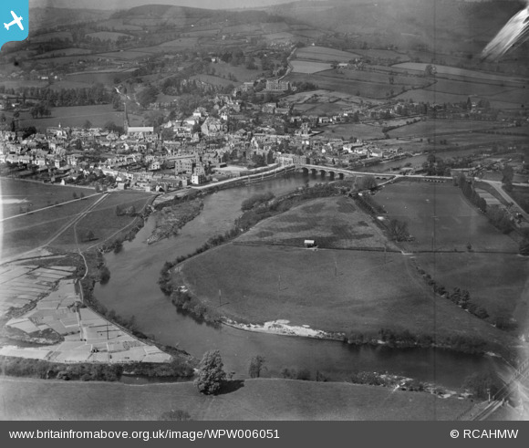
WPW006051 WALES (1921). General view of Monmouth, oblique aerial view. 5"x4" black and white glass plate negative.
© Copyright OpenStreetMap contributors and licensed by the OpenStreetMap Foundation. 2026. Cartography is licensed as CC BY-SA.
Nearby Images (48)
WAW007084

WAW007085

WAW007086

WAW007087

WAW007088

WAW007089

WAW016142

WAW016143

WPW006051

WPW006052

WPW006053

WPW006054

WPW006055

WPW006056

WPW006057

WPW006058

WPW006059

WPW029894

WPW029895

WPW029896

WPW029902

WPW029903

WPW029904

WPW029908

WPW039974

WPW039975

WPW039976

WPW039977

WPW048170

WPW048171

WPW048172

WPW048173

WPW048174

WPW048175

WPW048176

WPW048177

WPW048178

WPW048179

WPW048180

WPW048181

WPW058582

WPW058583

WPW058584

WPW058585

WPW058586

WPW058587

WPW058588

WPW029905

Details
| Title | [WPW006051] General view of Monmouth, oblique aerial view. 5"x4" black and white glass plate negative. |
| Reference | WPW006051 |
| Date | 1921 |
| Link | Coflein Archive Item 6370296 |
| Place name | |
| Parish | |
| District | |
| Country | WALES |
| Easting / Northing | 350740, 212819 |
| Longitude / Latitude | -2.7146209238032, 51.811384535538 |
| National Grid Reference | SO507128 |
Pins

Class31 |
Friday 3rd of June 2016 07:18:31 PM |

User Comment Contributions
The Bridge on the River Wye. |

Brian Wilkinson |
Monday 11th of June 2012 01:42:27 PM |