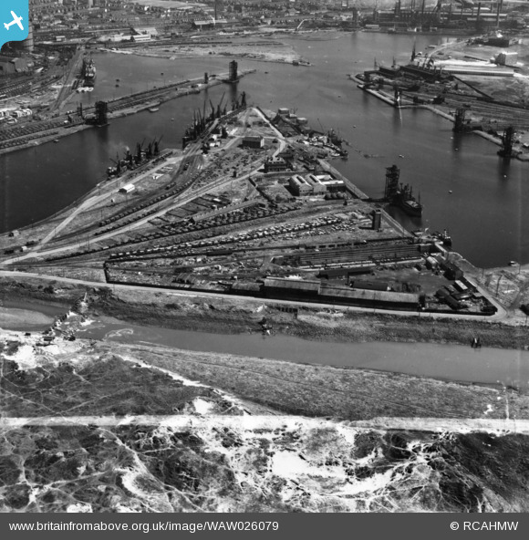
WAW026079 WALES (1949). View of dry, new and old docks and entrance channel, Port Talbot. Oblique aerial photograph, 5½" cut roll film.
© Copyright OpenStreetMap contributors and licensed by the OpenStreetMap Foundation. 2026. Cartography is licensed as CC BY-SA.
Nearby Images (37)
Details
| Title | [WAW026079] View of dry, new and old docks and entrance channel, Port Talbot. Oblique aerial photograph, 5½" cut roll film. |
| Reference | WAW026079 |
| Date | 12-August-1949 |
| Link | Coflein Archive Item 6423525 |
| Place name | |
| Parish | |
| District | |
| Country | WALES |
| Easting / Northing | 276000, 189000 |
| Longitude / Latitude | -3.7900131148748, 51.585721062159 |
| National Grid Reference | SS760890 |
Pins
Be the first to add a comment to this image!


![[WAW005817] General view of Port Talbot docks](http://britainfromabove.org.uk/sites/all/libraries/aerofilms-images/public/100x100/WAW/005/WAW005817.jpg)
![[WAW005819] General view of Port Talbot showing docks](http://britainfromabove.org.uk/sites/all/libraries/aerofilms-images/public/100x100/WAW/005/WAW005819.jpg)
![[WAW005820] General view of Port Talbot docks](http://britainfromabove.org.uk/sites/all/libraries/aerofilms-images/public/100x100/WAW/005/WAW005820.jpg)
![[WAW005821] General view of Port Talbot showing docks](http://britainfromabove.org.uk/sites/all/libraries/aerofilms-images/public/100x100/WAW/005/WAW005821.jpg)
![[WAW005822] General view of Port Talbot docks](http://britainfromabove.org.uk/sites/all/libraries/aerofilms-images/public/100x100/WAW/005/WAW005822.jpg)
![[WAW005823] General view of Port Talbot showing docks](http://britainfromabove.org.uk/sites/all/libraries/aerofilms-images/public/100x100/WAW/005/WAW005823.jpg)
![[WAW005824] General view of Port Talbot showing docks](http://britainfromabove.org.uk/sites/all/libraries/aerofilms-images/public/100x100/WAW/005/WAW005824.jpg)
![[WAW005825] General view of Port Talbot showing docks](http://britainfromabove.org.uk/sites/all/libraries/aerofilms-images/public/100x100/WAW/005/WAW005825.jpg)
![[WAW005826] View of Port Talbot docks. Oblique aerial photograph, 5½" cut roll film.](http://britainfromabove.org.uk/sites/all/libraries/aerofilms-images/public/100x100/WAW/005/WAW005826.jpg)
![[WAW005827] General view of Port Talbot showing docks](http://britainfromabove.org.uk/sites/all/libraries/aerofilms-images/public/100x100/WAW/005/WAW005827.jpg)
![[WAW006739] General view of Port Talbot showing docks](http://britainfromabove.org.uk/sites/all/libraries/aerofilms-images/public/100x100/WAW/006/WAW006739.jpg)
![[WAW006740] General view of Port Talbot showing docks](http://britainfromabove.org.uk/sites/all/libraries/aerofilms-images/public/100x100/WAW/006/WAW006740.jpg)
![[WAW006742] General view of Port Talbot showing docks](http://britainfromabove.org.uk/sites/all/libraries/aerofilms-images/public/100x100/WAW/006/WAW006742.jpg)
![[WAW006743] General view of Port Talbot showing docks](http://britainfromabove.org.uk/sites/all/libraries/aerofilms-images/public/100x100/WAW/006/WAW006743.jpg)
![[WAW006744] General view of Port Talbot showing docks](http://britainfromabove.org.uk/sites/all/libraries/aerofilms-images/public/100x100/WAW/006/WAW006744.jpg)
![[WAW006745] General view of Port Talbot showing docks](http://britainfromabove.org.uk/sites/all/libraries/aerofilms-images/public/100x100/WAW/006/WAW006745.jpg)
![[WAW006747] General view of Port Talbot showing docks](http://britainfromabove.org.uk/sites/all/libraries/aerofilms-images/public/100x100/WAW/006/WAW006747.jpg)
![[WAW007975] View of Port Talbot docks](http://britainfromabove.org.uk/sites/all/libraries/aerofilms-images/public/100x100/WAW/007/WAW007975.jpg)
![[WAW007976] View of Port Talbot showing docks](http://britainfromabove.org.uk/sites/all/libraries/aerofilms-images/public/100x100/WAW/007/WAW007976.jpg)
![[WAW007977] General view of Port Talbot docks. Oblique aerial photograph, 5½" cut roll film.](http://britainfromabove.org.uk/sites/all/libraries/aerofilms-images/public/100x100/WAW/007/WAW007977.jpg)
![[WAW026073] View of Port Talbot showing dry dock](http://britainfromabove.org.uk/sites/all/libraries/aerofilms-images/public/100x100/WAW/026/WAW026073.jpg)
![[WAW026074] View of Port Talbot showing dry dock](http://britainfromabove.org.uk/sites/all/libraries/aerofilms-images/public/100x100/WAW/026/WAW026074.jpg)
![[WAW026075] View of Port Talbot showing dry dock](http://britainfromabove.org.uk/sites/all/libraries/aerofilms-images/public/100x100/WAW/026/WAW026075.jpg)
![[WAW026076] View of Port Talbot showing dry dock](http://britainfromabove.org.uk/sites/all/libraries/aerofilms-images/public/100x100/WAW/026/WAW026076.jpg)
![[WAW026077] View of dry, new and old docks and entrance channel, Port Talbot. Oblique aerial photograph, 5½" cut roll film.](http://britainfromabove.org.uk/sites/all/libraries/aerofilms-images/public/100x100/WAW/026/WAW026077.jpg)
![[WAW026078] View of docks, Port Talbot, showing derelict Jersey Beach Hotel, funfair and Sandfields estate prefabs at Aberavon in the background. Oblique aerial photograph, 5½" cut roll film.](http://britainfromabove.org.uk/sites/all/libraries/aerofilms-images/public/100x100/WAW/026/WAW026078.jpg)
![[WAW026079] View of dry, new and old docks and entrance channel, Port Talbot. Oblique aerial photograph, 5½" cut roll film.](http://britainfromabove.org.uk/sites/all/libraries/aerofilms-images/public/100x100/WAW/026/WAW026079.jpg)
![[WAW026080] View of dry, new and old docks and entrance channel, Port Talbot. Oblique aerial photograph, 5½" cut roll film.](http://britainfromabove.org.uk/sites/all/libraries/aerofilms-images/public/100x100/WAW/026/WAW026080.jpg)
![[WAW026081] View of dry, new and old docks and entrance channel, Port Talbot, with Sandfields estate in background. Oblique aerial photograph, 5½" cut roll film.](http://britainfromabove.org.uk/sites/all/libraries/aerofilms-images/public/100x100/WAW/026/WAW026081.jpg)
![[WAW026082] View of dry, new and old docks and entrance channel, Port Talbot, with Sandfields estate in background. Oblique aerial photograph, 5½" cut roll film.](http://britainfromabove.org.uk/sites/all/libraries/aerofilms-images/public/100x100/WAW/026/WAW026082.jpg)
![[WPW043050] Port Talbot docks Great Western Railway, oblique aerial view.](http://britainfromabove.org.uk/sites/all/libraries/aerofilms-images/public/100x100/WPW/043/WPW043050.jpg)
![[WPW043051] Port Talbot docks Great Western Railway, oblique aerial view.](http://britainfromabove.org.uk/sites/all/libraries/aerofilms-images/public/100x100/WPW/043/WPW043051.jpg)
![[WPW043052] Port Talbot docks Great Western Railway, oblique aerial view.](http://britainfromabove.org.uk/sites/all/libraries/aerofilms-images/public/100x100/WPW/043/WPW043052.jpg)
![[WPW043053] Port Talbot docks Great Western Railway, oblique aerial view.](http://britainfromabove.org.uk/sites/all/libraries/aerofilms-images/public/100x100/WPW/043/WPW043053.jpg)
![[WPW043054] Port Talbot docks Great Western Railway, oblique aerial view.](http://britainfromabove.org.uk/sites/all/libraries/aerofilms-images/public/100x100/WPW/043/WPW043054.jpg)
![[WPW043055] Port Talbot docks Great Western Railway, oblique aerial view.](http://britainfromabove.org.uk/sites/all/libraries/aerofilms-images/public/100x100/WPW/043/WPW043055.jpg)
![[WPW043056] Port Talbot docks Great Western Railway, oblique aerial view.](http://britainfromabove.org.uk/sites/all/libraries/aerofilms-images/public/100x100/WPW/043/WPW043056.jpg)