
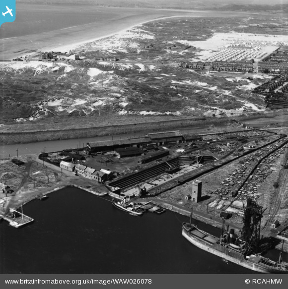
WAW026078 WALES (1949). View of docks, Port Talbot, showing derelict Jersey Beach Hotel, funfair and Sandfields estate prefabs at Aberavon in the background. Oblique aerial photograph, 5½" cut roll film.
© Copyright OpenStreetMap contributors and licensed by the OpenStreetMap Foundation. 2026. Cartography is licensed as CC BY-SA.
Nearby Images (37)
WAW005817

WAW005819

WAW005820

WAW005821

WAW005822

WAW005823

WAW005824

WAW005825

WAW005826

WAW005827

WAW006739

WAW006740

WAW006742

WAW006743

WAW006744

WAW006745

WAW006747

WAW007975

WAW007976

WAW007977

WAW026073

WAW026074

WAW026075

WAW026076

WAW026077

WAW026078

WAW026079

WAW026080

WAW026081

WAW026082

WPW043050

WPW043051

WPW043052

WPW043053

WPW043054

WPW043055

WPW043056

Details
| Title | [WAW026078] View of docks, Port Talbot, showing derelict Jersey Beach Hotel, funfair and Sandfields estate prefabs at Aberavon in the background. Oblique aerial photograph, 5½" cut roll film. |
| Reference | WAW026078 |
| Date | 12-August-1949 |
| Link | Coflein Archive Item 6423524 |
| Place name | |
| Parish | |
| District | |
| Country | WALES |
| Easting / Northing | 276000, 189000 |
| Longitude / Latitude | -3.7900131148748, 51.585721062159 |
| National Grid Reference | SS760890 |
Pins

sloyne |
Wednesday 3rd of July 2024 03:43:15 AM | |
|
sloyne |
Wednesday 3rd of July 2024 03:42:01 AM | |
|
sloyne |
Wednesday 3rd of July 2024 03:40:48 AM | |
|
sloyne |
Wednesday 3rd of July 2024 03:39:40 AM | |
|
sloyne |
Sunday 17th of October 2021 02:58:01 AM | |
|
sloyne |
Sunday 17th of October 2021 02:54:50 AM | |
|
Post-war prefabs |
Thursday 23rd of January 2020 03:14:55 PM |