
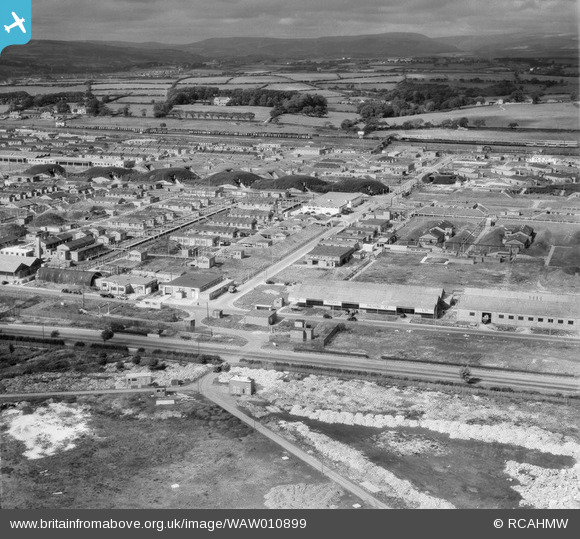
WAW010899 WALES (1947). View of Bridgend Ordnance Factory
© Copyright OpenStreetMap contributors and licensed by the OpenStreetMap Foundation. 2026. Cartography is licensed as CC BY-SA.
Nearby Images (17)
WAW010895

WAW010896

WAW010897

WAW010898

WAW010899

WAW010900

WAW010901

WAW010902

WAW010903

WAW010904

WAW010905

WAW010906

WAW010907

WAW010908

WAW010909

WAW010910

WAW010911

Details
| Title | [WAW010899] View of Bridgend Ordnance Factory |
| Reference | WAW010899 |
| Date | 20-September-1947 |
| Link | Coflein Archive Item 6413792 |
| Place name | |
| Parish | |
| District | |
| Country | WALES |
| Easting / Northing | 292500, 179000 |
| Longitude / Latitude | -3.5488715344132, 51.499219736582 |
| National Grid Reference | SS925790 |
Pins

Matt Aldred edob.mattaldred.com |
Wednesday 3rd of March 2021 05:30:18 PM | |
|
Matt Aldred edob.mattaldred.com |
Wednesday 3rd of March 2021 05:29:10 PM | |

Harvey |
Tuesday 17th of March 2015 09:01:27 PM | |
|
Harvey |
Tuesday 17th of March 2015 09:00:27 PM | |
|
Harvey |
Tuesday 17th of March 2015 08:59:13 PM | |
|
cptpies |
Friday 9th of May 2014 04:01:54 PM |
User Comment Contributions
Pillbox ROF Bridgend |
cptpies |
Friday 9th of May 2014 04:03:11 PM |