
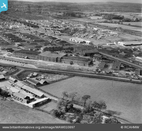
WAW010897 WALES (1947). View of Bridgend Ordnance Factory
© Copyright OpenStreetMap contributors and licensed by the OpenStreetMap Foundation. 2026. Cartography is licensed as CC BY-SA.
Nearby Images (17)
WAW010895

WAW010896

WAW010897

WAW010898

WAW010899

WAW010900

WAW010901

WAW010902

WAW010903

WAW010904

WAW010905

WAW010906

WAW010907

WAW010908

WAW010909

WAW010910

WAW010911

Details
| Title | [WAW010897] View of Bridgend Ordnance Factory |
| Reference | WAW010897 |
| Date | 20-September-1947 |
| Link | Coflein Archive Item 6413790 |
| Place name | |
| Parish | |
| District | |
| Country | WALES |
| Easting / Northing | 292500, 179000 |
| Longitude / Latitude | -3.5488715344132, 51.499219736582 |
| National Grid Reference | SS925790 |
Pins

Matt Aldred edob.mattaldred.com |
Sunday 5th of July 2026 05:18:20 PM | |

Mooonsan |
Thursday 9th of September 2021 09:17:23 PM | |
|
AI44 |
Thursday 14th of January 2016 02:32:09 PM | |
|
Harvey |
Saturday 27th of June 2015 08:47:55 PM | |
|
Harvey |
Saturday 27th of June 2015 08:33:18 PM | |
|
Harvey |
Tuesday 17th of March 2015 08:55:10 PM | |
|
Harvey |
Tuesday 17th of March 2015 08:38:59 PM | |
|
Harvey |
Tuesday 17th of March 2015 08:38:08 PM | |
|
Harvey |
Tuesday 17th of March 2015 08:32:20 PM | |
|
Harvey |
Tuesday 17th of March 2015 08:31:08 PM | |
|
cptpies |
Friday 9th of May 2014 03:59:05 PM |
User Comment Contributions
The Waterton part of Bridgend Royal Ordnance Factory (Filling Factory No 2), viewed from the south-east. The field in the foreground is now the location of Lee & Turners car dealers, to the right off-screen is the B & Q store. The fields in the distance beyond the railway line is now the site of the Brackla housing estate, |
Harvey |
Tuesday 17th of March 2015 08:54:31 PM |

Pillbox ROF Bridgend |
cptpies |
Friday 9th of May 2014 03:59:55 PM |