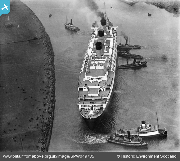
SPW049785 SCOTLAND (1936). Queen Mary, River Clyde, Clydebank. An oblique aerial photograph taken facing north-west.
© Copyright OpenStreetMap contributors and licensed by the OpenStreetMap Foundation. 2026. Cartography is licensed as CC BY-SA.
Nearby Images (22)
Details
| Title | [SPW049785] Queen Mary, River Clyde, Clydebank. An oblique aerial photograph taken facing north-west. |
| Reference | SPW049785 |
| Date | 1936 |
| Link | NRHE Collection item 1257785 |
| Place name | |
| Parish | OLD KILPATRICK (CLYDEBANK) |
| District | CLYDEBANK |
| Country | SCOTLAND |
| Easting / Northing | 249688, 669676 |
| Longitude / Latitude | -4.4041786178711, 55.896736965978 |
| National Grid Reference | NS497697 |
Pins
Be the first to add a comment to this image!
User Comment Contributions
Here, the brand new Cunard White Star liner Queen Mary, the largest ship built in Britain up to that time, is in serious difficulties. She was travelling down the River Clyde towards the open sea for her sea trials, when her bows ran aground and stuck in the mud on one bank of the meandering river. The wind caught her, and pushed her stern into the opposite bank. For half an hour, extra tugs frantically tried to push and pull her free. Had they not been able to successfully free her, on the falling tide she would have stuck fast, and almost certainly would have broken her back (keel). This would quite likely have meant she would have been ultimately been scrapped, despite being brand new. Also the Clyde would have been blocked to all shipping until she was moved. Fortunately, by the time this photo was taken, the crisis appeared over, and she then left the Clyde to sail on into the history books as probably Great Britain's most successful, famous and greatly loved ocean liner. |

Isleworth1961 |
Saturday 8th of June 2013 08:51:19 PM |


![[SPW019475] John Brown and Co. shipyards, Clydebank. An oblique aerial photograph taken facing east.](http://britainfromabove.org.uk/sites/all/libraries/aerofilms-images/public/100x100/SPW/019/SPW019475.jpg)
![[SPW049784] Queen Mary, River Clyde, Clydebank. An oblique aerial photograph taken facing south.](http://britainfromabove.org.uk/sites/all/libraries/aerofilms-images/public/100x100/SPW/049/SPW049784.jpg)
![[SPW049785] Queen Mary, River Clyde, Clydebank. An oblique aerial photograph taken facing north-west.](http://britainfromabove.org.uk/sites/all/libraries/aerofilms-images/public/100x100/SPW/049/SPW049785.jpg)
![[SPW049793] Queen Mary, River Clyde, Clydebank. An oblique aerial photograph taken facing south.](http://britainfromabove.org.uk/sites/all/libraries/aerofilms-images/public/100x100/SPW/049/SPW049793.jpg)
![[SPW049799] Queen Mary, River Clyde, Clydebank. An oblique aerial photograph taken facing south. This image has been produced from a damaged negative.](http://britainfromabove.org.uk/sites/all/libraries/aerofilms-images/public/100x100/SPW/049/SPW049799.jpg)
![[SPW053550] John Brown's Shipyard, Clydebank, Queen Elizabeth under construction. An oblique aerial photograph taken facing north. This image has been produced from a print.](http://britainfromabove.org.uk/sites/all/libraries/aerofilms-images/public/100x100/SPW/053/SPW053550.jpg)
![[SAR008774] John Brown's Yard, Clydebank Old Kilpatrick, Dunbartonshire, Scotland. An oblique aerial photograph taken facing North.](http://britainfromabove.org.uk/sites/all/libraries/aerofilms-images/public/100x100/SAR/008/SAR008774.jpg)
![[SAW024758] John Brown and Co. Shipyard, Clydebank. An oblique aerial photograph taken facing north-west.](http://britainfromabove.org.uk/sites/all/libraries/aerofilms-images/public/100x100/SAW/024/SAW024758.jpg)
![[SPW045821] John Brown's Shipyard, Clydebank, Queen Mary under construction. An oblique aerial photograph taken facing west.](http://britainfromabove.org.uk/sites/all/libraries/aerofilms-images/public/100x100/SPW/045/SPW045821.jpg)
![[SPW045822] Clydebank, general view, showing Forth and Clyde Canal and John Brown's Shipyard, Queen Mary under construction. An oblique aerial photograph taken facing north.](http://britainfromabove.org.uk/sites/all/libraries/aerofilms-images/public/100x100/SPW/045/SPW045822.jpg)
![[SPW045823] John Brown's Shipyard, Clydebank, Queen Mary under construction. An oblique aerial photograph taken facing north.](http://britainfromabove.org.uk/sites/all/libraries/aerofilms-images/public/100x100/SPW/045/SPW045823.jpg)
![[SPW048769] John Brown's Shipyard, Clydebank, Queen Mary under construction. An oblique aerial photograph taken facing east.](http://britainfromabove.org.uk/sites/all/libraries/aerofilms-images/public/100x100/SPW/048/SPW048769.jpg)
![[SPW048770] John Brown's Shipyard, Clydebank, Queen Mary under construction. An oblique aerial photograph taken facing east. This image has been produced from a print.](http://britainfromabove.org.uk/sites/all/libraries/aerofilms-images/public/100x100/SPW/048/SPW048770.jpg)
![[SPW048771] John Brown's Shipyard, Clydebank, Queen Mary under construction. An oblique aerial photograph taken facing south-west.](http://britainfromabove.org.uk/sites/all/libraries/aerofilms-images/public/100x100/SPW/048/SPW048771.jpg)
![[SPW053551] John Brown's Shipyard, Clydebank, Queen Elizabeth under construction. An oblique aerial photograph taken facing north-west. This image has been produced from a damaged print.](http://britainfromabove.org.uk/sites/all/libraries/aerofilms-images/public/100x100/SPW/053/SPW053551.jpg)
![[SAW024756] John Brown and Co. Shipyard, Clydebank. An oblique aerial photograph taken facing north.](http://britainfromabove.org.uk/sites/all/libraries/aerofilms-images/public/100x100/SAW/024/SAW024756.jpg)
![[SPW040275] John Brown's Shipyard, Clydebank, Queen Mary under construction. An oblique aerial photograph taken facing east.](http://britainfromabove.org.uk/sites/all/libraries/aerofilms-images/public/100x100/SPW/040/SPW040275.jpg)
![[SPW052992] John Brown's Shipyard, Clydebank, ship under construction. An oblique aerial photograph taken facing north-east. This image has been produced from a print.](http://britainfromabove.org.uk/sites/all/libraries/aerofilms-images/public/100x100/SPW/052/SPW052992.jpg)
![[SPW052994] John Brown's Shipyard, Clydebank, ship under construction. An oblique aerial photograph taken facing north-east. This image has been produced from a print.](http://britainfromabove.org.uk/sites/all/libraries/aerofilms-images/public/100x100/SPW/052/SPW052994.jpg)
![[SPW052995] John Brown's Shipyard, Clydebank, Queen Elizabeth under construction. An oblique aerial photograph taken facing north. This image has been produced from a print.](http://britainfromabove.org.uk/sites/all/libraries/aerofilms-images/public/100x100/SPW/052/SPW052995.jpg)
![[SPW053000] River Clyde, general view, showing Clydebank and Scotstoun. An oblique aerial photograph taken facing south-east.](http://britainfromabove.org.uk/sites/all/libraries/aerofilms-images/public/100x100/SPW/053/SPW053000.jpg)
![[SPW053549] John Brown's Shipyard, Clydebank, Queen Elizabeth under construction. An oblique aerial photograph taken facing south. This image has been produced from a damaged print.](http://britainfromabove.org.uk/sites/all/libraries/aerofilms-images/public/100x100/SPW/053/SPW053549.jpg)