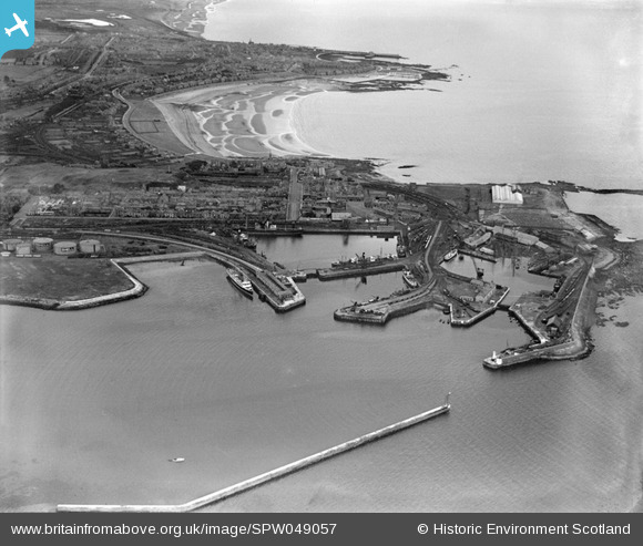
SPW049057 SCOTLAND (1935). Ardrossan, general view, showing Ardrossan Harbour and South Bay. An oblique aerial photograph taken facing south-east.
© Copyright OpenStreetMap contributors and licensed by the OpenStreetMap Foundation. 2026. Cartography is licensed as CC BY-SA.
Nearby Images (29)
Details
| Title | [SPW049057] Ardrossan, general view, showing Ardrossan Harbour and South Bay. An oblique aerial photograph taken facing south-east. |
| Reference | SPW049057 |
| Date | 1935 |
| Link | NRHE Collection item 1257965 |
| Place name | |
| Parish | ARDROSSAN |
| District | CUNNINGHAME |
| Country | SCOTLAND |
| Easting / Northing | 222640, 642200 |
| Longitude / Latitude | -4.818391430152, 55.640935904701 |
| National Grid Reference | NS226422 |
Pins
Be the first to add a comment to this image!


![[SPW049056] Ardrossan Harbour. An oblique aerial photograph taken facing south.](http://britainfromabove.org.uk/sites/all/libraries/aerofilms-images/public/100x100/SPW/049/SPW049056.jpg)
![[SPW049057] Ardrossan, general view, showing Ardrossan Harbour and South Bay. An oblique aerial photograph taken facing south-east.](http://britainfromabove.org.uk/sites/all/libraries/aerofilms-images/public/100x100/SPW/049/SPW049057.jpg)
![[SPW050793] Ardrossan Harbour and South Bay, Ardrossan. An oblique aerial photograph taken facing east.](http://britainfromabove.org.uk/sites/all/libraries/aerofilms-images/public/100x100/SPW/050/SPW050793.jpg)
![[SPW056869] Ardrossan, general view, showing Ardrossan Harbour and South Bay. An oblique aerial photograph taken facing south-east. This image has been produced from a print.](http://britainfromabove.org.uk/sites/all/libraries/aerofilms-images/public/100x100/SPW/056/SPW056869.jpg)
![[SPW050788] Ardrossan Harbour and South Bay, Ardrossan. An oblique aerial photograph taken facing east.](http://britainfromabove.org.uk/sites/all/libraries/aerofilms-images/public/100x100/SPW/050/SPW050788.jpg)
![[SPW050796] Inner Harbour and Montgomerie Pier, Ardrossan. An oblique aerial photograph taken facing north.](http://britainfromabove.org.uk/sites/all/libraries/aerofilms-images/public/100x100/SPW/050/SPW050796.jpg)
![[SPW050799] Ardrossan Harbour. An oblique aerial photograph taken facing west.](http://britainfromabove.org.uk/sites/all/libraries/aerofilms-images/public/100x100/SPW/050/SPW050799.jpg)
![[SPW050809] Inner Harbour and Ardrossan Refinery, Ardrossan. An oblique aerial photograph taken facing north.](http://britainfromabove.org.uk/sites/all/libraries/aerofilms-images/public/100x100/SPW/050/SPW050809.jpg)
![[SPW049054] Inner and Outer Harbours and Montgomerie Pier, Ardrossan. An oblique aerial photograph taken facing east.](http://britainfromabove.org.uk/sites/all/libraries/aerofilms-images/public/100x100/SPW/049/SPW049054.jpg)
![[SPW049055] Ardrossan, general view, showing Ardrossan Harbour and South Bay. An oblique aerial photograph taken facing east.](http://britainfromabove.org.uk/sites/all/libraries/aerofilms-images/public/100x100/SPW/049/SPW049055.jpg)
![[SPW050795] Inner and Outer Harbours and Winton Pier, Ardrossan. An oblique aerial photograph taken facing south-east.](http://britainfromabove.org.uk/sites/all/libraries/aerofilms-images/public/100x100/SPW/050/SPW050795.jpg)
![[SPW050798] Outer Harbour and Winton Pier, Ardrossan. An oblique aerial photograph taken facing west.](http://britainfromabove.org.uk/sites/all/libraries/aerofilms-images/public/100x100/SPW/050/SPW050798.jpg)
![[SPW056871] Ardrossan, general view, showing Ardrossan Harbour and Castle Hill. An oblique aerial photograph taken facing east. This image has been produced from a print.](http://britainfromabove.org.uk/sites/all/libraries/aerofilms-images/public/100x100/SPW/056/SPW056871.jpg)
![[SPW050794] Montgomerie Pier and Inner Harbour, Ardrossan. An oblique aerial photograph taken facing south.](http://britainfromabove.org.uk/sites/all/libraries/aerofilms-images/public/100x100/SPW/050/SPW050794.jpg)
![[SPW050810] Ardrossan, general view, showing Montgomerie Pier and Ardrossan Refinery. An oblique aerial photograph taken facing east.](http://britainfromabove.org.uk/sites/all/libraries/aerofilms-images/public/100x100/SPW/050/SPW050810.jpg)
![[SPW050811] Ardrossan Harbour. An oblique aerial photograph taken facing north.](http://britainfromabove.org.uk/sites/all/libraries/aerofilms-images/public/100x100/SPW/050/SPW050811.jpg)
![[SPW050816] Montgomerie Pier and Winton Pier, Ardrossan Harbour. An oblique aerial photograph taken facing north-east.](http://britainfromabove.org.uk/sites/all/libraries/aerofilms-images/public/100x100/SPW/050/SPW050816.jpg)
![[SPW050815] Outer Harbour and Winton Pier, Ardrossan. An oblique aerial photograph taken facing west.](http://britainfromabove.org.uk/sites/all/libraries/aerofilms-images/public/100x100/SPW/050/SPW050815.jpg)
![[SPW056866] Ardrossan Harbour. An oblique aerial photograph taken facing north.](http://britainfromabove.org.uk/sites/all/libraries/aerofilms-images/public/100x100/SPW/056/SPW056866.jpg)
![[SPW056896] Ardrossan Harbour. An oblique aerial photograph taken facing east.](http://britainfromabove.org.uk/sites/all/libraries/aerofilms-images/public/100x100/SPW/056/SPW056896.jpg)
![[SPW019561] Ardrossan Harbour. An oblique aerial photograph taken facing east. This image has been produced from a print.](http://britainfromabove.org.uk/sites/all/libraries/aerofilms-images/public/100x100/SPW/019/SPW019561.jpg)
![[SPW050789] Ardrossan Harbour. An oblique aerial photograph taken facing east.](http://britainfromabove.org.uk/sites/all/libraries/aerofilms-images/public/100x100/SPW/050/SPW050789.jpg)
![[SPW050801] Ardrossan Old Dock and Breakwater, Ardrossan. An oblique aerial photograph taken facing north.](http://britainfromabove.org.uk/sites/all/libraries/aerofilms-images/public/100x100/SPW/050/SPW050801.jpg)
![[SPW050803] Ardrossan Harbour. An oblique aerial photograph taken facing north-east.](http://britainfromabove.org.uk/sites/all/libraries/aerofilms-images/public/100x100/SPW/050/SPW050803.jpg)
![[SPW050804] Ardrossan Old Dock and South Bay, Ardrossan. An oblique aerial photograph taken facing east.](http://britainfromabove.org.uk/sites/all/libraries/aerofilms-images/public/100x100/SPW/050/SPW050804.jpg)
![[SPW050806] Ardrossan Harbour. An oblique aerial photograph taken facing south-east.](http://britainfromabove.org.uk/sites/all/libraries/aerofilms-images/public/100x100/SPW/050/SPW050806.jpg)
![[SPW056870] Ardrossan Harbour and Refinery. An oblique aerial photograph taken facing north. This image has been produced from a print.](http://britainfromabove.org.uk/sites/all/libraries/aerofilms-images/public/100x100/SPW/056/SPW056870.jpg)
![[SAR018740] General View Ardrossan, Ayrshire, Scotland. An oblique aerial photograph taken facing South.](http://britainfromabove.org.uk/sites/all/libraries/aerofilms-images/public/100x100/SAR/018/SAR018740.jpg)
![[SPW050808] Ardrossan Harbour and Firth of Clyde. An oblique aerial photograph taken facing west.](http://britainfromabove.org.uk/sites/all/libraries/aerofilms-images/public/100x100/SPW/050/SPW050808.jpg)