
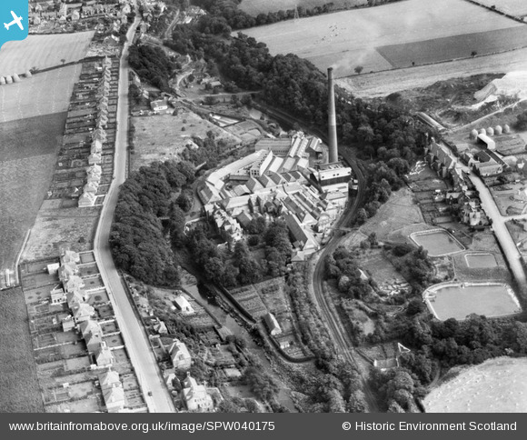
SPW040175 SCOTLAND (1932). Kinleith Paper Mills, Currie. An oblique aerial photograph taken facing east.
© Copyright OpenStreetMap contributors and licensed by the OpenStreetMap Foundation. 2026. Cartography is licensed as CC BY-SA.
Nearby Images (6)
SAR029093

SPW040175

SPW040177

SPW040178

SAR010319

SPW040180

Details
| Title | [SPW040175] Kinleith Paper Mills, Currie. An oblique aerial photograph taken facing east. |
| Reference | SPW040175 |
| Date | 1932 |
| Link | NRHE Collection item 1257258 |
| Place name | |
| Parish | CURRIE |
| District | CITY OF EDINBURGH |
| Country | SCOTLAND |
| Easting / Northing | 318950, 667970 |
| Longitude / Latitude | -3.2963052669466, 55.898054696293 |
| National Grid Reference | NT190680 |
Pins
Be the first to add a comment to this image!
User Comment Contributions
featuring Kinleith Mill's gardener's cottage & one of the oldest dwellings in Currie, "the square" aka Four Ways which has had half of it removed by the building of the Balerno Branch Line. nice to see it's a washing day ! Also showing Blinkbonny Mains , now demolished & the Kinleith Pavilion for the curling rink alongside the reservoirs for the paper mill. Wurz |

Ken Watt |
Thursday 28th of June 2012 11:13:03 AM |