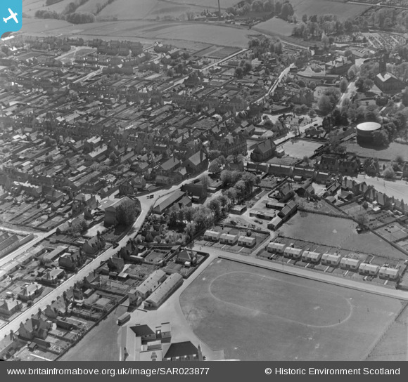
SAR023877 SCOTLAND (1955). General View Keith, Banff, Scotland. An oblique aerial photograph taken facing South.
    © Copyright OpenStreetMap contributors and licensed by the OpenStreetMap Foundation. 2025. Cartography is licensed as CC BY-SA.
  
Nearby Images (9)
Details
| Title | [SAR023877] General View Keith, Banff, Scotland. An oblique aerial photograph taken facing South. | 
| Reference | SAR023877 | 
| Date | 1955 | 
| Link | NRHE Collection item 1438407 | 
| Place name | |
| Parish | KEITH | 
| District | MORAY | 
| Country | SCOTLAND | 
| Easting / Northing | 343227, 850477 | 
| Longitude / Latitude | -2.9484845549768, 57.541085120512 | 
| National Grid Reference | NJ432505 | 
Pins
Be the first to add a comment to this image!
 
             
  ![[SAR023875] General View Keith, Banff, Scotland. An oblique aerial photograph taken facing North.](http://britainfromabove.org.uk/sites/all/libraries/aerofilms-images/public/100x100/SAR/023/SAR023875.jpg) 
  
                                          ![[SAR023876] General View Keith, Banff, Scotland. An oblique aerial photograph taken facing South. This image was marked by AeroPictorial Ltd for photo editing.](http://britainfromabove.org.uk/sites/all/libraries/aerofilms-images/public/100x100/SAR/023/SAR023876.jpg) 
 ![[SAR023877] General View Keith, Banff, Scotland. An oblique aerial photograph taken facing South.](http://britainfromabove.org.uk/sites/all/libraries/aerofilms-images/public/100x100/SAR/023/SAR023877.jpg) 
 ![[SAR025574] General View Keith, Banff, Scotland. An oblique aerial photograph taken facing South.](http://britainfromabove.org.uk/sites/all/libraries/aerofilms-images/public/100x100/SAR/025/SAR025574.jpg) 
 ![[SPW033655] Keith, general view, showing Land Street and Union Street.  An oblique aerial photograph taken facing east.  This image has been produced from a print.](http://britainfromabove.org.uk/sites/all/libraries/aerofilms-images/public/100x100/SPW/033/SPW033655.jpg) 
 ![[SPW033651] Keith, general view, showing Land Street and Union Street.  An oblique aerial photograph taken facing east.  This image has been produced from a print.](http://britainfromabove.org.uk/sites/all/libraries/aerofilms-images/public/100x100/SPW/033/SPW033651.jpg) 
 ![[SPW033652] Keith, general view, showing Land Street and Moss Street.  An oblique aerial photograph taken facing south.  This image has been produced from a print.](http://britainfromabove.org.uk/sites/all/libraries/aerofilms-images/public/100x100/SPW/033/SPW033652.jpg) 
 ![[SPW033653] Keith, general view, showing Church Road and Mid Street.  An oblique aerial photograph taken facing south.  This image has been produced from a print.](http://britainfromabove.org.uk/sites/all/libraries/aerofilms-images/public/100x100/SPW/033/SPW033653.jpg) 
 ![[SPW033649] Keith, general view, showing St Thomas' Roman Catholic Church and Land Street.  An oblique aerial photograph taken facing north-east.](http://britainfromabove.org.uk/sites/all/libraries/aerofilms-images/public/100x100/SPW/033/SPW033649.jpg)