
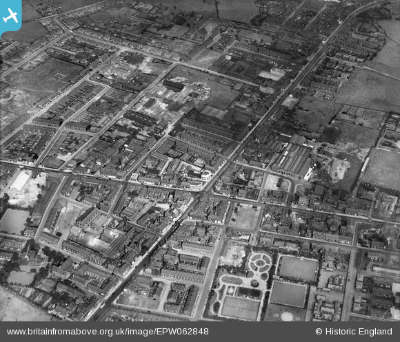
EPW062848 ENGLAND (1939). The town centre, Denton, 1939
© Copyright OpenStreetMap contributors and licensed by the OpenStreetMap Foundation. 2026. Cartography is licensed as CC BY-SA.
Nearby Images (9)
EPW062848

EPW029890

EPW029888

EPW062843

EPW062846

EPW029889

EPW062842

EPW062844

EPW062849

Details
| Title | [EPW062848] The town centre, Denton, 1939 |
| Reference | EPW062848 |
| Date | 30-August-1939 |
| Link | |
| Place name | DENTON |
| Parish | |
| District | |
| Country | ENGLAND |
| Easting / Northing | 392614, 395544 |
| Longitude / Latitude | -2.1112446228454, 53.4563429889 |
| National Grid Reference | SJ926955 |
Pins

totoro |
Friday 21st of March 2014 04:22:23 PM | |
|
totoro |
Friday 21st of March 2014 04:21:38 PM | |
|
totoro |
Friday 21st of March 2014 04:20:41 PM | |
|
totoro |
Friday 21st of March 2014 04:19:51 PM | |
|
totoro |
Friday 21st of March 2014 04:19:27 PM | |
|
totoro |
Friday 21st of March 2014 04:19:05 PM | |
|
totoro |
Friday 21st of March 2014 04:14:36 PM | |
|
totoro |
Friday 21st of March 2014 04:14:12 PM | |
|
totoro |
Friday 21st of March 2014 04:13:26 PM | |
|
totoro |
Friday 21st of March 2014 04:12:59 PM | |
|
totoro |
Friday 21st of March 2014 04:12:40 PM | |
|
totoro |
Friday 21st of March 2014 04:11:54 PM | |
|
totoro |
Friday 21st of March 2014 04:11:36 PM |