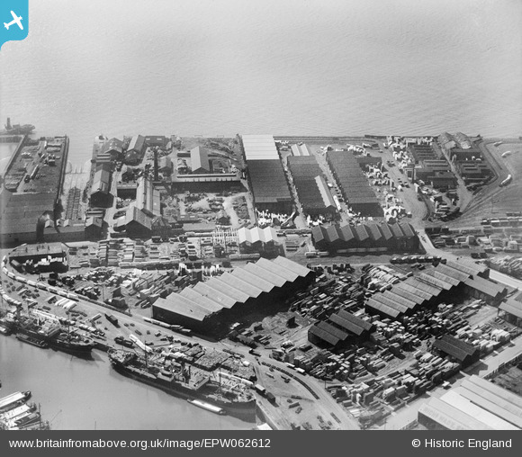
EPW062612 ENGLAND (1939). Timber Yards on Garrison Side, Kingston upon Hull, 1939
© Copyright OpenStreetMap contributors and licensed by the OpenStreetMap Foundation. 2026. Cartography is licensed as CC BY-SA.
Nearby Images (10)
Details
| Title | [EPW062612] Timber Yards on Garrison Side, Kingston upon Hull, 1939 |
| Reference | EPW062612 |
| Date | 9-August-1939 |
| Link | |
| Place name | KINGSTON UPON HULL |
| Parish | |
| District | |
| Country | ENGLAND |
| Easting / Northing | 510682, 428516 |
| Longitude / Latitude | -0.32163966246848, 53.741038346141 |
| National Grid Reference | TA107285 |
Pins

John Wass |
Friday 26th of December 2014 09:00:47 PM |


![[EPW062612] Timber Yards on Garrison Side, Kingston upon Hull, 1939](http://britainfromabove.org.uk/sites/all/libraries/aerofilms-images/public/100x100/EPW/062/EPW062612.jpg)
![[EPW062615] Timber Yards on Garrison Side, Kingston upon Hull, 1939. This image has been affected by flare.](http://britainfromabove.org.uk/sites/all/libraries/aerofilms-images/public/100x100/EPW/062/EPW062615.jpg)
![[EPW062611] Timber Yards on Garrison Side, Kingston upon Hull, 1939](http://britainfromabove.org.uk/sites/all/libraries/aerofilms-images/public/100x100/EPW/062/EPW062611.jpg)
![[EPW062614] Timber Yards on Garrison Side, Kingston upon Hull, 1939](http://britainfromabove.org.uk/sites/all/libraries/aerofilms-images/public/100x100/EPW/062/EPW062614.jpg)
![[EPW062613] Timber Yards on Garrison Side, Kingston upon Hull, 1939. This image has been affected by flare.](http://britainfromabove.org.uk/sites/all/libraries/aerofilms-images/public/100x100/EPW/062/EPW062613.jpg)
![[EPW036426] The London and North Eastern Railway Dock Yard, Victoria Dock and environs, Kingston upon Hull, from the south-west, 1931](http://britainfromabove.org.uk/sites/all/libraries/aerofilms-images/public/100x100/EPW/036/EPW036426.jpg)
![[EPW012702] Timber yards at Garrison Side, Kingston upon Hull, 1925](http://britainfromabove.org.uk/sites/all/libraries/aerofilms-images/public/100x100/EPW/012/EPW012702.jpg)
![[EPW036437] The London and North Eastern Railway Dock Yard, Victoria Dock and environs, Kingston upon Hull, from the south-west, 1931](http://britainfromabove.org.uk/sites/all/libraries/aerofilms-images/public/100x100/EPW/036/EPW036437.jpg)
![[EPW036528] Garrison Side and the city, Kingston upon Hull, from the south-east, 1931](http://britainfromabove.org.uk/sites/all/libraries/aerofilms-images/public/100x100/EPW/036/EPW036528.jpg)
![[EAW046143] Victoria Dock and the city, Kingston upon Hull, from the south-east, 1952](http://britainfromabove.org.uk/sites/all/libraries/aerofilms-images/public/100x100/EAW/046/EAW046143.jpg)