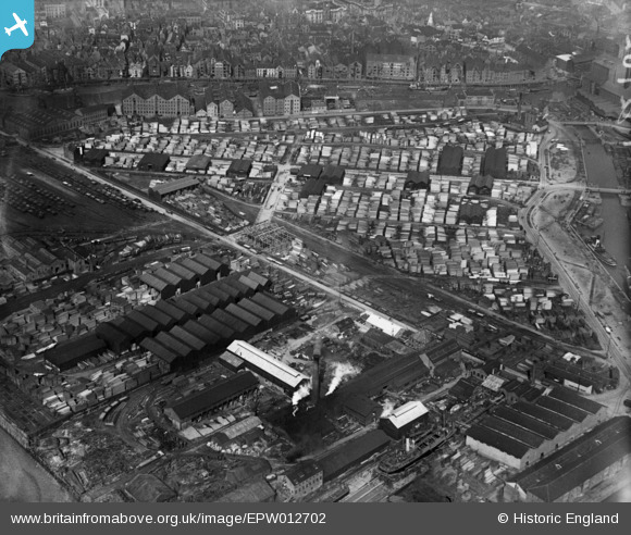
EPW012702 ENGLAND (1925). Timber yards at Garrison Side, Kingston upon Hull, 1925
© Copyright OpenStreetMap contributors and licensed by the OpenStreetMap Foundation. 2026. Cartography is licensed as CC BY-SA.
Nearby Images (11)
Details
| Title | [EPW012702] Timber yards at Garrison Side, Kingston upon Hull, 1925 |
| Reference | EPW012702 |
| Date | 6-May-1925 |
| Link | |
| Place name | KINGSTON UPON HULL |
| Parish | |
| District | |
| Country | ENGLAND |
| Easting / Northing | 510602, 428567 |
| Longitude / Latitude | -0.32283394408923, 53.741513571136 |
| National Grid Reference | TA106286 |
Pins

ladyceecee |
Saturday 26th of March 2022 08:05:20 PM | |

ladyceecee |
Saturday 26th of March 2022 08:01:29 PM | |

ladyceecee |
Saturday 26th of March 2022 07:54:51 PM | |

ladyceecee |
Saturday 26th of March 2022 07:53:47 PM | |

ladyceecee |
Saturday 26th of March 2022 07:52:31 PM | |

ladyceecee |
Saturday 26th of March 2022 07:48:38 PM | |

John Wass |
Wednesday 22nd of April 2015 03:32:41 PM |


![[EPW012702] Timber yards at Garrison Side, Kingston upon Hull, 1925](http://britainfromabove.org.uk/sites/all/libraries/aerofilms-images/public/100x100/EPW/012/EPW012702.jpg)
![[EPW036528] Garrison Side and the city, Kingston upon Hull, from the south-east, 1931](http://britainfromabove.org.uk/sites/all/libraries/aerofilms-images/public/100x100/EPW/036/EPW036528.jpg)
![[EPW062615] Timber Yards on Garrison Side, Kingston upon Hull, 1939. This image has been affected by flare.](http://britainfromabove.org.uk/sites/all/libraries/aerofilms-images/public/100x100/EPW/062/EPW062615.jpg)
![[EPW062613] Timber Yards on Garrison Side, Kingston upon Hull, 1939. This image has been affected by flare.](http://britainfromabove.org.uk/sites/all/libraries/aerofilms-images/public/100x100/EPW/062/EPW062613.jpg)
![[EPW062614] Timber Yards on Garrison Side, Kingston upon Hull, 1939](http://britainfromabove.org.uk/sites/all/libraries/aerofilms-images/public/100x100/EPW/062/EPW062614.jpg)
![[EPW062611] Timber Yards on Garrison Side, Kingston upon Hull, 1939](http://britainfromabove.org.uk/sites/all/libraries/aerofilms-images/public/100x100/EPW/062/EPW062611.jpg)
![[EPW062612] Timber Yards on Garrison Side, Kingston upon Hull, 1939](http://britainfromabove.org.uk/sites/all/libraries/aerofilms-images/public/100x100/EPW/062/EPW062612.jpg)
![[EPW036426] The London and North Eastern Railway Dock Yard, Victoria Dock and environs, Kingston upon Hull, from the south-west, 1931](http://britainfromabove.org.uk/sites/all/libraries/aerofilms-images/public/100x100/EPW/036/EPW036426.jpg)
![[EPW036437] The London and North Eastern Railway Dock Yard, Victoria Dock and environs, Kingston upon Hull, from the south-west, 1931](http://britainfromabove.org.uk/sites/all/libraries/aerofilms-images/public/100x100/EPW/036/EPW036437.jpg)
![[EPW036561] Garrison Side, Kingston upon Hull, 1931](http://britainfromabove.org.uk/sites/all/libraries/aerofilms-images/public/100x100/EPW/036/EPW036561.jpg)
![[EAW015659] Victoria Dock and the city, Kingston upon Hull, from the south, 1948. This image has been produced from a print.](http://britainfromabove.org.uk/sites/all/libraries/aerofilms-images/public/100x100/EAW/015/EAW015659.jpg)