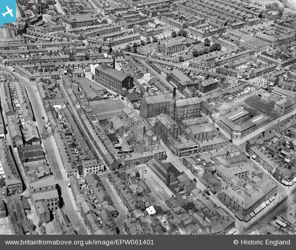
EPW061401 ENGLAND (1939). Pole Street Mill and surrounding streets, Preston, 1939
© Copyright OpenStreetMap contributors and licensed by the OpenStreetMap Foundation. 2026. Cartography is licensed as CC BY-SA.
Nearby Images (11)
Details
| Title | [EPW061401] Pole Street Mill and surrounding streets, Preston, 1939 |
| Reference | EPW061401 |
| Date | 2-June-1939 |
| Link | |
| Place name | PRESTON |
| Parish | |
| District | |
| Country | ENGLAND |
| Easting / Northing | 354306, 429608 |
| Longitude / Latitude | -2.6931922965086, 53.760602085597 |
| National Grid Reference | SD543296 |
Pins

Robert - Cumbria |
Thursday 6th of February 2014 10:02:31 PM | |

Robert - Cumbria |
Thursday 6th of February 2014 09:59:27 PM | |

Robert - Cumbria |
Thursday 6th of February 2014 09:58:51 PM | |

Robert - Cumbria |
Thursday 6th of February 2014 09:45:35 PM | |

Robert - Cumbria |
Thursday 6th of February 2014 09:43:02 PM | |

Robert - Cumbria |
Thursday 6th of February 2014 09:42:24 PM | |

Robert - Cumbria |
Thursday 6th of February 2014 09:40:58 PM | |

Robert - Cumbria |
Thursday 6th of February 2014 09:35:32 PM | |

Robert - Cumbria |
Thursday 6th of February 2014 09:29:13 PM | |

Robert - Cumbria |
Thursday 6th of February 2014 09:28:29 PM | |

Robert - Cumbria |
Thursday 6th of February 2014 09:27:44 PM |


![[EPW061401] Pole Street Mill and surrounding streets, Preston, 1939](http://britainfromabove.org.uk/sites/all/libraries/aerofilms-images/public/100x100/EPW/061/EPW061401.jpg)
![[EPW061403] Pole Street Mill and surrounding streets, Preston, 1939](http://britainfromabove.org.uk/sites/all/libraries/aerofilms-images/public/100x100/EPW/061/EPW061403.jpg)
![[EPW061406] Pole Street Mill, Woods Tobacco Factory and surrounding streets, Preston, 1939](http://britainfromabove.org.uk/sites/all/libraries/aerofilms-images/public/100x100/EPW/061/EPW061406.jpg)
![[EPW061400] Lord's Walk, Pole Street and environs, Preston, 1939](http://britainfromabove.org.uk/sites/all/libraries/aerofilms-images/public/100x100/EPW/061/EPW061400.jpg)
![[EAW023380] The city centre, Preston, 1949](http://britainfromabove.org.uk/sites/all/libraries/aerofilms-images/public/100x100/EAW/023/EAW023380.jpg)
![[EAW023381] Horrockses, Crewdson and Co Ltd Yard Works (Cotton) and environs, Preston, 1949](http://britainfromabove.org.uk/sites/all/libraries/aerofilms-images/public/100x100/EAW/023/EAW023381.jpg)
![[EAW015902] The Yard Works and environs, Preston, 1948. This image has been produced from a print marked by Aerofilms Ltd for photo editing.](http://britainfromabove.org.uk/sites/all/libraries/aerofilms-images/public/100x100/EAW/015/EAW015902.jpg)
![[EPW061404] Hopwood Street Mills, St Paul's Church and surrounding streets, Preston, 1939](http://britainfromabove.org.uk/sites/all/libraries/aerofilms-images/public/100x100/EPW/061/EPW061404.jpg)
![[EAW015909] The Yard Works and environs, Preston, 1948. This image has been produced from a print marked by Aerofilms Ltd for photo editing.](http://britainfromabove.org.uk/sites/all/libraries/aerofilms-images/public/100x100/EAW/015/EAW015909.jpg)
![[EPW061405] Hopwood Street Mills, St Paul's Church and surrounding streets, Preston, 1939](http://britainfromabove.org.uk/sites/all/libraries/aerofilms-images/public/100x100/EPW/061/EPW061405.jpg)
![[EPW061402] Hopwood Street Mills and surrounding streets, Preston, 1939](http://britainfromabove.org.uk/sites/all/libraries/aerofilms-images/public/100x100/EPW/061/EPW061402.jpg)