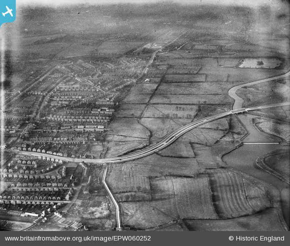
EPW060252 ENGLAND (1938). The A5111 (Raynesway) crossing fields to the south of the River Derwent, Alvaston, 1938
© Copyright OpenStreetMap contributors and licensed by the OpenStreetMap Foundation. 2026. Cartography is licensed as CC BY-SA.
Details
| Title | [EPW060252] The A5111 (Raynesway) crossing fields to the south of the River Derwent, Alvaston, 1938 |
| Reference | EPW060252 |
| Date | 1-December-1938 |
| Link | |
| Place name | ALVASTON |
| Parish | |
| District | |
| Country | ENGLAND |
| Easting / Northing | 438349, 333953 |
| Longitude / Latitude | -1.429809712292, 52.901326697944 |
| National Grid Reference | SK383340 |
Pins

Peter Kazmierczak |
Saturday 5th of October 2013 02:39:38 PM | |

Peter Kazmierczak |
Saturday 5th of October 2013 02:38:15 PM | |

Peter Kazmierczak |
Saturday 5th of October 2013 02:36:32 PM | |

Peter Kazmierczak |
Saturday 5th of October 2013 02:35:38 PM | |

Peter Kazmierczak |
Saturday 5th of October 2013 02:34:35 PM | |

Peter Kazmierczak |
Saturday 5th of October 2013 02:33:25 PM | |

Peter Kazmierczak |
Saturday 5th of October 2013 02:32:18 PM | |

Peter Kazmierczak |
Saturday 5th of October 2013 02:31:06 PM | |

Peter Kazmierczak |
Saturday 5th of October 2013 02:30:21 PM |


![[EPW060252] The A5111 (Raynesway) crossing fields to the south of the River Derwent, Alvaston, 1938](http://britainfromabove.org.uk/sites/all/libraries/aerofilms-images/public/100x100/EPW/060/EPW060252.jpg)
![[EPW060260] The A5111 (Raynesway) crossing fields to the south of the River Derwent, Alvaston, 1938](http://britainfromabove.org.uk/sites/all/libraries/aerofilms-images/public/100x100/EPW/060/EPW060260.jpg)
![[EPW055797] Construction of Raynesway (Town Planning Road No 4) by the River Derwent crossing, Alvaston, 1937](http://britainfromabove.org.uk/sites/all/libraries/aerofilms-images/public/100x100/EPW/055/EPW055797.jpg)
![[EPW055795] The outskirts of Alvaston and construction of Raynesway (Town Planning Road No 4), Alvaston, 1937](http://britainfromabove.org.uk/sites/all/libraries/aerofilms-images/public/100x100/EPW/055/EPW055795.jpg)